Now that reachview supports coordinate systems other than WSG84, I can keep the survey in the native coordinate system (around here usually 3TM or UTM). However, when starting a new project, there is a nice informative line at the bottom that says “Make sure your base or NTRIP is in NAD83”. I don’t see any option to change that in the base settings.
I am unable to find a way to actually input any other coordinate system in the base when setting up on a known point.
At this point, I have got the system working by converting the base into WGS84 Lat/Long, however that is a HUGE source of potential error if the conversion is not perfect.
@millsy.g – you need to convert the WGS84 coordinates to NAD83. The NOAA VDatum tool is a handy online app for coordinate conversion, both horizontal and vertical: Online VDatum: Vertical Datums Transformation (noaa.gov). After conversion, you can just plug in the coordinates in the “manual” setting of the “base mode.” Hope that helps!
k.
That site does not have Canadian datums that I can see.
I use Global Mapper to do my conversions.
The main issue is if I’m in the field, I am unable to just plug in control points that I get from a consultant unless I have time in the office. I had to use an online conversion site a few days ago, and the precision was not great, so I was out about 3cm horizontally. (not a huge deal for what I was doing).
Like I said, a potential source of error. If the software can handle inputing coordinates in the rover natively, there really shouldn’t be any reason not to do it for the base as well.
Each coordinate system in ReachView 3 has the corresponding coordinate system of the base station. It is needed to apply all the transformations in the correct way.
Thanks for your request. We’ll think about if there is a way to add other options to the ReachView 3 in the future.
I’m not really sure I understand then. There is no way to change the coordinate system of the base that I can see. The only thing I can do is transfer the coordinate of the known point to NAD83 and tell the base that is where it is (in Lat/long).
You are right. You will need to place the base over the known point and enter the NAD83 LLH coordinates of this point in the Base mode tab. The base coordinates should be in LLH, as RTCM3 messages support geographic coordinates only.
What base coordinate datum is the RS2 expecting in relation to the RTCM3 correction it receives?
edit** rv3 says the base must be wgs84 if working in wgs84
the base must be in NAD83 if working in NAD83
All of a sudden driving a tractor super straight is really easy in comparison to finding an absolute point on the earth. The math behind these datum is pretty neat.
May I ask, what is the difference between NAD83 LLH and WGS 84 LLH? I currently convert all the Lat/Lon to NAD83 USft (EPSG 2965/2966 in Indiana). And then when I convert back for stakeout, I use WGS84 Lat/Lon.
If you want to use nad 83 in rv3, it says the base must be in nad 83. The base llh coordinates must match the desired datum at the rover. If you want it to line up with existing survey in an area.
In wgs84 or nad83 a meter is still a meter, but its absolute reference to a position on earth, and absolute elevation are different.
As @PotatoFarmer noticed, the ReachView 3 app shows a note with the required coordinate system of the base. If the coordinate system you use is based on NAD83, you will need to enter NAD83 LLH on the base unit.
For stakeout, points should be in the same coordinate system and units as the project.
Hi there, is placing the base over a known point a requirement for using a different coordinate system? If I am obtaining a base position through Average Single to be processed later through PPK, is it only going to be collecting in WGS84? I’m hoping to conduct a survey using a local coordinate system but I will not have a benchmark to set up the base station over. I’d like to avoid having to transform the data from one CS to another as I imagine it will produce error in my final measurements. Thanks!
If you are having the base station averaging the point, you can still use any coordinate system on the rover. The base will be ‘WGS84’, but it doesn’t matter since it’s not using a known point. You will just be getting a relative position until you correct it.
The only reason you need to make sure the conversion is correct over a known point, is because if you tell it you are over a known point, but don’t use the correct coordinate system, the conversion will shift your rover by whatever the difference is between the actual base coordinates, and the wrong coordinates.
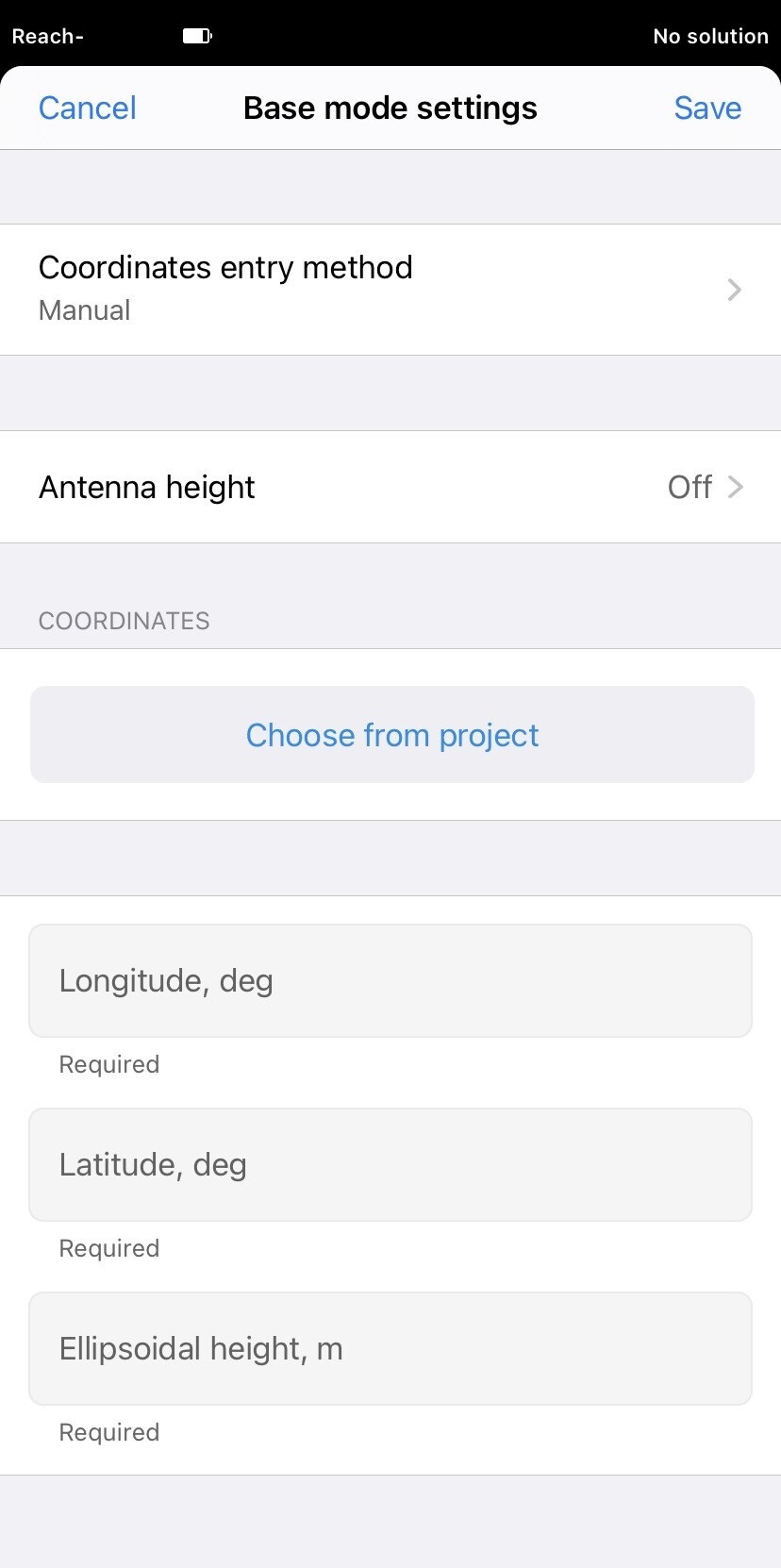
With the latest ReachView 3 version 7.3, you can pick the base coordinates from ReachView 3 project. It means there is no more need to convert the base coordinates to the geographic system.
For example, if you work in some NAD83 UTM zone and have the base coordinates in the same system, just add it to the project. In the Base mode, you’ll be able to choose it: