Somebody please help I pull my hair out how do you pick the right coordinate system for your area pardon the stupid question from the Newbie
Hi @tjulie926,
It’s actually a good question, especially if you’ve just begun your journey in learning coordinate systems ![]()
Official institutions or companies often ask for projects in some particular coordinate system (CS) and vertical datum. In this case, you can check the required CS with them.
If you just want to explore the ReachView 3 app, I’d suggest either to:
-
Choose the Global CS option. It works worldwide and provides latitude, longitude, and ellipsoidal height.
-
Follow the recommendations from our Working with coordinate systems guide if your country is already on the list.
1 Like
I am trying to work with fieldgenius for Android and I have no idea which coordinate system to pick for my geographical area that’ll work with reach View
I am trying to set up in Kalama Washington USA
Usually, a good start for “planimetric” work is to use the local flavor of UTM. But then again, it really comes down to what your clients will ask you to deliver. For your location, check a map like this one, you’ll be able to see in which UTM zone you sit. Then you need to decide which datum to use, but that’s a whole other can of worms.
The only “right” CRS is the one that was used last time but usually the most common systems used for new surveys are NAD83 (2011) either in meters or usft. Washington has two SP zones, north and south. With all the assumptions I would guess 6599.
I am sorry to say I just don’t understand I’m trying to find these in fieldgenius for Android and I just can’t find these.sorry for being stupid on this. this is over my head
this is a private project just for me so what I really need is a coordinate system that’ll work with dronedeploy fieldgenius for Android and reach View
My biggest problem is trying to find the stuff in fieldgenius for Android
And thanks for the help putting up with a bunch of stupid questions
Hi, here is a link to the Fieldgenius Quickstart Guide that should help you get started with implementing a Coordinate System into your project using Fieldgenius for Android starting on page 3.
Also a link to some training movies from FieldGenius
https://helpdesk.microsurvey.com/index.php?/Knowledgebase/Article/View/1622/252/fga-movies
Like Michael said above, it looks like your in the State Plane
EPSG:6599 ## NAD83(2011) / Washington South (ftUS) coordinate system.
Or you could choose the UTM Zone: 10 for the coordinate system.
Like said above, it’s usually dictated by your clients or past usage on the site.
What is the difference between State Plane and UTM coordinate systems?
State plane coordinate system
Because SPCS needs such a high level of accuracy, it divides the United States into 124 zones, each with a projection of its own. Overall, the State Plane Coordinate System minimizes distortion (compared to the UTM system) because of the smaller zone sizes.
Then you will need to select the vertical datum to use on the project also.
Here in the States, it is usually g2012bu6.bin
Good luck,
Mark
2 Likes
I’m a newbie as well but you just mentioned DroneDeploy in this post. Are you setting ground Control points for DroneDeploy?
yes i am
and i am also trying to import from dronedeploy and reach in to
fieldgenius for android but when i setup fieldgenius for android
i have no idea what system to uses for my location that will work with dronedepoly and reach
In the top right hand corner of your project in DD you will see a settings button(wheel). When you click that a window will pop up and in the “map projections” drop down you will see what all is available in drone deploy as far as uploading GCPs. In no way am I telling you to change that setting projection merely a reference to obtain what’s available in DD. ChascoAdmin mentioned NAD83(2011) / Washington South (ftUS) - EPSG:6599 and that is available in DroneDeploy.
How do you plan on going about point collection? Do you have a base and rover or a rover on a network?
What is the purpose of the map? The subject may be on a local coordiante system instead of SP or grid.
Hi @tjulie926,
this is a private project just for me so what I really need is a coordinate system that’ll work with dronedeploy fieldgenius for Android and reach View
The EPSG:6599 is supported in ReachView 3. So, there shouldn’t be issues from this perspective. Have you had a chance to try it out?
The source of base corrections and the aim of your project can affect the coordinate system choice as well. I believe Michael’s questions can help you look into it.
Yes I have the base Rover the rs+ with corrections coming in over the Wi-Fi
I have 40 acres that I’m working on going to put three houses on using this information and stuff for layout of the houses and property I was hoping to use fieldgenius for Android but I cannot figure out how to configure it proper to work with dronedeploy and reach View so with that said I make reach new work for me
The problem I is finding the coordinate in fildgenius I know where to go but I can’t find it
I could not find any of the coordinate systems people suggest and yes I know it’s just me being stupid and not knowing what I’m doing
1 Like
I get what you are saying now. FieldGenius doesn’t have the EPSG codes. You’ll need to look for:
United States/State Planes/NAD83
WA83-S
Unfortunately I wasn’t able to use the search bar to find it by terms so you have to just scroll down. If instead you want the UTM meters version then you will want the “for GNSS” version.
Well that is a little better it got me with In about 300 miles at least it is now on the same continent
From dro e deploy I export points in CVS format
I import it to reach WSG84/zone 11N
From reach I xport the file DXF format and import it to fieldgenius
300 miles? Where are you and where did it put you? I live in an area that’s right on the overlap of two zones so occasionally we get projects that could go either way. You can always tell by the coordinates in the CAD. Maybe you should try the Washington north system as well? If that doesn’t work I would say they are using some offshoot or a completely localized coordinate system.
What are you exporting as a CSV of a DroneDeploy? I don’t see why you would need to pass anything through Reachview forward to work in FieldGenius.
I know this might might not be correct way of doing things but I’m pretty new at all this I’m using my dronedeploy map to help do site layout so I export the Annotation Report export to CSV file to double-check my work in coordinates I import them into the reach View to double-check what I got in order to get a better workflow I need to take that information into filefgenius for Android
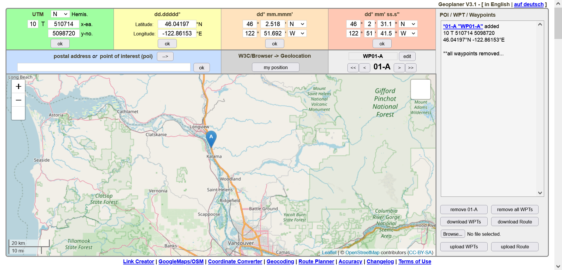
I am working in Kalama Washington USA
With the coordinate system I got from you it now takes me to the center of Oregon USA almost exactly center of the state
I know where Oregon and Washington is set you can use either UTM Zone 10 or 11
What CRS are you exporting out of DroneDeploy? When we need this kind of workflow we do everything in QGIS. You just import your ortho map and create points right on the map. Export that as a CSV to FGA.