


I created a survey project using Ellipsoidal height, when I should have downloaded and selected Orthometric height. Is there a way to convert Ellipsoidal height to Orthometric after I have already recorded the locations of several GCP’s? Can I do this in Emlid Studio? Thanks in advance…
1 Like
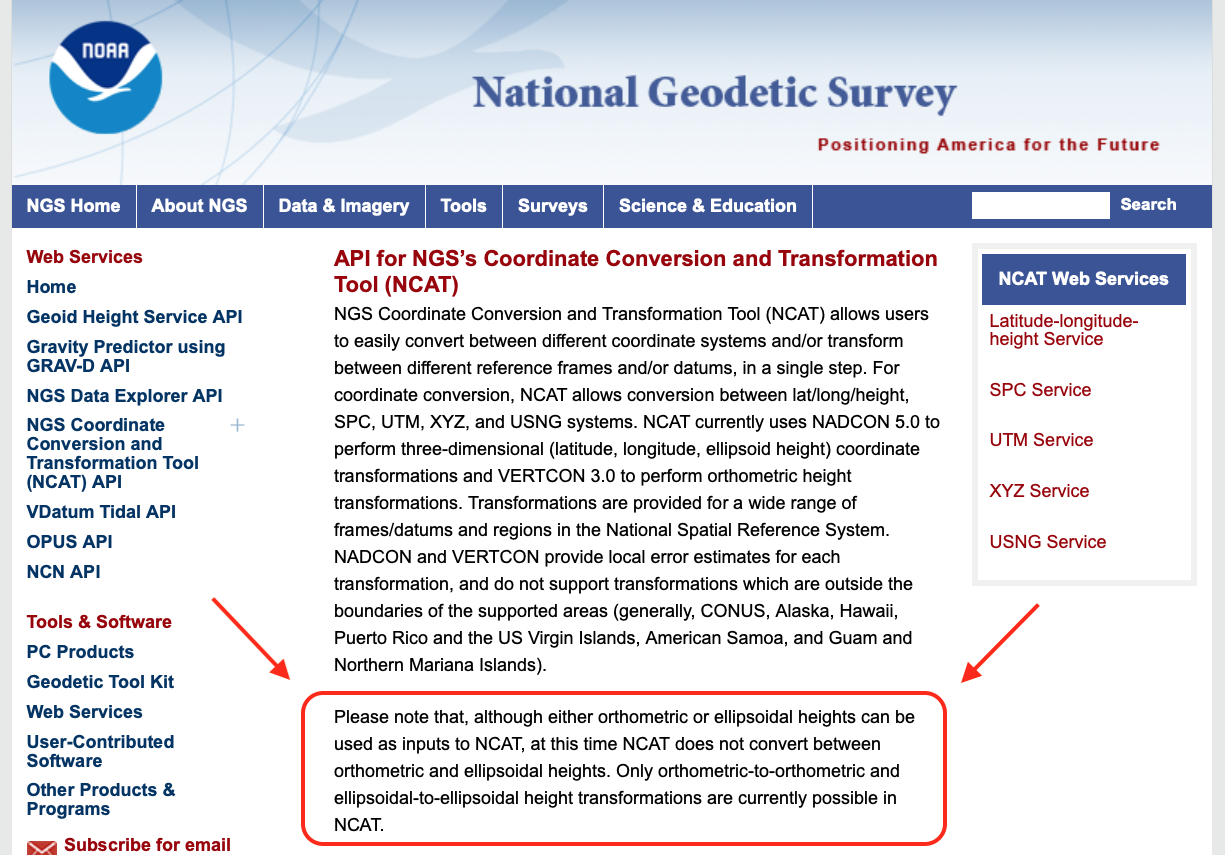
Multiple ways, but this site may help:
https://www.ngs.noaa.gov/NCAT/
I havent used Emlid Studio yet… so maybe someone can help there.
1 Like
Does that site apply only in the US?
Yes, I think so
1 Like
I am currently researching a software program called Corpscon, hopefully it will do what I need…
1 Like
Yeah, not sure then… I thought I used it at one point to do that… but maybe I used FieldGenius instead? Yeah, double check things ; )
1 Like
Not sure, as I use FieldGenius and not really Emlid Flow much… but wonder if you can export your ellipsoidal height collected points, create a new file with ortho height file, then import points into it???
I know in FieldGenius, you can try different ortho files and see the effect it has on ellipsoid height of the points.
1 Like
Thanks, I’ll give FieldGenius a look and a try.
In the US go here:
https://geodesy.noaa.gov/GEOID/GEOID18/computation.html
If your points are close - within a few km - the offset between ellipsoid and orthometric is essentially the same. Just shift them by xx.xxx meters. Whatever value the tool above gives you. If they are more spread out the tool will give you the correct offset at each site.
4 Likes
Thank You!
As jbonde002 said, use can use a single geoid height for the entire project if it’s not very large, however sometimes I use the batch command selection for all points if the site is large.
Using the batch command is easy and it can give good geoid heights just as the single input does. If you have a large number of points you can even see on a medium site (1000 ac) the actual resolution of the geoid18 model which is very cool.
3 Likes
Here is another awesome tool fyi (only does GEOID12B):
GEOID12B for Google Earth (earthsurvey.us)
1 Like
Thanks, someone else showed me how to use the free level of Emlid Flow 360 to do the conversion, so that’s what I’m going to use for now. It’s good to know there are a few (free) tools to do this.
5 Likes
It seems like you’ve found a workaround for converting heights in Emlid Flow, @dronemapper23. But let me share here the workaround so others can benefit from it too.
If Emlid Flow supports the geoid, you can convert it from Ellipsoid Heights by following the steps below:
- Download the CSV file from your project.
- Create a new project in Emlid Flow with the same coordinate system as your old project + geoid
- Import the CSV into the new project.
Once the CSV is successfully imported, the heights will be automatically converted to orthometric heights. This workflow is also applicable if you have geographic (global) coordinates that you wish to apply projection and geoid to.
5 Likes
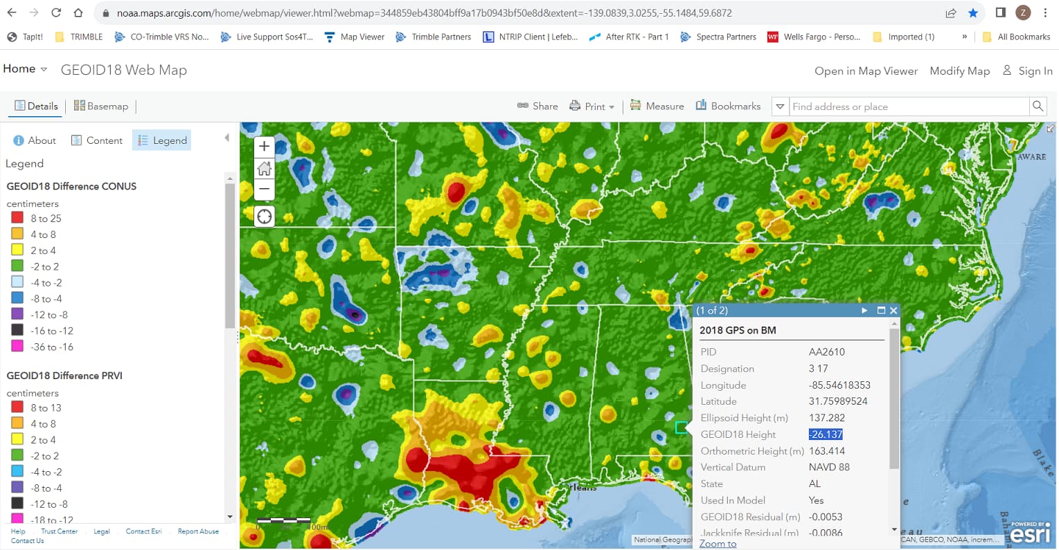
This is a good one but I would recommend using the NGS one. It’s a simply ESRI ArcGIS Online map and you can get the geoid separation value between the ellipsoid and Geoid 18: https://noaa.maps.arcgis.com/home/webmap/viewer.html?webmap=344859eb43804bff9a17b0943bf50e8d&extent=-139.0839,3.0255,-55.1484,59.6872.
The best way is probably just to import into emlid flow like you already mentioned @dronemapper23 .
4 Likes
To convert ellipsoidal height to orthometric height after the fact, you will need to use a geoid model. A geoid model is a mathematical representation of the Earth’s geoid, which is an equipotential surface that closely approximates mean sea level. The geoid model is used to calculate geoid heights, which are the differences between ellipsoidal heights and orthometric heights.
There are a number of different geoid models available, and the best model to use will depend on the accuracy required and the region of interest. Some popular geoid models include:
- Earth Gravitational Model (EGM96)
- Global Geopotential Model (GGM02c)
- North American Geoid Height Model (GEOID96)
- European Geoid Model (EGM96)
Once you have selected a geoid model, you can use it to calculate geoid heights using a variety of different software tools. Some popular software tools for geoid height calculation include:
- NOAA’s Geoid Height Calculator
- ESRI’s ArcGIS Pro
- NASA’s GeographicLib
To calculate the orthometric height of a point, you will need to know the ellipsoidal height of the point and the geoid height at the point. You can then use the following equation:
Orthometric height = Ellipsoidal height - Geoid height
For example, if the ellipsoidal height of a point is 100 meters and the geoid height at the point is 10 meters, then the orthometric height of the point is 90 meters.
It is important to note that geoid height models are not perfect, and they may not be accurate in all regions. Therefore, it is important to consult with a geodetic expert if you need to convert ellipsoidal heights to orthometric heights with high accuracy.
3 Likes
I’ve tried this but Emlid Flow does not keep the orthometric height. It changes it to ellipsoidal. How can I keep the orthometric height intact?
Hi @petehernandez,
Could you share a bit more about your workflow and why you need to convert it? Also, which coordinate system are you using?
I’d like to take a look at your files to better understand what’s going on. A screenshot or screencast would be helpful to understand the issue. Feel free to send everything over to support@emlid.com or share it here.
2 Likes
Even though PIX4Dmatic picks up the “ellipsoidal height” column in the .csv, I don’t think it converts it (automatically, anyways). The .csv out of Emlid Flow 360 starts out with orthmetric feet and I like to keep it that way once the coordinates are corrected so I can see the changes. Pix4Dmatic saw the ellipsoidal height as feet, not meters and threw off the model elevation inspite of labeling that column “Ellipsoidal Height”.
I had to manually take the corrected ellipsoidal height and subtract it from the geoid height at a given lat, long to get the orthometric height in meters (using this ellipsoidal to orthometric converter: GEOID18 Interactive Computation | GEOID | Data & Imagery | National Geodetic Survey, then from there I convert to feet. I wish there was an app that did this for me. Anyone know of a simpler way???
I’m using NAD83 / California zone 4 & NAVD88(GEIOD18) heights.
As far as the elevation changers, I believe that I hadn’t download the necessary GEOID18 file onto my phone. Mention of this need is buried deep in an Emlid doc. Apparently, I was making this Emlid Flow projects in the field where there was poor internet and the file never downloaded to my phone thus the poor elevation interpretation. Also, starting a new known point with OPUS solution from NAD83(2011) satellite helped.