How can I display the current coordinates of the RS3 Rover, while in Emlid Flow Survey, in my project’s units (feet) when I’m walking around a work site (e.g. while doing stakeout or simply shooting points for a project in a Global CS) without shooting a point and then doing a Stakeout to display that point’s properties? I know I can simply show the Status of the rover, but it’s elevation units are in meters but I’d like to see them in feet. Thanks
I have been thinking about the same thing. I feel like we had that ability before but can’t recall. Maybe when the USft CRS’s went away it stopped showing feet in Status? For a hack I wonder if you could make a 0 elevation surface and it would show you your elevation in cut?
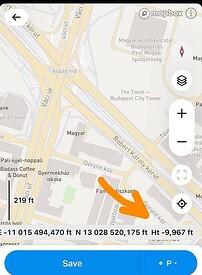
Should be in the bottom left hand corner of the map (where the averaging, etc is). Just swipe left in this area and you should see your ENZ move in from the right.
Thank you! Mystery Solved! That works great while in stakeout mode. Is there a way to display the ENZ when not in Stakeout mode?
Hi Steve,
If you scroll the panel with coordinates to the left, you can see real-time elevation in feet:
Is this work for you?
Yes! Thank you!
This topic was automatically closed 100 days after the last reply. New replies are no longer allowed.


