Hello
i work in electrical power lines design and i need to be able to do plans with centimeter accuracy.
so i acquired a RS+ and was thrilled that with NTRIP corrections from a paid base ~33km away and i as getting a decent accuracy: ± 5cm and lower.
BUT. i started to wonder if the stated accuracy is indeed true because i checked the points and seemed off. like a few meters off.
here is an example:
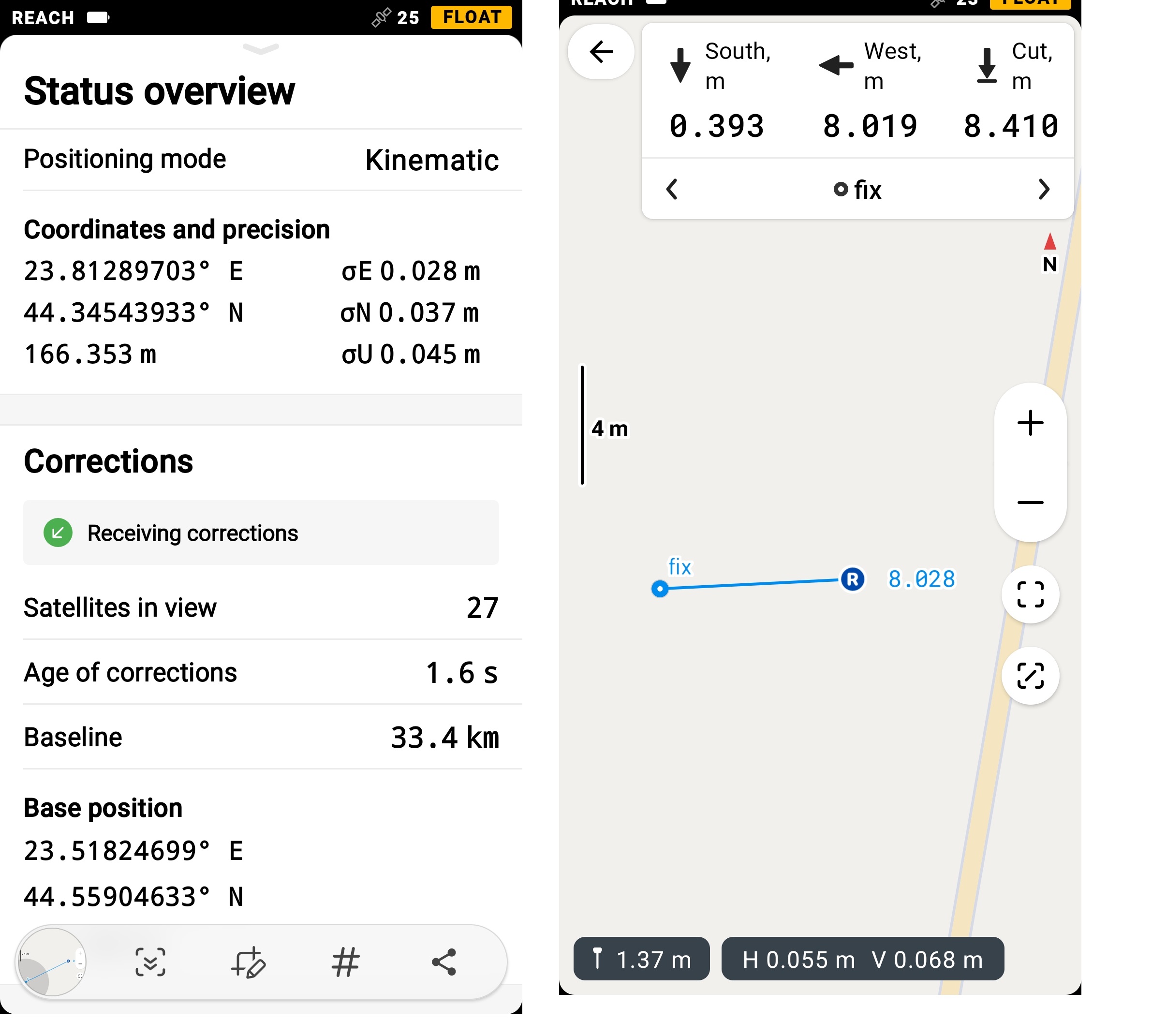
i got a point with FIX (±1cm accuracy).
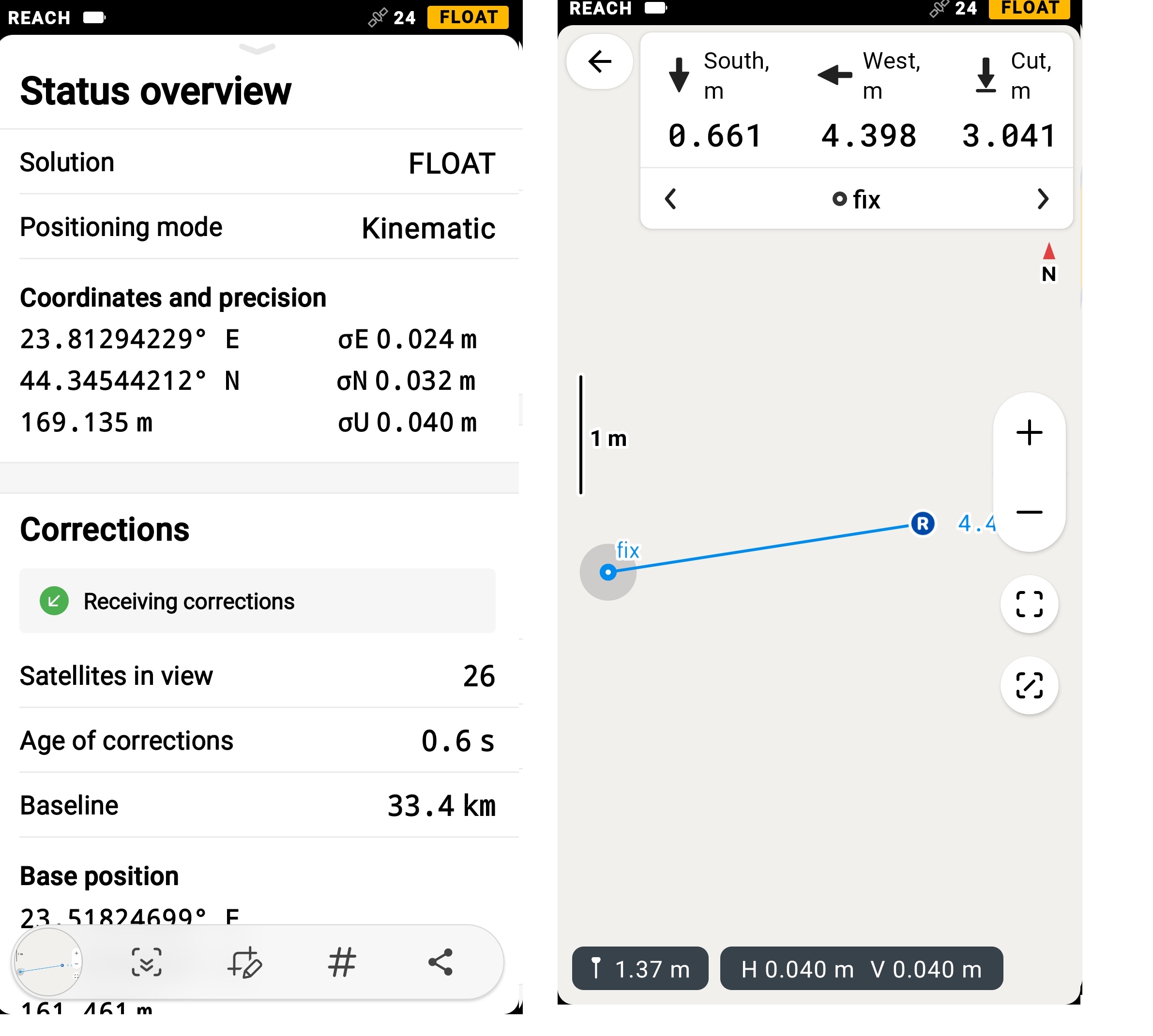
i checked the same point in Float, not being able to get a fix, but with less than ±5 cm accuracy.
the results, in stake mode? 4- 8m off! that seems pretty unusable to me.
is getting a fix a must?
Hello Victor,
already for the RS+ receiver (single frequency the theoretical precision and in the best conditions in RTK is :
Kinematic horizontal : 7 mm + 1 mm for each km.
In your case = 7 mm + 33 mm = 4 cm.
Kinematic vertical : 14 mm + 2 mm for each km.
In your case = 14 mm + 66 mm = 8 cm.
On the other hand to keep the centimeter precision, a single frequency is limited to 10 km in RTK and 20 km in PPK.
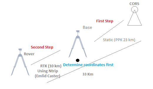
In your case and if you have a second receiver I suggest you to do a static with the base first with a point whose coordinates you will determine not far from 23 km and from this point you will use the RTK mode (NTRIP using the EMLID Caster for example) to do your work like the diagram below.
There are two points. One of them is already described by Zinedine, but I’ll double it too.
Firstly, Float solution can’t provide you with centimeter-level accuracy. It’s usually sub-meter or meter-level. The trickiest thing here is that one time it can be 10cm and another 1 meter. So, the Float solution isn’t something you can rely on. I highly recommend working with a Fix only.
Another thing here is that the maximum baseline for single-band device in RTK is 10km. When this limit is exceeded, it may report centimeter-level accuracy, but that’s not true. The maximum baseline is set up because RTK algorithm allows calculating precise coordinates assuming that base and rover data are affected by the same atmospheric errors. On baselines larger than 10km, the algorithm still assumes the same atmospheric conditions, which in fact are different. It leads to accuracy issues.
So, if you don’t have a closer NTRIP base, it’s better to place your own to obtain the best results.
Single-band devices indeed need some time to calculate a Fix. But it really depends on the conditions. If nothing blocks the sky view, it takes just about couple of minutes. If there are some obstacles, it can take more.
If there are a lot of trees or buildings on a site, multi-band devices handle it better.