I’ve been trying to get fixed solutions for my rover points using a PPK solution. my issue is that only 1 point was able to be ‘fixed’ and i am not sure why. i noticed that the RMS and PDOP readings for the one fixed point lower than the other ‘float-only’ points . I wonder if I am not waiting long enough when getting capturing each point, or if there is a setting i am missing.
This work is being done using the Emlid Studio, Stop and Go with RV3.
Thank you for the files you shared. But I am afraid I couldn’t find the raw data logs from the base and rover. It seems that the folders where this data should be are empty. Could you please check again and add them? Then I can check the quality of the logs and try to reproduce your issue.
Tried processing your files in Ez-Surv and in Emlid Studio. EzSurv is usually quite conservative, this time no exception, all points in float.
Processing in Emlid Studio gives me point 1 and 2 in fix (in fix&hold mode, 1 in fix in Continous mode), but no stdev info, so no idea about the quality of the fix.
I see that you are in some pretty difficult conditions for GNSS in general. Your 20s obs-time per point is, in my opinion, not long enough. In those conditions you are looking several minutes, basically making sure that give the unit time to fix ambiguities from scratch on each point. Try 5 minutes.
As Christian said, in difficult environments 5 minutes is a minimum. Personally, I would observe no less than 15 minutes. I’d also re-observe the point to verify the first observation. If you don’t get a reliable fix, at least you’ve got enough data to PP. Hopefully, your baseline length is short. Short baselines and time on station are your friends in the GNSS world.
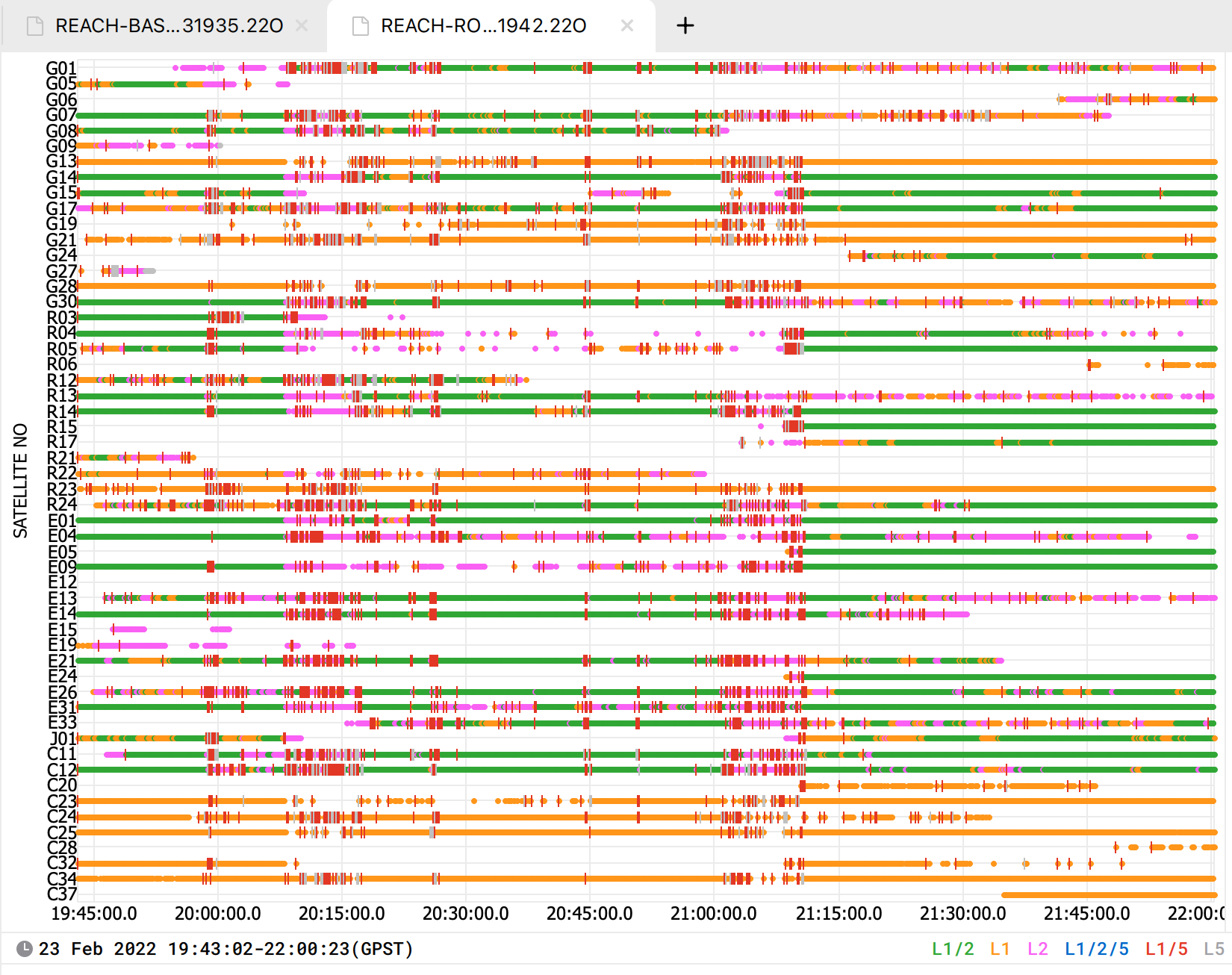
From the log, it looks like something affected all the satellite signals. For example, powerful radio-electronic sources and high-voltage lines nearby generate an electromagnetic field that can affect signal stability. This may be the reason why you can’t get a Fix for all your points. You can check the placement requirements for more detail.
It would also be great if you could describe the environmental conditions in which the rover worked. This will help me to determine what’s happening more precisely.
Hi Elena, the area was in a more densely forested area on a steep drop off. the first few points were taken at the top of the ridge line with no direct overhead trees/canopy cover and a claer view with 30 degrees above horizon. The other points were in 20-30% canopy cover and along the cliff area and on the beach (with the tide out). These points were taked in less than ideal location. I think combined with what others were saying about too quick a measurement time (20s) and in less than ideal areas, is probably why I could not get a fix. Thank you for looking into this!
Thanks for the clarification, now it seems to make sense.
I guess that the rover was in places with dense foliage at the time when the satellite signals had a lot of cycle slips. Since GNSS signals are weak enough, the heavy canopy may disturb the signal reception. That’s why I can’t say for sure if standing on the point for a longer time can help in such conditions
You could also try raising the receiver higher. Or, if you don’t need to collect a specific point in the forest, it may be better to get out into place with a clearer sky view. However, we usually recommend using non-satellite survey methods as a total station in the area with dense foliage.
Hola, bajo mi experiencia estimo que sería bueno combinar las mediciones con otros equipos de reflexión directa (estación total con rebote), te ahorrarás tiempo… Dejas un punto fijo donde calar el equipo; y vas midiendo sectores despejados con gnss en ppk, y el resto bajo follaje con rebote.