


I’m new to ppk processing, followed the guide https://docs.emlid.com/reach/common/tutorials/analyzing-logs/.
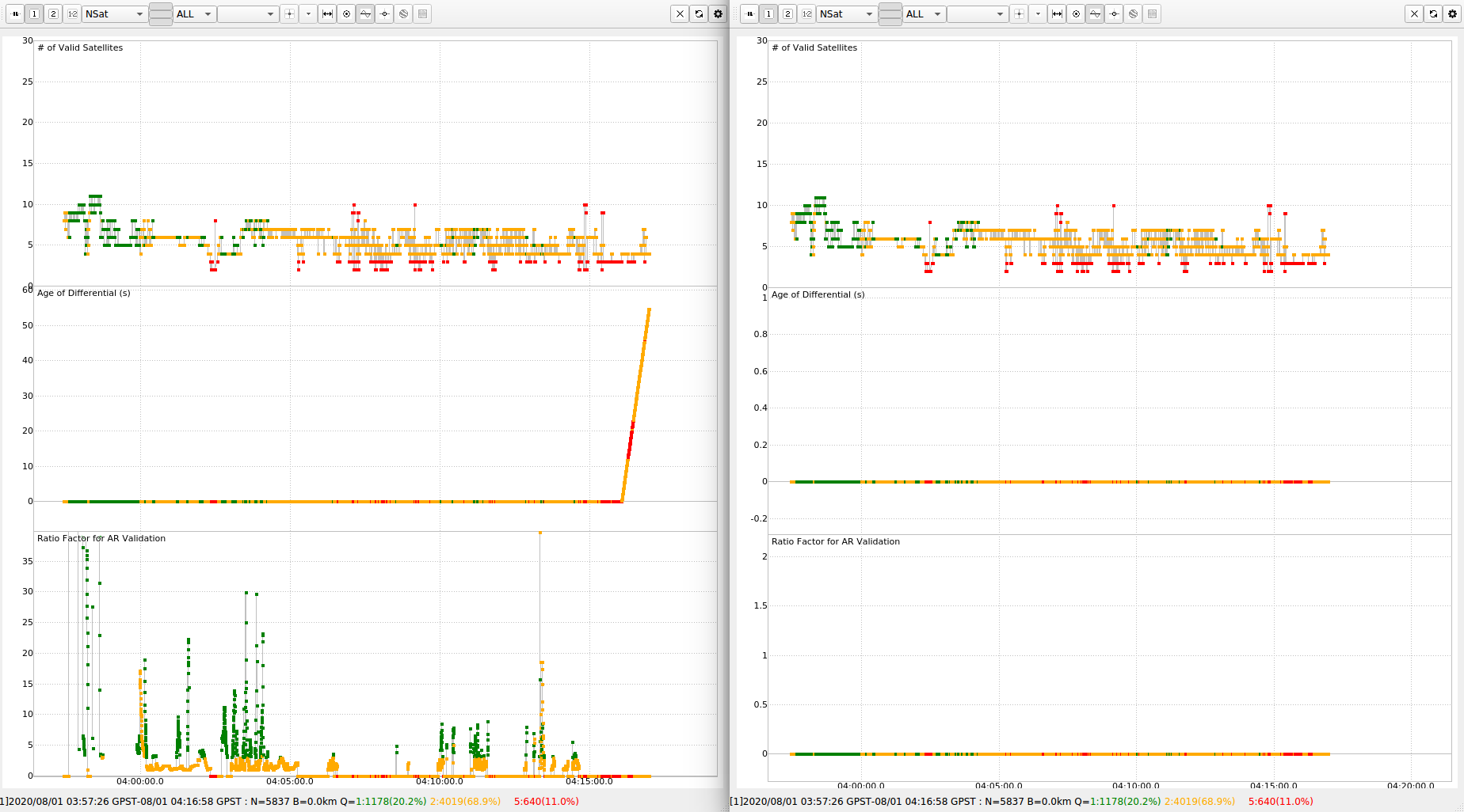
When I set output format to ‘LLH’, towards the end of log, age of differential spikes to ~50 sec. (max age of diff set to 60(default))
when I set output to ‘nmea 0183’ , the age of differential is nearly zero through out the data.
Even, AR ratio plot looks different.
Is it a bug or am I doing something wrong ? Would this affect the accuracy of data in any way ?
thanks in advance.
LLH output files
raw_202008010357.pos (821.8 KB) raw_202008010357_events.pos (1.0 KB)
nmea 0183 output
nmea_out.zip (3.5 MB)
filter used: ‘combined’
snr mask: same behavior with and without mask.
left side is LLH format in .pos file and Right is nmea 183 format.
config_files_both.zip (3.4 KB) config file:
rover_data rover.zip (1.6 MB)
base_data : file is too big, uploaded all files on this google link.
https://drive.google.com/drive/folders/1Tn8w0xHhbYhShat1JoPDhIm5f9XH_a5A?usp=sharing
Bug Report format:
- Firmware image and ReachView version.
- reach-rs-v2.22.5 firmware, (current /latest reachview app as of 2020-07-31, probably 2.22.5)
device: emlid reach. (BASE and ROVER)
rtklib version: Emlid rtklib ver2.4.3 b33 downloaded from https://docs.emlid.com/reach/gps-post-processing/
- don’t have device with me right now, I’ll try to upload if someone requests it.
- Detailed problem description. How does observed behavior differ from the expected one?
- I tried ppk using emlid’s rtklik b33, the age of differential goes to ~50 seconds towards the end of log, If I use LLH format, it stays near zero if I use nmea 183 format. Any idea why it might be happening ? other than that rest of plots look same to me.(forgive my untrained eye in ppk processing)
- Your step by step actions.
data collection :
4.1.1 fixed base on tripod with Aluminium ground plane;
4.1.2 Rover is UAS doing survey pattern at 1-1.8 m/s, rover antenna is placed on top of metallic (probably Aluminum not completely sure) uas battery compartment (dji matrice 100) without ground plate that we generally use( for the base). As metallic battery compartment raised above uas surface could serve the same purpose.
4.1.3 In Field, on rover I reduced the snr to either 20 or 25 on reach app with elevation angle set to15 deg, in order to increase the number of sats used and to acquire single fix status. while base had snr of 35. As I was logging raw data for ppk, does snr set in reach app affect my postprocessing ? (I wasn’t using this gps data for navigation, just used it for logging)
rtk Post
- load config file, load base, rover files in rtkpost, hit execute, hit plot > look at nSat from drop down menu.
the args used in rtkpost are::
rover obs
<path_to_dir>/raw_202008010357_RINEX-3_03/raw_202008010357.obs
base obs (using , all base files from aug 31 7:30 am(EDT) to SEP 1 00:30 AM(EDT) are used)
<path_to_dir>/ppk/base/data/raw_20200.obs
other files
- base nav <path_to_dir>/ppk/base/data/raw_20200*.nav
- base sbs <path_to_dir>/ppk/base/data/raw_20200*.sbs
- rover nav <path_to_dir>/raw_202008010357_RINEX-3_03/raw_202008010357.nav
-
Picture of the setup and connection scheme.
na -
If you are reporting an issue with solution, please provide RTKPLOT of observations from rover and base (with all the systems enabled and LLI flag for cycle slips). Instructions can be found here.
- check attachments.
- Attach RINEX log files for rover and base. If you prefer to keep them confidential, you can email the files to support@emlid.com with a link to the thread. Please note, that in this case, other community members will not be able to help you.
-check attachments