I am using GeoSetter to tag photos from a drone mapping mission. A number of the photos are tagged with the wrong geolocation and I am looking for help troubleshooting this problem.
Equipment and workflow:
Camera is mounted on a drone and triggered at 1 second intervals with a reach M+.
Camera events are recorded by the M+ using a hot shoe adaptor.
This set up was used to conduct mapping mission of an agricultural field.
The full mission included two battery changes during which the drone returned to the home point and landed. Photos continued to be taken during battery changes.
Raw logs were downloaded from the drone mounted M+ and RS+ base station and processed in Emlid Studio. (I know Emlid Studio is in beta, but this doesn’t seem to be where the problem is. Can re-run in RTKLIB if recommended).
events.pos file has the same number of events as the number of photos that were taken, with events at ~ 1 second intervals.
The first part of the flight was float, but the bulk of the flight was fix.
events.pos file was converted to GPX using RTKPOST.
GeoSetter was used to tag photos with their locations.
Discovering the problem:
By looking at the photos I removed (moved to a different folder) those that were taken during takeoff and landing.
Photos that were taken during the mapping part of the flight were loaded into pix4D for processing.
I noticed that photo markers were missing for a portion of the flight. By clicking on photo markers I was able to see that the images did not match the locations.
I also loaded the photos from takeoff/landing into a pix4D project and they showed the missing mapping locations, but the image was clearly taken from the ground.
Some photos from the main flight seem to have been tagged with locations near takeoff and landing, and photos from takeoff and landing have location tags that put them in the middle of the mapping area.
There are event positions that show up in the event.pos file when viewed in Emlid Studio, but there does not seem to be pictures that were tagged with those positions.
When I view the event.pos file in google earth, the photo locations look correct.
Does anyone have any suggestions for how to fix this or find out what is going wrong?
An explanation of how GeoSetter matches photos to locations would be helpful.
Do you have any recommendations for tools that will let me troubleshoot this better? I would like to be able to view photo locations on a map, see the photo when I click on it and see time stamp information.
Thank you for such a detailed description of the issue.
I’ve conducted a test with our dataset but couldn’t reproduce the issue you face. Could you please tell me if you use the same settings as described in our guide? We tested these settings and can confirm they work fine.
Also, please upload the whole dataset, including the photos collected on the ground, to photogrammetric software and share a screenshot with me. Since photogrammetric software allows you to see the position of the photos in 3D, it provides more illustrative information in comparison to GeoSetter.
An explanation of how GeoSetter matches photos to locations would be helpful.
As I know, GeoSetter matches the coordinates and photos by order, so there shouldn’t be any issues from this side.
I added another set of screenshots to the drive folder shared above showing a pix4d project with all images, as well as screenshots of my settings in geosetter. Let me know if that gives you the information you need.
I am pretty sure I followed all of the settings in your guide the first time around, but I decided to re-do the process just in case. Screenshots showing all of my settings are in the drive folder. I had better luck for this second attempt, but still had a few weird location tags. This time four of the points had negative latitudes. In the image properties editor in pix4d I deleted the negative signs for the latitudes of these points. This moved them much closer to their correct locations, but now they are 2 drone flight passes over (see screenshots). The problem images are spread through out the flight.
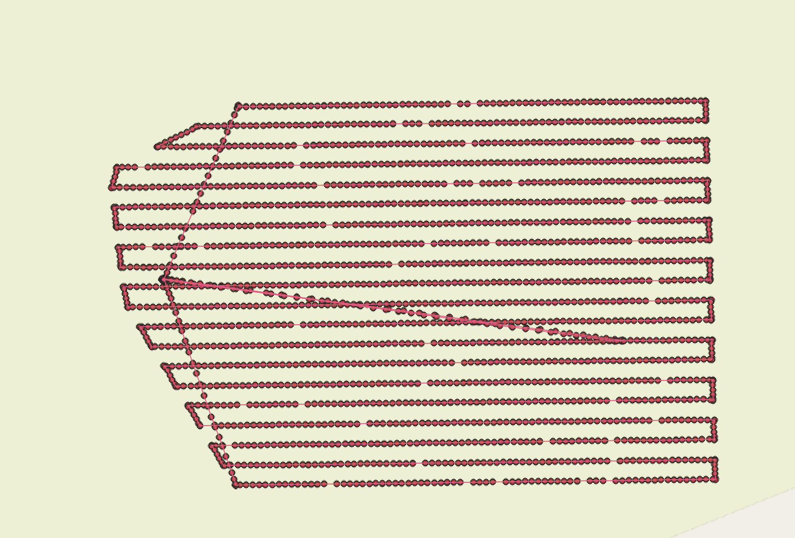
I converted the events.pos and events.gpx files to .kml and opened them in QGIS to check if the positions were shown correctly at this step. It seems that everything is fine:
For now, it looks like the issue occurs at the GeoSetter stage. GeoSetter is a 3rd-party app, so I can hardly comment in detail on how all the settings chosen in your test could affect the solution. We used standard settings for our tests, and the data was processed fine.
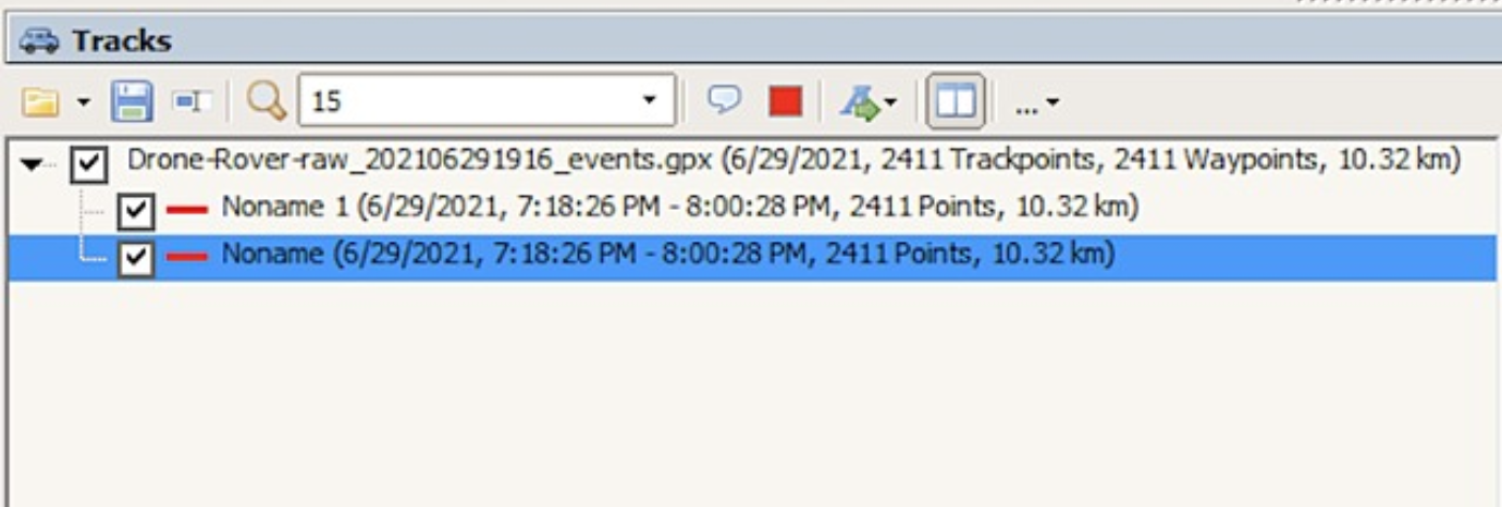
I’ve noticed that when you uploaded the events.gpx file to GeoSetter, it was identified as 2 tracks, not a track and waypoints as in our guide:
I converted your events.pos file to events.gpx in our version of RTKLib to check if something might go wrong at this step. When I uploaded the obtained events.gpx to GeoSetter, it was shown as 2 tracks as well. It’s hard to say if it may influence any GeoSetter algorithms, but it looks unusual. I’ll discuss your case with the team and get back to you.
Thanks for looking into this! I agree that the problem seems to be in GeoSetter. I am working on other methods of geotagging the pictures (exiftool, python). I’ll write back when I have something to report.
I’ve double-checked the data from Reach and haven’t noticed anything unusual that can lead to improper geotagging. You may consider discussing the issue with the GeoSetter support to find out what can be wrong. We’ll also try to contact them regarding this issue.
If you had a chance to try other geotagging methods, I’d be glad to know if the data can be processed fine these ways.
I used exiftool to get a csv with the file names and time stamps from the photos, and copied and pasted in the data from the events.pos file. Using excel I checked that the time stamps from the exif data matched the timestamps from the events.pos file, and formatted the csv file to match the pix4d requirements.
Thanks for coming back with an update! Yes, this workaround is possible, although it can take some time to accomplish.
We still haven’t received any update from the GeoSetter support. We’re working on possible solutions which can simplify the workflow of mapping and geotagging.
I’m back with the great news about the latest release of the Emlid Studio. We’ve implemented a geotagging feature with a simple workflow in Beta 9. I suggest you try it by yourself and share your thoughts on it: