


Please add geoid egm08 for Ukraine, or how i can add it myself?
EGM08 for latitude 44-53 degrees and longitude 21-41 degrees.
Hi Nykodym,
I’ve just checked that the EGM08 geoid is avaliable as EPSG:3855. Are there some issues with the Ukraine region in particular?
i will check it.
There are no in list of geoids “EPSG:3855”.
here is geids for Ukraine. I think they all similary. I think better fo use it “EGM08_2000_UA.bin” in folder Digitals.
https://drive.google.com/drive/folders/11JonFcl2LC1c4R3P0DPESz8_0s8IIVB1
What coordinate system did you choose? It may limit available vertical datums as well. Can you share the screenshot?
I’ve checked the “EGM08_2000_UA.bin”. As EGM08 is a global geoid, this file seems to be just cropped by your region. But I’ll take a closer look.
I use USK2000 6zone. But there are 2 type of 7 parameters for different RTK opereators. They all send RTCM message number (type) 1027 and 1028, but your application can`t recieve it.
1st type of 7 parameters, i named it 2000free, it use by rtk operators zakpos (most popular in west regions), tnt-tpi, spacecenter.
2nd type of 7 parameters, i named it 2000sysNet, it use by rtk operator systemnet only.
another is identical (only not geoid).
When i don`t know 2nd type of 7 parameters, i use 1st type for rtk from systemNet(most popular) and use also offset near 0.83m.
see here

But is official 7 parameters, they was a year ago identical as 1st type.
But now they + 24.322 m; – 121.372 m; – 75.847 m; 0;0;0;0 - not like 1st type or 2nd type.
I don’t know why, I don’t test it. Maybe they well for some RTK operator.
see here
https://dgm.gki.com.ua/pasporti-derjavnoii-geodezichnoii-referencnoii
https://dgm.gki.com.ua/files/image/3261067/Pasport_UA_UCS-2000%20to%20ITRS_ITRF2000.pdf
I understand that all geoid with grid 1x1 minute for same territory and for EGM08 must be identical.
But can you add also geoid from folder “zakpos egm08”. There are grid 1x1 minute AND 15x15 sekonds.
I test in work on computer in geocalculator “EGM08_2000_UA.bin” - it work fine with rtk operator systemnet (it use 2nd type of 7 parameters). I took virtual point and calculate it with local geogalculator which use “EGM08_2000_UA.bin” and with geocalculator on web site of rtk operator systemNET. Difference was 0.075meter.
In appliacation NUWA Tersus i test from folder “rusgeocom_ru” *.ggf - the differents from real 2 points was -0.1m and -0.13m.
I want add geoid by himself, please add this function ![]()
Oh, I see you use the Custom coordinate system feature. I understand your request. But just want to sum up:
-
Is the geoid model from the “zakpos egm08” folder the same as EGM08 but with better resolution and cropped for Ukraine?
-
Have you checked the EGM08 models available in ReachView 3? I understand it would be easier for you to add the needed geoid yourself, but it may not be easy to handle from the app side. So, for now, we can add this geoid for you. So, I want to make sure we won’t add similar models. That’s why I’m asking.
This is also a good request. I’ll note it if you don’t mind ![]()
1 Like
Is the geoid model from the “zakpos egm08” folder the same as EGM08 but with better resolution and cropped for Ukraine?
YES, there to geoids grid 1x1 minute AND grid 15x15 sekonds (bigger file).
NO, i do not do it. How you think which of this geod i must use for Ukraine?
It to hard make new progect for each geoid, i can`t change geoid in an existing project, i must make new project and make new system coordinate in each time if i want to change someone.
There are no function to dublicate system coordinate or to dublicate project whith some changes.
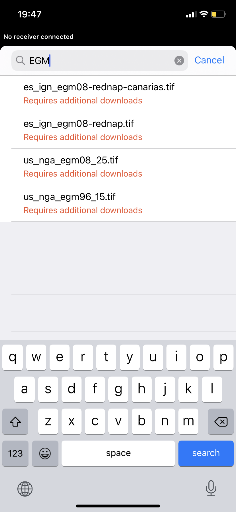
I know that geoid egm08 on all word occupies the size near 900Mb. I don’t think that there are geoid fro Ukraine. They occupies to low size.
Please write what geoid i must to test? But i think it has no meaning.
Maybe you have not costom coordinate system for USC2000/Ukraine?
“us_nga_egm08_25.tif” should work for you. It has a lower resolution than the one you shared, but the final heights shouldn’t differ more than several millimeters.
If the results are poor, let me know. I’ll help you.
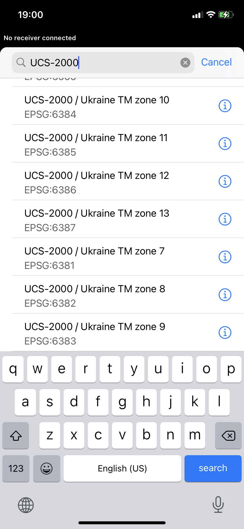
We have several zones available:
But from your description, I see that they most likely don’t help. However, 1027 and 1028 RTCM3 messages support may solve cases like yours. I’ll discuss it with the team.
1 Like
About image, i don’t understand what mean this 7 zones from 7 to 13.
It don’t USC-2000.
It dont have 7 parameters. They look like local USC-2000 for each of 27 region (2 regions now full occupied). But i and another dont use local USC-2000, i use global USC-2000.
It have 4 zones for Ukraine (for UA: zones №№ 4, 5, 6, 7). See here https://dgm.gki.com.ua/files/image/3261067/Description_of_CRS_UA_UCS_2000_GK_6.pdf
I give you screan with 7 patrameters which work fine with reachview 3 in plane, not in HEIGHT. I test it in field.
I understand where you took this.
1)USC-2000 have 6 degree zone, and total for Ukraine 4 zones named № 4, 5, 6, 7.
2)USC-2000 have 3 degree zones, and total for Ukraine 7 zones named № 7, 8, 9, 10, 11, 12,13.
I don’t know anyone who use 3 degree zones, but your zones don’t have 7 parameters.
3)USC-2000 have 27 local zones for each region of Ukraine.
People use or 6 degree zone, or local zone.
USC-2000 have ideal solution with wgs84 on all territory of Ukraine. One moment you must input correct 7 parameters.
Hi Nykodym,
These coordinate systems were taken from the EPSG database. It contains coordinate systems for many countries, but not all of them are indeed used there. In such cases, we add coordinate systems by requests from users.
As I see, in Ukraine, RTCM3 messages with parameters are commonly used. So, we’ll be working on that. If you’d like to, I’ll notify you once this feature is avaliable.
1 Like
I work fine now well without RTCM3 1027-1028. If i work in USC-2000 you don`t need it and if you don’t need true height. I think so work near 2-5% of users.
I will test geoid “us_nga_egm08_25.tif”.
Please add my geoid at first. I want possibility to add it myself, please.
Sure, I’ll be waiting for the results of your tests. I’m pretty sure this geoid should work for you. If it’s not, I’ve saved your geoid so that we can check how to support this in ReachView 3.
1 Like
Hi Nikodym,
How is it going? Have you had a chance to check your workflow with us_nga_egm08_25.tif geoid? Is it working well for you?
I don`t have time yet to test us_nga_egm08_25.tif geoid
Nykodym, got you! Feel free to get back to us once you have 
Thank you for help. It work for me. I test it on different 3 point - 5km max distance between it. And difference was +5 to +60mm on all equally. Mainly it was +30mm on all points. I don`t use tripod and my hand influenced the result.
Thank you, it is great result!!!
2 Likes