


Hello everybody! I need your help. Can you explain me or send me instruction how to find places on earth with known coordinates using my emlid rtk gps single mode? It will be better if you send me video instruction (of course in case if it exists😃).
Thank you for your attention! 
Google Maps would be the perfect choice. You just have to input the longitude and latitude of the point and then the location of the point will be presented on the map.
Sorry you have some misunderstanding. I know coordinates that I have taken from the map. Then I went, for example, in the fields and I want to find where this place is. How can I input this coordinates into the gps and find this absolute point?
Which Emlid equipment do you have?
Which version of ReachView is running on it?
Emlid reach rtk gps. Reach view is 2.18
This is the type you have, correct?
And you have just 1 unit and plan to operate it in single mode for stakeout of points?
(i.e. going to specific coordinates)
If so, then your accuracy could only be as good as 2.5m - the same as any other GPS. And that accuracy is if you average your position for a few minutes using the survey mode and doing ‘collect point’. If you don’t average your point, the accuracy could be worse.
But operating in single mode is not the intended use for Reach GNSS receivers. To get centimeter accuracy in real-time for stakeout operations, you would need 2 units operating in RTK mode with a live communication link between them (via radio or Wi-Fi/Internet).
1 Like
OK. Thanks
And can you tell me how I can import points manually? Are there any special rules? What format does it need? Can you give me an example?
Hi Giorgi,
In the meantime, we don’t have a video tutorial for points steakout. However, you can follow a text guide: Point steakout.
Reach supports CSV, GeoJSON, and DXF formats, also you can enter coordinates manually.
2 Likes
But there is nothing written about manual importing. I need to know what special format it needs and how to do it. Also there is a problem with importing CSV. Isn’t it possible tu upload file by using android phone? When I click on that button nothing happens
May I ask you to share the screenshot describing this situation?
@Giorgi_Shatirishvili
You have to paste and follow this format :
name,longitude,latitude,elevation
Point 1,30.339,59.958,53.618
Point 2,30.334,59.960,58.944
the first line name,longitude,latitude,elevation as it is is required!!
2 Likes
Is this manual importing?
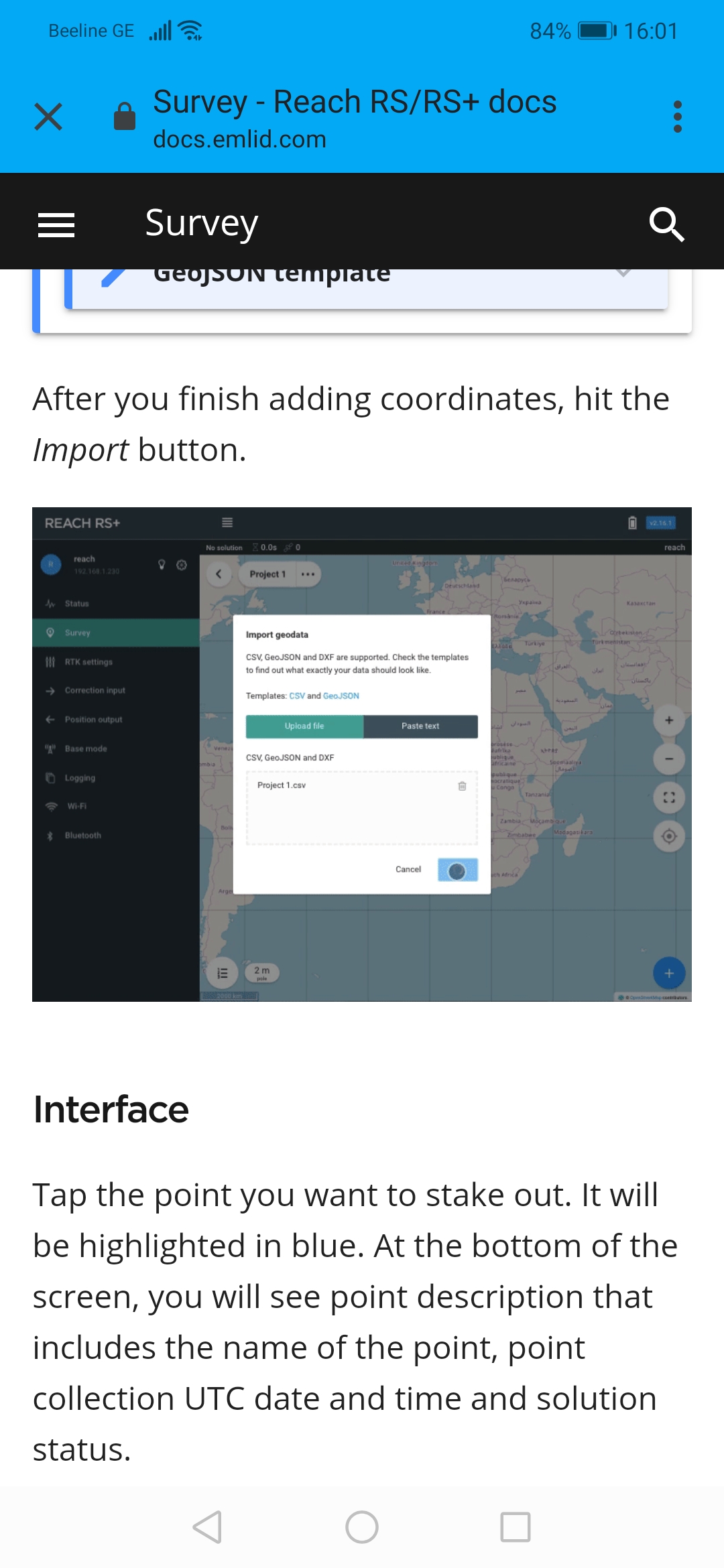
I have csv file in my phone which I have made according to the rules. But when I click on the field there doesn’t open anything from where I can choose this file and import it to the software. I know that it can be done with computer but I want to do it by my phone. ( I ha e taken this picture from the instruction you have sent)
Thanks!
May I ask you to connect to Reach using its IP address (you can find it in ReachView) using the browser? There you can also find the Survey tab and upload a CSV file.

I got your advice and it worked. I inserted file bu opening programme in browser. But when I inserted it and pushed import it started processing for a long time. I had been waiting bat in vain and then turned it off. What can I do?
This is what my csv spreadsheet looks like. It is made with Google spreadsheets.
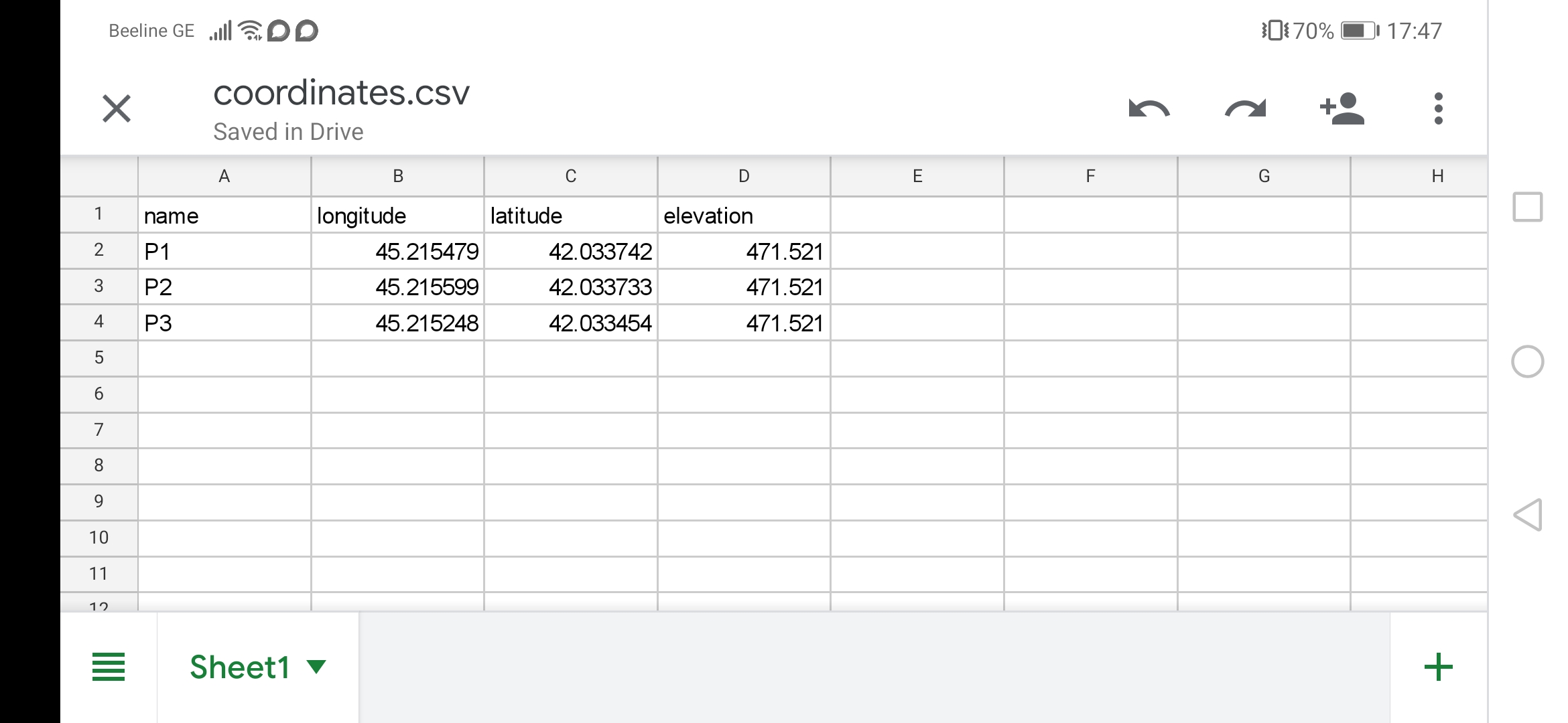
name,longitude,latitude,elevation
P1,45.215479,42.033742,471.521
P2,45.215599,42.033733,471.521
P3,45.215248,42.033454,471.521
Try this one unzip and import
Coordiantes.zip (246 Bytes)
Hi Giorgi,
May I ask you to try uploading the file suggested by Zinedine?
This topic was automatically closed 100 days after the last reply. New replies are no longer allowed.