Feedback on elevation accuracy

First of, I am not a surveyor but wanted to learn surveying techniques on my own. My background is structural engineering and I am semi retired and had a nag for surveying and new technology. So I bought the EMLID RX for fun.
My first project was to check TE USGS elevations based on the NGS datasheet in southeast Michigan, USA. The data sheet states tha the NAVD 88 ortho height is 680.1f ft of this survey monument.

ROGRAM = datasheet95, VERSION = 8.12.5.17
Starting Datasheet Retrieval…
1 National Geodetic Survey, Retrieval Date = MARCH 28, 2024
MC0777 ***********************************************************************
MC0777 DESIGNATION - Q 114
MC0777 PID - MC0777
MC0777 STATE/COUNTY- MI/MONROE
MC0777 COUNTRY - US
MC0777 USGS QUAD - DUNDEE (2017)
MC0777
MC0777 CURRENT SURVEY CONTROL
MC0777 ______________________________________________________________________
MC0777
NAD 83(1986) POSITION- 41 54 13.01 (N) 083 40 16.47 (W) HD_HELD1
MC0777* NAVD 88 ORTHO HEIGHT - 207.306 (meters) 680.14 (feet) ADJUSTED

I set up my RX based on my understanding of the procedures and went to this point and took a reading, saved it and sent as DXF file.

this is what shows on the DXF file
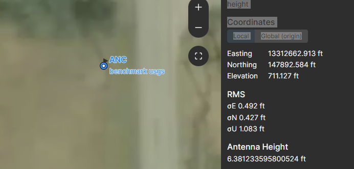
Coordinates

LocalGlobal (origin)

Easting13312662.913 ft

Northing147892.584 ft

Elevation711.127 ft

RMS

σE 0.492 ft

σN 0.427 ft

σU 1.083 ft

Antenna Height

6.381233595800524 ft

Collection Time

Start:28 Mar 2024 • 12:23:36

End:28 Mar 2024 • 12:23:36

Duration:00:00:00

Samples:1

I am trying to understand why my reading was 711.127 while the datasheet is showing : 680.14.

Thanks and like i said, I am still learning my way around this so I appreciate any feedback you can provide.

Are you using a correction service (NTRIP provider) with your RX?
Also, you should observe for longer, at least 5 seconds.

2 Likes

When u set up your new project file, did u setup matching coordinate system to the data sheet and NTRIP provider ALONG with the GEOID file of your region to get correct orthometric height?

2 Likes

Your observation time is 0. Was the unit using an RTN service ? Per the datasheet, the horizontal position was determined only by “handheld” unit. This usually means the accuracy is at best 3 meters. Per the datasheet this is only a vertical passive mark, class 2 accuracy determined by differential leveling.

https://www.ngs.noaa.gov/cgi-bin/ds_mark.prl?PidBox=MC0777

You need to set up to your states projection with the Geoid18 model. You’ll be determining the horizontal position as well as verifying the vertical component. Observation times if using an RTN service should be a minimum of 10 minutes. You should revisit the mark 24 hrs later and reverify with same observation time.

Static observation should be a minimum of 60 minutes depending on baseline lengths from an operating CORS station.

These are our firm’s procedures for verifying existing passive control marks. You can read this here for more info if you are planning to submit data to NGS OPUS for static processing

https://geodesy.noaa.gov/OPUS/about.jsp

2 Likes

Hi @ges734,

Welcome to our community!

Did you use an NTRIP service to provide your Reach RX with corrections? If yes, which service did you use?

As @timd1971 mentioned, to compare coordinates, they should be in the same coordinate system. Is your project also in NAVD88?

1 Like