First of, I am not a surveyor but wanted to learn surveying techniques on my own. My background is structural engineering and I am semi retired and had a nag for surveying and new technology. So I bought the EMLID RX for fun.
My first project was to check TE USGS elevations based on the NGS datasheet in southeast Michigan, USA. The data sheet states tha the NAVD 88 ortho height is 680.1f ft of this survey monument.
ROGRAM = datasheet95, VERSION = 8.12.5.17
Starting Datasheet Retrieval…
1 National Geodetic Survey, Retrieval Date = MARCH 28, 2024
MC0777 ***********************************************************************
MC0777 DESIGNATION - Q 114
MC0777 PID - MC0777
MC0777 STATE/COUNTY- MI/MONROE
MC0777 COUNTRY - US
MC0777 USGS QUAD - DUNDEE (2017)
MC0777
MC0777 CURRENT SURVEY CONTROL
MC0777 ______________________________________________________________________
MC0777 NAD 83(1986) POSITION- 41 54 13.01 (N) 083 40 16.47 (W) HD_HELD1
MC0777* NAVD 88 ORTHO HEIGHT - 207.306 (meters) 680.14 (feet) ADJUSTED
I set up my RX based on my understanding of the procedures and went to this point and took a reading, saved it and sent as DXF file.
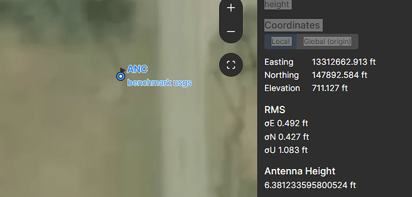
this is what shows on the DXF file
Coordinates
LocalGlobal (origin)
Easting13312662.913 ft
Northing147892.584 ft
Elevation711.127 ft
RMS
σE 0.492 ft
σN 0.427 ft
σU 1.083 ft
Antenna Height
6.381233595800524 ft
Collection Time
Start:28 Mar 2024 • 12:23:36
End:28 Mar 2024 • 12:23:36
Duration:00:00:00
Samples:1
I am trying to understand why my reading was 711.127 while the datasheet is showing : 680.14.
Thanks and like i said, I am still learning my way around this so I appreciate any feedback you can provide.


