@kirill.pavlyuchuk I would like to echo/reiterate the importance of being able to geotag TIFF images. Coming from the USGS and now with a research unversity, we purposely image in RAW and TIF formats because of the image quality and bit depth. It’s important that we don’t have to downsample our original images.
@aleixmarto We also use Metashape for many of our workflows. Did you ever end up using the raw _events.pos or .pos file in Metashape? If so, how well did it work? From what I can tell, the _events.pos file contains fewer entries than I have photos, while the .pos file has more entries than the number of photos taken.
If it’s at all possible to help with geotagging TIFF files, please let me know. I’m really trying to avoid losing data by converting to JPEG format. Also, based on our tests when I was at the USGS, the conversion and compression process from TIFF to JPEG results in unavoidable pixel distortion (although it may be “relatively minor”), which is another reason I’d much prefer to avoid this conversion process.
Thanks for sharing your use case. I understand how geotagging TIFF is better than jpg for your workflow. We’re still collecting such requests for consideration, and I’ve noted yours as +1.
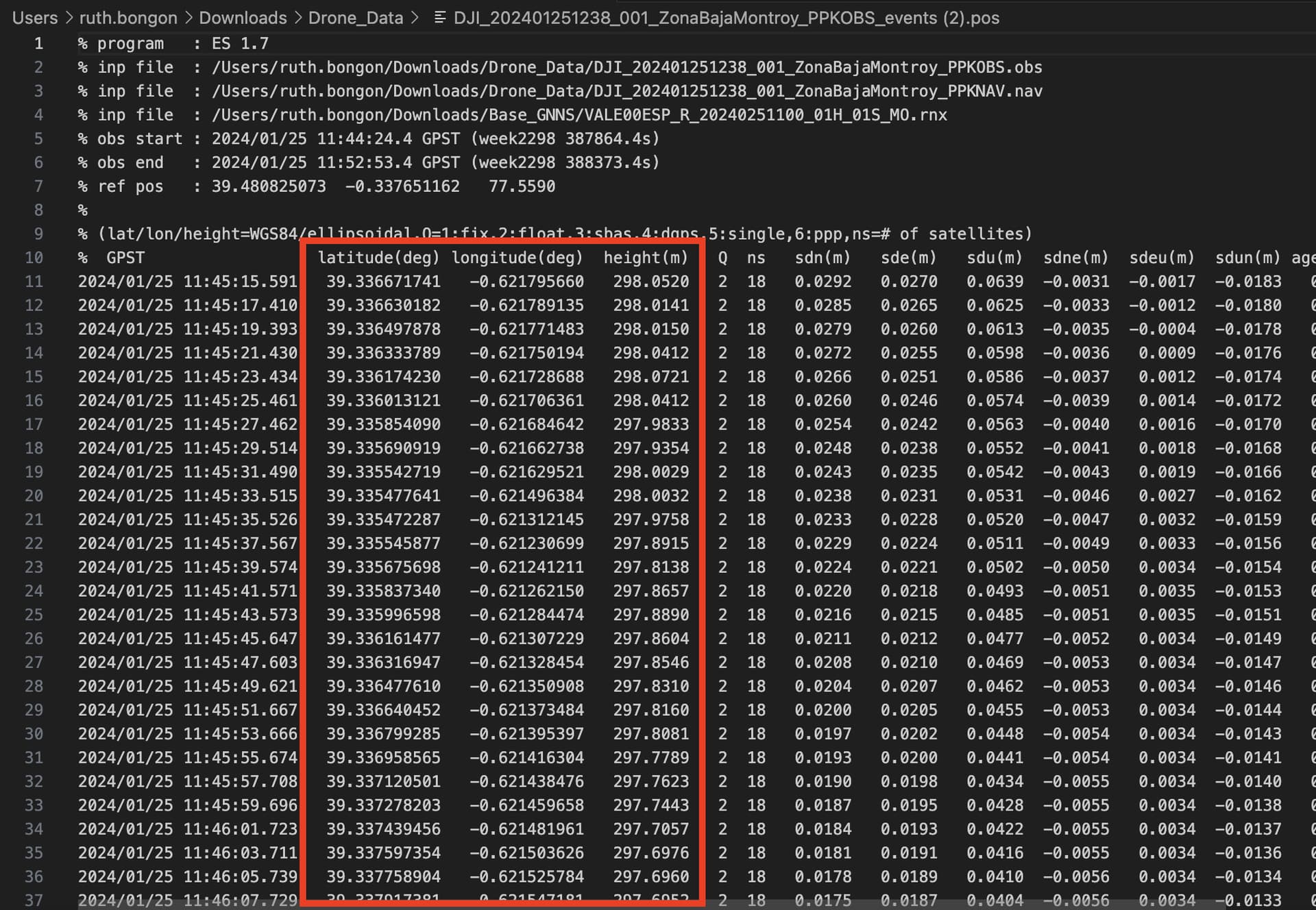
Did you ever end up using the raw _events.pos or .pos file in Metashape? If so, how well did it work? From what I can tell, the _events.pos file contains fewer entries than I have photos, while the .pos file has more entries than the number of photos taken.
The .pos file contains the trajectory of the drone. On the other hand, the _events.pos file contains a list of accurate coordinates corresponding to each photo a camera makes.
You can copy the latitude, longitude, and height from the events.pos file, create a .txt or a .csv file, and format it according to Metashape’s specifications.
This does help. Replacing the geolocation from the raw TIF files with the information from the events.pos file would work, and this is a normal part of our regular Metashape workflow.
After some additional tests, I noticed during testing is that the Emlid Reach M2 will accurately record the location of each photo if they’re captured as JPG files by the camera, but if the photos are originally captured as TIF files by the camera then the number of events does not match up. This is likely the reason the number of events in the events.pos file was not matching up with the number of TIF photos I had captured. After changing the camera to save images as JPG files, the number of events matches perfectly.
Do you have any idea as to why this may be the case?
You can add me as another +1 for adding positional metadata to the TIF files.
Why would it be useful for me? In my case I’ll sometimes be recording aerial photography using .DNG files in preference to Jpegs. Those DNG files will be processed out to .tif files (correcting for white balance, contrast & exposure). In turn, those Tif files will then be used as the source for Metashape to create a model. The .Tif files will then be passed to the UK National Archives for historical records - unfortunately they don’t accept 3D models, so it would be useful to have the Geodata embedded within the .tif file - that way it stays with the file forever - an accompanying text file with coordinates would probably become separated from the images & be lost.
I could just convert the jpeg files to .tifs, but there would be a loss of image data in doing so as the image has already undergone compression into a Jpeg. By going directly from DNG to Tif, a high quality image can be generated without undergoing compression/recompression.
Correct. I wasn’t sure if it was the hot shoe adapter or camera malfunctioning at first, but I did a couple of tests to check. The system is a Nikon D850 with hot shoe adapter to the Emlid Reach M2 and is triggered to collect photos every 1-2 seconds via an external intervalometer (connected to the camera via cable). When setting the camera up to collect TIF files the Reach M2 was only capturing less than 1/2 of the image locations in the events file. I then ran another test collect capturing the photos as JPG files and the Reach M2 captured 100% of the image locations in the events file. I re-tested the TIF setup multiple other times with similar results: less than 50% of the saved TIF images were represented in the events file.