Hi,
we’re planning to use two reach units for surveying, using postprocessing.
We would like estimate in the field if the recorded data will likely suffice for a fix. Assumption is that the base station has very good satellite view, so we only have to look at rover data. (There is no way to look at the base data, we have no link)
I’m now using the following metrics:
- average number of sats in view
- average number of sats with SNR > 45 or, 40 …
- average snr
But I can’t get a clear relationship with fix status, some observations with average more than 5 sats with snr > 45 stay float even when recording data for 2-3 min, while others with <5 sats above 45 snr get fix in 1 minute…
Any suggestions on other metrics to use?
DOP/HDOP? (Any tip how to get this from Rinex / RTKRCV status?)
longest time span with n sats > 45 snr …
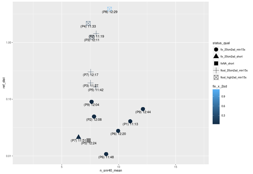
For example I tested the reaches against a reference (Topcon hiper L1/L2 using RTK from a external NTRIP caster).
I good fixes for most points, but especially when there is some obtrusion there is no or short fixes some time quite off:
This graph shows the relationship between mean number of sats. with SNR > 40 vs the distance (m, log scale) to the point measured with the Topcon.
1 Like
Hi Johannes,
This a very interesting topic.
I would suggest opening the .obs files with RTKPLOT, in options you will need to enable all systems used and “cycle slip” -> “LLI flag”. You will be able to observe DOP data there as well. Maybe that will help you to spot some correlation.
Yes, thanks. I will look into cycle slips and DOP.
We would like a scriptable solution, so we can have an app that pulls the raw data from the reach and then makes a fix probability prediction.
I don’t think RTKLIB can output this, I will look into other software…
Yes i would suggest DOP values! Obviously increasing the number of satellites in veiw increases the probability of having a lower DOP value (good). Obstructions decrease your field of veiw and therefore result in worse satellite geometry and a higher DOP value (bad).
Thanks!
And do you know any command line way of getting DOPs?
Is it possible with RTKLIB cuis?
I installed the latest gpstk, in the documentation it says there is a CalcDOPS and DOPcalc tolls, but I can’t find them in the nlinux binaries (while most other tolls are there)…
DOP is available it rtkrcv status, we should include it in ReachView as well.
1 Like
That would indeed be a very useful feature!