


I made a typo when entering my base coordinates today, and so my survey is offset.
Any idea how fix in QGIS, or is there a better solution?
I have the correct base coordinates, and the wrong ones, so should be easy to calculate the offset (can that also be done i QGIS?).
yup. whats your final coordinate system?
Here is a screenshot from a different user having the same problem
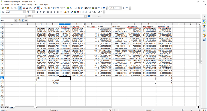
What i did was to:
1.import points to qgis
2.Change projection and apply shift variable
2 Likes
i did the same thing the other day
qgis , go to the toolbox, /vector geometry/translate
(there is also /vector geometry/project points/ )
since they seem to use distances i may have run the two points (the point you put in and the point you wanted to put in) through Inverse first…
Why don’t you post process? Are you having access to the base observations? I could run the files through my script if you like.
Would love to, but my base unit was collection static point data over night, and now won’t turn on, so can’t get to the base-log currently :S
ETRS89, which is what I have entered for the base coordinate.
Where is the toolbox?
I can find this: 27.1.18. Vector geometry — QGIS Documentation documentation
but not where it is found?
i assumed before that your data is already RTK corrected, if so then you just need to shift it, if not then you need to post process.
QGIS: View/panels/processing tools box/
then search for : translate
Did you have any success? If you provide the UBX files, the base position and the csv file of the survey I can post process the points for you.
Post-processing isn’t a problem for me, just wanted to learn how to correct in QGIS, but thanks for the kind offer!
In the View -> Panels, I don’t have a such item. I’m on QGIS 3.4.4. Is it a plugin or something like that?
Say several months after the fact I need to see what my base coordinate was, where do I find that? I see I have my RTCM3 message from base but do I need to convert it to another format so I can open in Notepad or similar?
Typical Scenario: I collect average coordinates for base with no correction input and save to survey and then operate in RTK. After fact I PPK my base coordinate. My RTK survey went great, all points had fixes. Just need to shift.
oh sorry yes it is a plugin, called “Processing”
i always have it loaded so i forgot its not a core thing
Got it! Needed to activate it first.
Sorry misread @tracy.love post  I’m on QGIS 3.2.1 and in all my other versions of QGIS have never had to load the processing toolbox, strange.
yeah i think that is what i need to learn to do when i can not ntrip it or opus it to begin with. but then all you can do is PPK with IGS product right? or do you go get data from CORS?
i have used http://apps.gdgps.net/
and i have used the Canadian PPP service https://webapp.geod.nrcan.gc.ca/geod/tools-outils/ppp.php?locale=en
but the accuracy wasnt fantastic even with a l1/l2
I just PPK my base against a CORS site. I’m playing with a project right now that I have to do just this on but am forgetting where to find or how to extract the original uncorrected base coordinate. It’s buried in a header somewhere…
OH, damn, well i hope you find it and i hope you tell me cause that sounds like a common situation i would find myself.
The link to the inverse calculator you gave above, only gives a direction and slope distance, but the Translate-tool need XY offset. Do you know other tools (online or in QGIS) that can provide this from 2 coordinates?