Creating the model 3D.
The position of the camera is unambiguous with the position Pixhawk autopilot to recording Yaw, Pitch, Roll angles.
Request to team Emlid about the introduction of option in the Emlid Studio of writing down the file with the data Yaw, Pitch, Roll angles on the basis Log Pixhawk - example „1980-01-06 00-59-42.bin”
Such creates the file geotagging Images with Mission Planner - example “location.txt” on the basis of the measurement RTK.
My request is creating the analogous file from Yaw, Pitch, Roll angles in Emlid Studio on the basis of calculations PPK.
One can to import the file with the data Yaw, Pitch, Roll angles to WebODM - Image Geolocation Files — OpenDroneMap 3.5.3 documentation
Do I understand correctly that you want Emlid Studio to generate files containing yaw, pitch, and roll angles, such as those in Pixhawk log data format? These files are similar to those used for geotagging images with Mission Planner and could be imported into WebODM for 3D modeling.
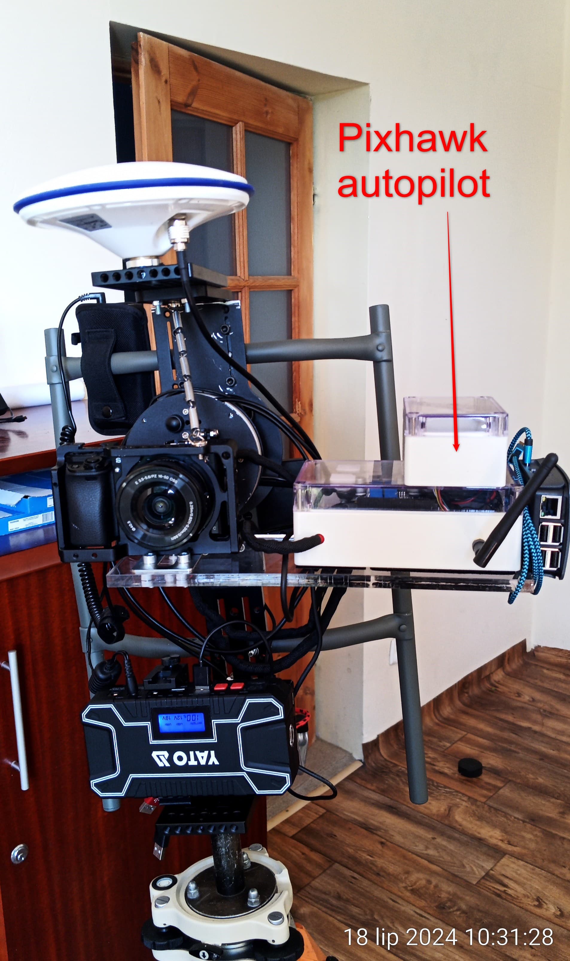
Could you share more about your setup? Do you use the M2 module or other Emlid products on the setup?
Do I understand correctly that you want Emlid Studio to generate files containing yaw, pitch, and roll angles, such as those in Pixhawk log data format? These files are similar to those used for geotagging images with Mission Planner and could be imported into WebODM for 3D modeling.
So, you understand well.
The Studio Emlid has to take given Yaw, Pitch, Roll angles from the file „Log Pixhawk” - „1980-01-06 00-59-42.bin”
The file “location.txt”. he is not standard for WebODM.
He is: #name latitude/Y longitude/X height/Z yaw pitch roll Salt
The correct order this: #name longitude/X latitude/Y height/Z yaw pitch roll Salt
If the introduction of the data Yaw, Pitch, Roll angles from the Log Pixhawk is impossible, then I ask only to generate: #name longitude/X latitude/Y height/Z in the file „file.txt” in the application Emlid Studio
I see, I suppose you want to get a file that is extracted from the .bin from Pixhawk log
to .txt with this format #name longitude/X latitude/Y height/Z yaw pitch roll Salt
If the introduction of the data Yaw, Pitch, Roll angles from the Log Pixhawk is impossible, then I ask only to generate: #name longitude/X latitude/Y height/Z in the file „file.txt” in the application Emlid Studio
Is the yaw. pitch, roll angles information recorded on the images?
We previously released support in Emlid Studio 1.8 to keep XMP tags from photo metadata that include yaw, pitch, and roll value. You can check about it in this thread.
I see, I suppose you want to get a file that is extracted from the .bin from Pixhawk log
to .txt with this format #name longitude/X latitude/Y height/Z yaw pitch roll Salt
You understand well. I will add only that the parameter „Salt” is superfluous.
Is the yaw. pitch, roll angles information recorded on the images?
Lack of the registration of these data on pictures. They are only in the Log Pixhawk.
We previously released support in Emlid Studio 1.8 to keep XMP tags from photo metadata that include yaw, pitch, and roll value. You can check about it in this thread .
The different solution necessary is.
„file.txt”needs. Such file will give me also different possibilities. „file.txt” the calculation of the transformation will make possible me - WGS84 (EPSG:4326), height/Z (height elipsoidalna) on EPSG:2177 : ETRF2000-PL / CS2000 / 18 [P]; height/Z (PL-EVTF2007-NH). This will make possible me works in WebODM in the suitable arrangement of the reference.
An Emlid M2 like board that takes into account yaw, pitch, roll, and vector with a dual antenna set up would be super useful for a number of applications.
"The complete OpenMMS solution provides many of the same features and achieves the same (or better) accuracy specifications as comparable commercial systems. The hardware combines a lidar sensor, global navigation satellite system sensors, an inertial sensor, cameras, and computers, to create a tightly-integrated digital mapping tool. The software is easy to use, fast, supports multiple OS, and, when possible, leverages multi-core (CPU) and graphics card (GPU) processing.
** Commercial GNSS-Inertial process software is required as part of the workflow.*"
A dual antenna setup from Emlid and support in Studio would eliminate that requirement.
OpenGrade or OpenGradeX:
Dual antennas help with excavator grade control and is dominated by “big name” players.
A good overview of GNSS and construction equipment can be found here:
If a separate, dual controller is too much bother, Emlid could come out with:
updates to Studio to take the data from two (2) M2 units to work out yaw, pitch, roll, and vector in post-processing.
a “bridge” to link two (2) M2 units and present one data “stream” to a controller running GradeControlX.
a better solution than those as I’m just a simpleton
Always interested to see what Emlid can come up with.
Thank you for sharing your setup idea! I’ll raise a feature request to our development team based on your suggestions. Currently we don’t have plans to release this feature at the moment, but I will update you if there is any news.