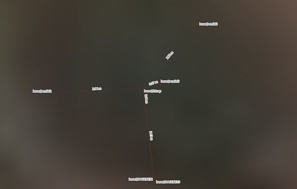
Hi! I established temporary bases to enable me to perform rtk using lora within 3 km from the survey mark. Occupied the the survey mark with rs2 with zero antenna height for ~4 hrs on 3 different instances as there were 3 temporary bases. On each instance an m2 is running on the temporary base . I processed the three instance of ~4 hrs using the cors network of the Philippine government (namria pagenet). I also processed the data using emlid studio. I am given different coordinates of the survey mark for each of the instance of ~4hrs raw data. In emlid studio, three different survey mark’s coordinates were generated as soon as the raw data was identified. I proceeded with emlid studio processing. As I have the coordinate of the survey mark (base@hinap), I opened up the resulting rover*.pos file, edit the “% ref pos :” and the “% GPST” lat, long and elevation to match survey mark. Fed the edited pos file to the manual base coordinates fields in emlid studio and re-run the processing. The newly generated rover temporary base coordinates was the one I used as manual base coordinates for rtk. Question, is the workflow I followed valid?
Hi @rogerix20002000,
Did I understand correctly that you can upload RINEX files to PAGENET for post-processing?
yes you can
I see. Then, I believe PAGENET uses network adjustment, which uses multiple permanent reference stations to calculate your position, while single-base processing (like in Emlid Studio) only uses one reference point. These different processing methods will naturally give you different coordinate results, even when using the same raw data.
But yes, your workflow is also valid. By the way, what datum are the coordinates of the survey mark?
its prs92 but i converted it to wgs84 which i believe is the default in emlid. Yes pagenet uses multiple reference stations which are static. the monument did not move on the 3 4 hour data collection instances and yet the coordinate of the monument given are different each time!! the 2nd and 3rd is only 0.105m apart which is great!!! but 1st and 2nd is 66.869m! and 1st to 3rd is 66.93m! apart. Thanks for confirming editing the rover*.pos generated during initial emlid studio processing and using the edited .pos file to reprocess and generate rover coordinate is valid.
Thanks for confirming editing the rover*.pos generated during initial emlid studio processing and using the edited .pos file to reprocess and generate rover coordinate is valid.
On the other hand, you can just manually enter the coordinates in Studio. There is no need to edit the .pos file.
the monument did not move on the 3 4 hour data collection instances and yet the coordinate of the monument given are different each time!! the 2nd and 3rd is only 0.105m apart which is great!!! but 1st and 2nd is 66.869m! and 1st to 3rd is 66.93m!
I’m sorry, I’m confused. Do you mean the results from PAGENET are different every time? Or is it the difference between the PAGENET and Emlid Studio results?
if you refer to the attached image of the post you will note the 3 different locations of the pagenet provided coordinates. Upon opening the rs2 rinex base raw data, emlid studio refuses to accommodate manual input of monument coordinates. So I have to let processing run, edit the resulting pos and that’s when the manual base coordinates becomes responsive to inputting the monument coordinates.
This topic was automatically closed 100 days after the last reply. New replies are no longer allowed.


