


Hi, I’m looking at using Studio to validate my GCP correction spreadsheet/workflow that I have used for some time. If Studio works out I will flip to it.
My situation is : 2x RS2, one logs as base, typically for 3hrs 4hrs max due to the small sites I visit. The other is used to establish GCP’s.
The base is rarely over a known point and I do not have a CORS account. (I will look into Emlid Caster soon) So I submit the Base obs to AUSpos.
AUSpos return a PDF of the ground mark. To my knowledge I cannot access a Obs file from the government agency for the observation period. Correct me if I am wrong, but to use Studio I also need an OBS file from the CORS ‘base’ - not just my RS2 field ‘base’.
Secondly, is there a demo of how to get GCP corrections using Studio if you have known coordinates? NB I typically work in GDA94 MGA55&56 AHD.
Thank you
PS the whole reason for this is a concern that I am double counting the APC of 0.134m
Hi Troy!
You can use the data from your rover and CORS or rover and base. With the first option, you make one step less.
We don’t have a guide about that, but the workflow is the following:
- First, you should process GCPs in Emlid Studio. You’ll get a corrected CSV file with geographic coordinates
- After that, create a new project with GDA94 MGA55&56 AHD in the ReachView 3 app
- Import corrected CSV into the created project. When points appear in the project, you can export them back. Now you have corrected GCPs in the desired CS
Don’t worry! Just specify the antenna type before PPK. Emlid Studio will take pole height values from the CSV file.
I only have the RS2 files and csv…no cors or outside connection correction. Therefore I am trying to PPP not PPK.
By 1st option do you mean in the Studio dropdown “Kinematic Processing” ?
What step is ‘less’ / missed?
In the step 'Stop Go with RV3 "?
Andrew would you mind looking at this diagram. Have I understood the fields correctly?
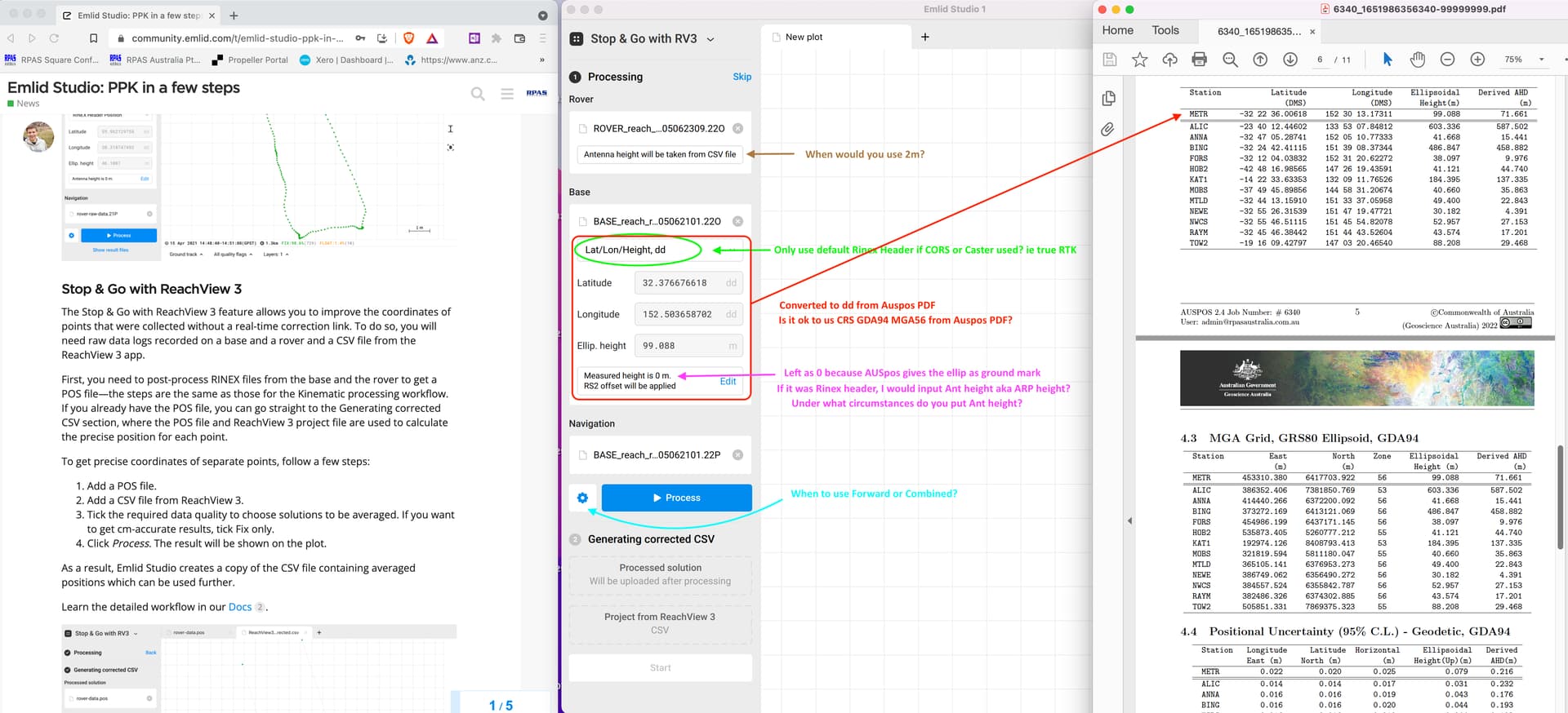
Things I have noticed/dont understand about Studio 1.
The green progress bar slides left to right counting up but then goes backwards…is that normal?
In settings; Filter…for GCP should I use default ‘Forward’ or ‘Combined’?
The documentation for Studio often says enter Base Ant Height but the diagrams are all 0…confusing, maybe have a blurred out number (as this will vary on tripod etc).
If the rover pole is set at 2m, that’s what goes in the field right or 0? confusing not knowing when the app is or isnt taking heights into account.
Thanks Andrew
Troy,
Oh, I got you now!
I mean that if you have CORS nearby that provides free RINEX data, you can use it with your rover’s data without establishing a base.
Yes, exactly.
Yes, you can use the coordinates from the PDF. Am I correct that these are permanent survey marks (PSM)?
Regarding the antenna height, you should enter it if the base has some lift above the PSM. The software calculates
The Progress bar goes backward if you choose the Combined or Backward filter. The forward filter actually replicates the RTK workflow. The Combined filter greatly helps to double-check solutions if the raw data is noisy.
In Stop & Go with RV3 window, when you select Rover’s data, it should show that it takes the antenna height from CSV. However, you should always specify the antenna height of the base.
This topic was automatically closed 100 days after the last reply. New replies are no longer allowed.