


When post processing with Emlid Studio I’m trying to understand why all records in the “Solution status” field are “Float” even though 5 out of the 8 records in my original csv file are “Fix”. What does this mean? Are the supposedly corrected points now downgraded to a “float” status after running them through Emlid Studio’s PPK, whereas they were classified as “fixed” in the original project? I was using Emlid NTRIP caster for my corrections when collecting data but it was impossible to get a “fix” signal under some of the more dense canopy areas. It makes me wonder if I should be using PPK at all when I have corrections being sent from my base to rover through either LoRa or NTRIP caster (where cell service is available).
Hi, are you comparing RTK and PPK data?
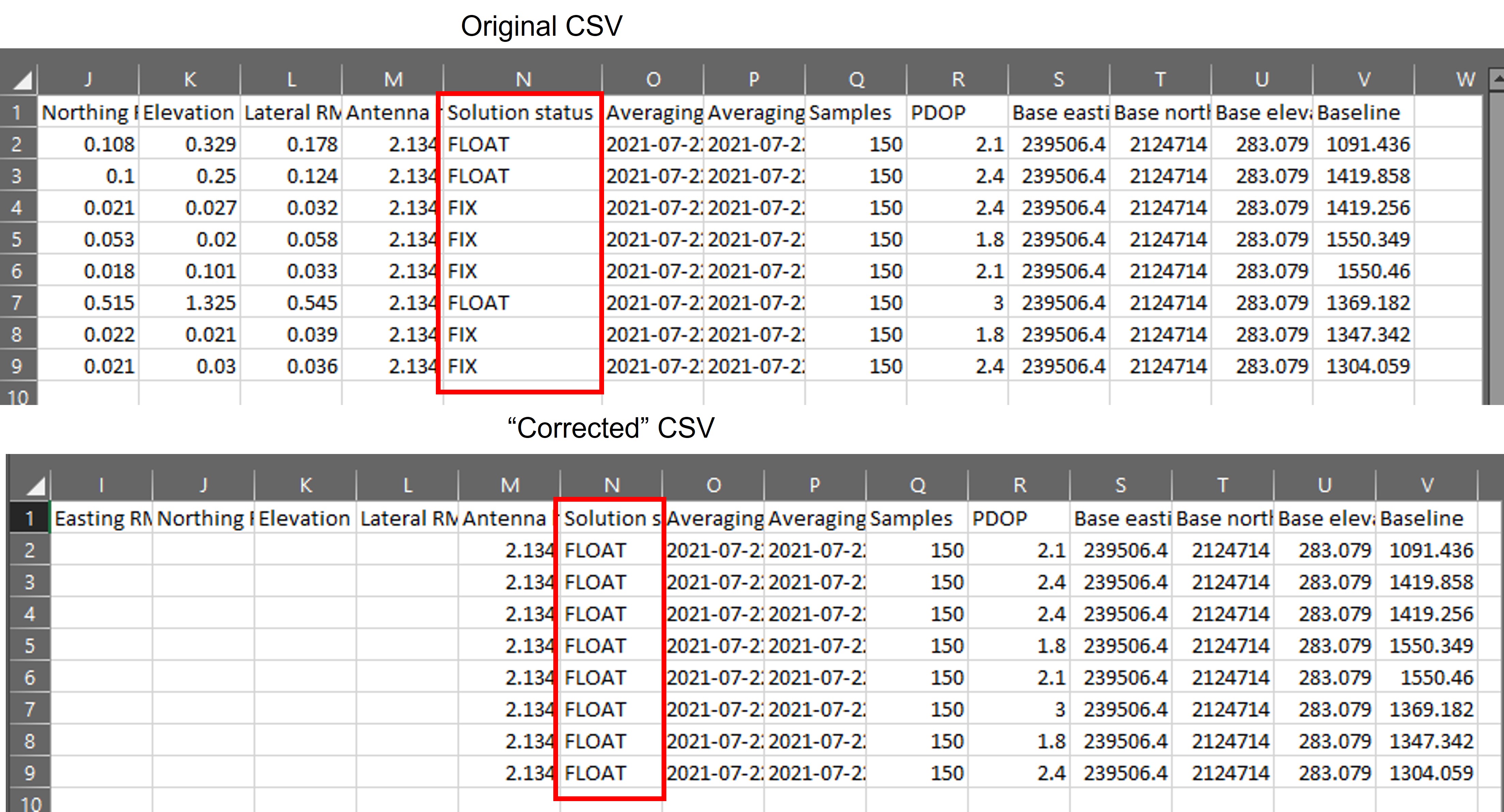
ref original vs corrected csv file.
Usually PPK is always a better and robust way to optain a FIX solution.
Can you provide the raw-data for reproduction? Base+Rover raw-files and the csv?
Here is a Dropbox link to the raw data, project .csv and .csv “corrected” with emlid studio.
I set my base station to average for 15 minutes and the project was set to NAD83(PA11) UTM Zone 5 North. You will notice in the original project file I also added a field for Geoid offset and Orthometric height. Not sure if I’m doing that correctly. There is no way to set it up with Emlid equipment because they don’t support Hawaii, so I have to edit the point elevations through the NOAA GEOID12B calculator. GEOID12B - GEOID - Data XXXXXTITLEXXXXXamp; Imagery - National Geodetic Survey
In the future it would be nice to be able to share this info with “Leaders” without having to make it accessible to the rest of the world, eh?
Thanks in advance for any feedback/advice!
Hi @sweet.scott,
Thank you for sharing the data! I’ll check it and come back to you as soon as possible.
It’s indeed possible to get a fix in RTK and only float in PPK with the same data. The result depends on PPK settings. So you can try to change SNR, elevation mask, or filter type, for instance, and check how it affects the results.
In the meantime, please note that we don’t recommend using our receivers under the dense canopy. Despite Reach RS2 is multi-band, it still needs to track satellites to get the solution in both RTK and PPK. That’s why forests are not suitable conditions for receivers. As an alternative, it’s possible to use a total station in this case.
1 Like
Hi @sweet.scott,
I’ve looked into your data.
RTK and PPK have different algorithms for calculating the solution. So it’s ok if results differ, especially if the data quality is poor.
As I see, the raw data logs from the rover have many cycle slips, and SNR is quite unstable. This is probably caused by the dense canopy in your working area. So it might be hard to get a fixed solution in PPK with logs of such quality, even if you have a fix in RTK.
There is no way to set it up with Emlid equipment because they don’t support Hawaii
Thanks for the report. We are already working on Hawaii coordinate system support.
In the future it would be nice to be able to share this info with “Leaders” without having to make it accessible to the rest of the world, eh?
You can always contact us at support@emlid.com to keep all sharing data private.
1 Like
Hi @sweet.scott,
We’ve already downloaded and processed the data. So I’ve deleted the link from your comment to keep it private.
Considering the differences, what would be the best result? The original CSV or the corrected CSV?
Hi Sergio,
It’s a good question. But the truth is I can’t say it for sure 
In general, the quality of the results depends on the satellite visibility: the number of satellites in view, their location (PDOP), obstacles presence. It’s essential for both RTK and PPK.
However, the RTK solution is also related to the stability of transmitting corrections while PPK is free of it. Besides, PPK allows playing with the settings. That means that PPK results are something mixed. For instance, you can try lowering the elevation and SNR masks or try another filter type. And it may change everything!
That’s why I can hardly recommend one of these methods as the best. They just are different, but both are precise and useful for various cases.
3 Likes
This topic was automatically closed 100 days after the last reply. New replies are no longer allowed.