I am using a one Emlid RS+ unit and connecting it via a NTRIP network in Southern California. I am using it to record GCP points to do Aerial mapping using a Phantom 4 Pro and post processing in Pix4d. I am finding my Z values are off. Using control points the smallest margin of on Pix4d is error z (m) 0.547074. I have a feeling I am not using an accurate vertical coordinate system. I read on another emlid forum that the Emlid RS+ records the WGS ellipsoid @ 0 height. I was wondering if GCPs can be acquired with the Emlid RS+ in either EGM96 or EGM2006 using only one Emlid RS+ unit connecting into a NTRIP network? Any advice or help would be greatly appreciated. I do not come from a surveying background so any insight is appreciated. Thanks again.
Thanks for passing this on. Do you know if we can change the vertical coordinate system selection on the Emlid RS+ to a geoid model such as the EGM96 or EGM2006 ?
If you dont mind, what QGIS tool or plug-in do you use? I have not been able to find any native vertical coordinate system or Geoid model support in QGIS to determine orthometric heights.
I think there was an old GNSS plug-in but not for QGIS3.
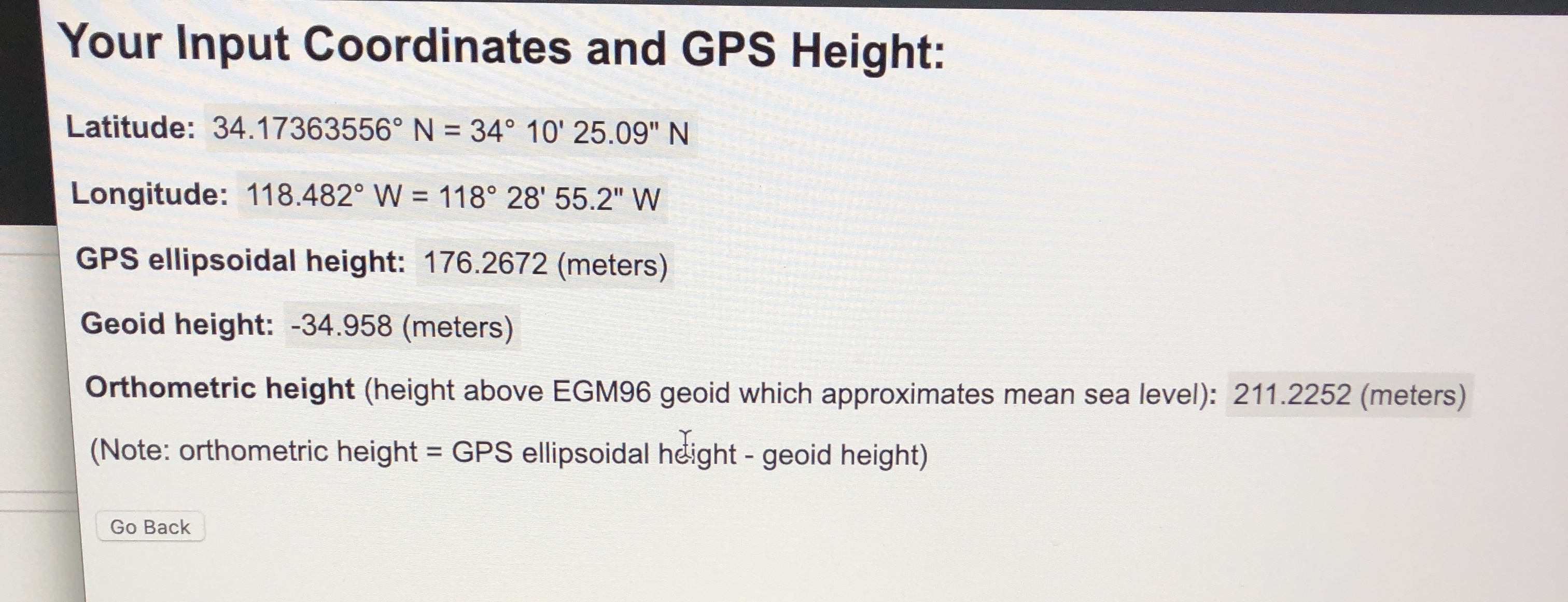
Thanks for passing this on, I have a couple of follow up questions. I inputted the coordinates for one of my GCP points into UNAVCO to convert them to EGM 96 and the results are on the attachment. Is the idea that I will re-input my elevation height for each GCP and Check Point into Pix4d using this new Orthometric Height? For example with the point on the attachment I will only adjust the elevation from the original GPS ellipsoidal height: 176.2672 (meters) to the new **Orthometric height, (height above EGM96 geoid which approximates mean sea level) 211.2252 (meters) and do this for each elevation point on map and then I can select the Geoid EGM 96 VCS on Pix4d? Thanks again for passing this on.
I had geoid difference as a raster layer and just used raster calculator. Not any specific plug-in. Try to find your geoid as a raster layer, or a grid.
I am a GNSS mapping guy, I have not had the time to get into the drone surveys (yet) or use the Pix4d.
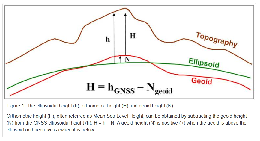
That being said, if you use your original GNSS ellipsoidal height in the control points as inputs, your products will be referenced to that. If you use the calculated orthometric heights, your product should be much more accurate representation of the landscape profile and the elevations should be closer to typical topo maps.
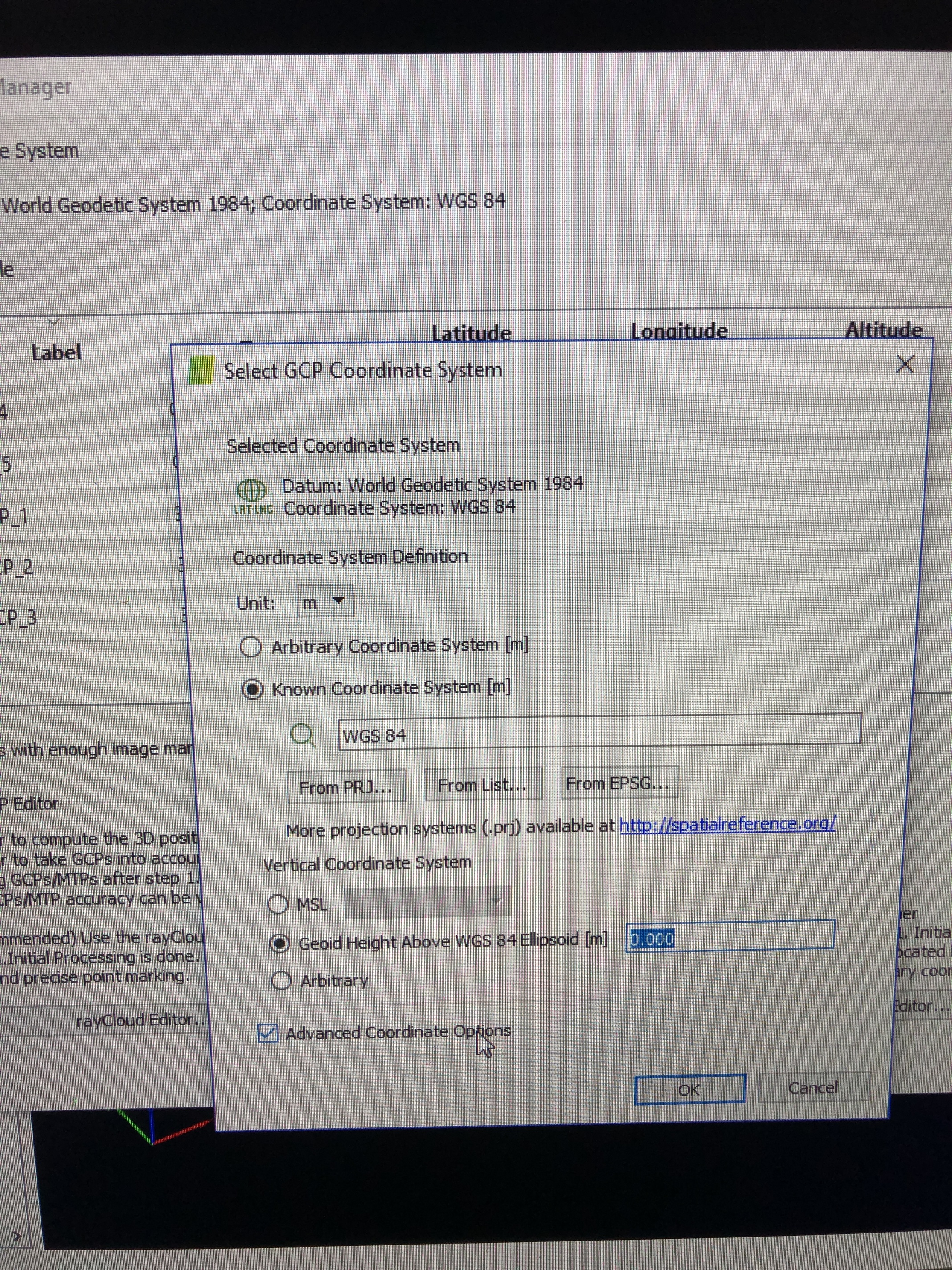
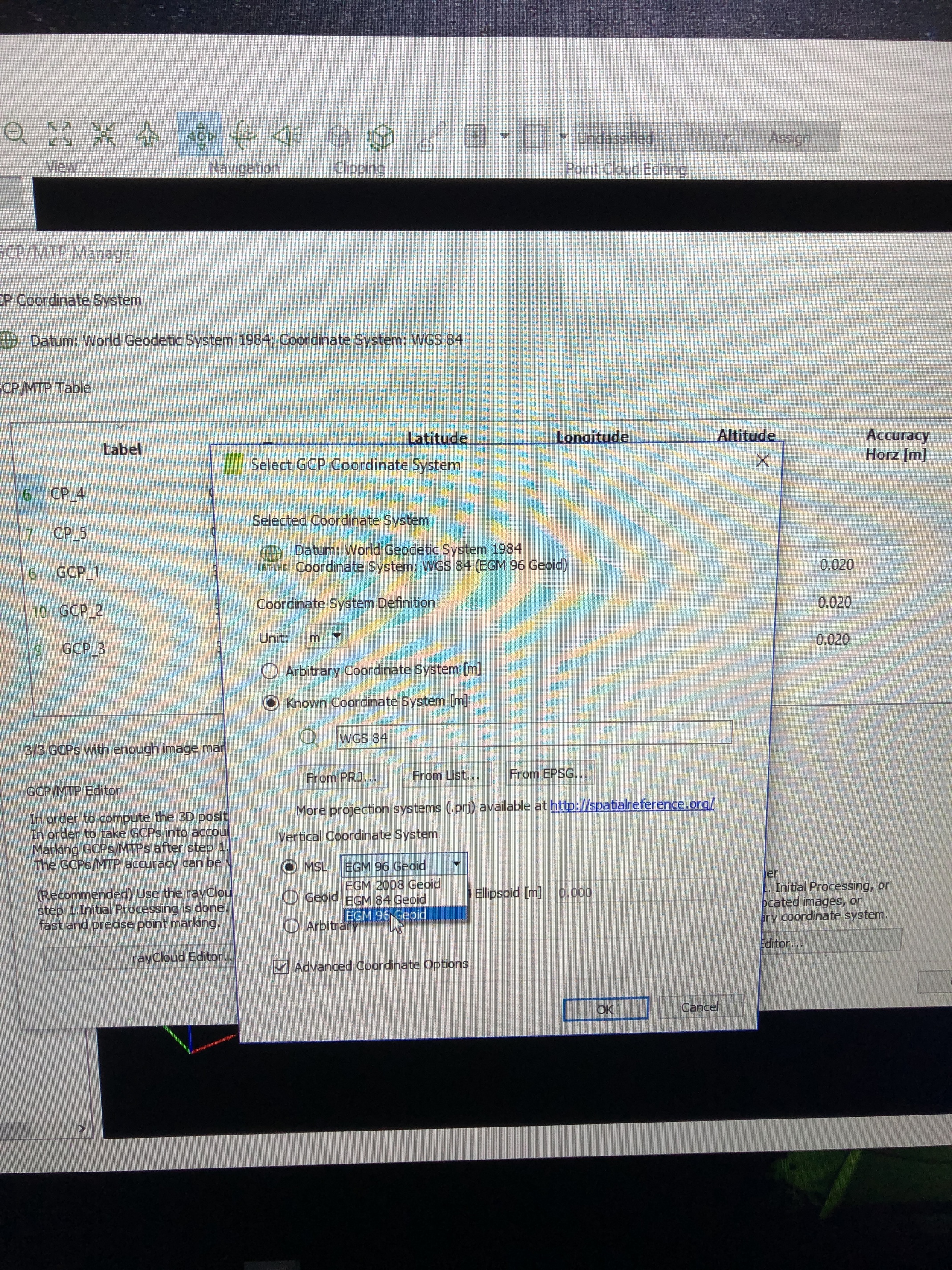
I am not exactly sure how Pix4d is utilizing the Z coordinate of your GCP’s. By selecting the GEOID EGM96 Vertical Coordinate System (VCS) is it trying to calculate an orthometric height? or is it asking you to choose which vertical coordinate system your points are in?.. Someone with more Pix4d experience here may be able to fill in there.
Or you can just do a quick test to see how it treats your new calculated coordinates and judge the results.
Thanks, from that list it looks like selecting MSL (Orthometric) and the geoid reference may be telling the software to calculate its own orthometric height on the fly?
Also keep in mind that the EGM 96 is a fairly course geoid grid that is suitable across the world, but it appears Pix4d does not support local (higher resolution) geoids.
What coordinate system is this NTRIP broadcasting? It may not be WGS84 or IRTF08 natively so you may be introducing an unexpected shift into your dataset…
Depends on your output coordinate system. Pix4D only supports a few internal geoid models EGM96 being one of them. It will take into account the geoid heights across the whole processing area (your last picture) and interpolate heights accordingly.
In your first picture you can apply a constant value to the height above the WGS84 ellipsoid (really any geoid model). This generalizes the geoid height across your whole processing area, however, and depending on site and location this generalization may not achieve the accuracy you need. I generally see much more variation in the geoid across my sites that a constant will do me no good.
I use Geoid12B to get NAVD88. Pix4D does not support the Geoid12B internally, yet. I convert to NAD83 and extract geoid values as @jurijs.jeshkins shows. I also use the UNAVCO tool but @jurijs.jeshkins way is fast. I do everything in QGIS. I then input my GCPs to Pix4D setting my vertical coordinate system to arbitrary.
Thank you very much for this detailed response @RTK_Hunter .
I just want to make sure I am following this workflow, so using the example I gave here is how I am understanding this new workflow
(1) I connected my Emlid RS+ to a NTRIP Station, specifically LAPC (station code within CRTN).
Site Name: LAPC_SCGN_CS1999
NAD83 Latitude: 34° 10’ 54.91411"
NAD83 Longitude: -118° 34’ 28.701993"
NAD83 Ellipsoid HT (m): 208.487
Geoid12B(m): -34.788
CA Orthometric HT (m): 243.275
NAD83 Velocity N (mm/yr): 29.01
NAD83 Velocity E (mm/yr): -25.22
NAD83 Velocity U (mm/yr): -0.61
GPS or GNSS: GPS
The coordinate system used is NAD83 so the corrections given to my Emlid RS+ are in NAD83
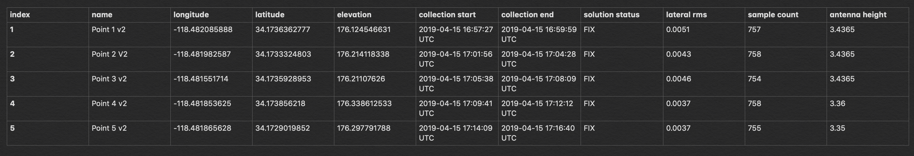
(2) From that my Emlid RS+ gave me the following points (NAD83);
See attachment.
(3) Since these points are in NAD83, I will then use UNAVCO to re-calculate my elevation heights from NAD 83 into EGM96. So I can manually input each elevation height to get Orthometric height instead of Ellipsoid heights? It seems like the QGIS way is faster but I still need to get up to speed with that workflow (my QGIS experience is very limited). Assuming I am using UNAVCO for the time being, will these new elevation heights then be corrected to now enter in Pix4d (assuming I select the EGM96 VCS)?
Thanks again for your message, really appreciate the help. It sounds like I need to read up on how to do this in QGIS to get a better workflow.