


I want to set up emlid with coords & an elevation previously obtained for the base point, so that I can capture PPK & broadcast a local NTRIP correction. There are 2 potential entries for antenna heights [tip of pole to base of emlid ant]: one in the manual settings and one at the bottom of the logging settings [attached captures]. For my scenario, should I enter the same ant height in both places? If not, which ant height should be entered: manual or logging settings? What would be the effect of entering the same height for both? Is the antenna phase center [134mm] height automatically included, by the reach app, for a height entered into the manual height settings?

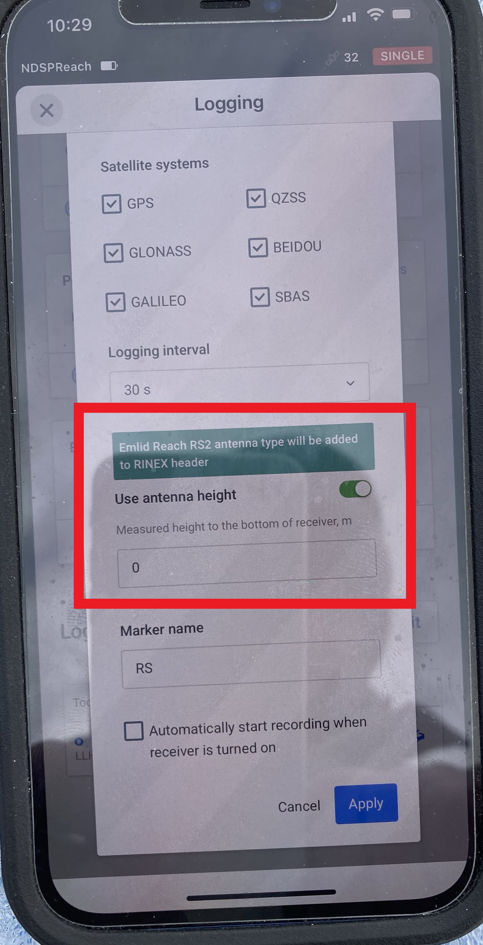
Clarification: my base mode settings capture, above, incorrectly, has the ellipsoid height boxed in red. I really mean: do I enter a height in the antenna height OFF/ON at the top of the capture?
1 Like
I’ve read thru the past forum posts, some more. I remain confused. I’d like for someone to comment on this screen capture, as it regards my original post question: on the base emlid what do I enter for each of the manual antenna hgt & logging setting ant hgt queries to properly do simulaneous PPK and RTK?
1 Like
Here is the way I understand it …
Under ‘Base Mode Settings’ this antenna height affects the correction you are sending to your rover from your base. If you antenna height is incorrect, then the rover will receive wrong RTK corrections and there is a good chance all your rover collected data will be wrong.
In the ‘Logging’ window this only affect the raw data being logged and the target height is just being written to the header in the rinex file, so that during post processing your program will read the target height from the rinex file and apply the appropriate corrections. Here it is not as critical, because if you enter the wrong value or forget to enter your antenna height your post processing software will normally give you the ability to enter the correct antenna height.
1 Like
snillor, yours is the only comment, about this situation, in over the 100 past posts that I read this weekend. Thank you for commenting. unfortunately, the results I get from capturing over two control points, seems to indicate that the base and logging antenna settings are, somehow, cumulative to the final emlid elevation.
In a rinex capture I submitted to opus: I think I had the HI [height to base of emlid] entered in both the logging and base. I also entered the HI in the opus antenna height query. The result emlid elev was = HI over the control elevation.
I did a single average capture with the HI entered for both base & logging and the result = double the HI, again, over the control elevation.
I did a survey project point capture, again with an HI entered for both base & logging settings. The result = the HI over the control elevation. After studying posts and emlid articles, I don’t understand when to enter an HI for each of these 3 capture methods.
I’m slightly confused, but are you also running two units? A Base and a rover?
A single emlid RS2+. I’m trying to provide my agency training on the various capture methods. I don’t understand why the emlid elevations would be higher than the control elevations; with all of those antenna heights entered, the emlid elevations should be under the control elev.
apparently, for the survey project and single average captures, the emlid is not subtracting the HI [4.35’] from those captures; that must be done post process: I’d like someone to confirm my theory. However, why would my single average capture be 8.7’ above the control point elevation, if emlid was not using the HIs in it’s internal calcs, for the either the survey project output CSV or the display elevation for the average single? I’d really like one of the ladies with emlid tech support, Svetlana or Anna, to explain how to set the HI for each method: logging-rinex, single average, and survey project measure.
Correct me if I’m wrong, but It sounds like you are trying to compare the OPUS elevations to elevation you got from the “Average SINGLE” coordinate entry in Base Settings.
Without getting too technical, “Average SINGLE” in base settings does not refer to “a singular (one) averaged position”, but referes to the way you position is being calculated. SINGLE is the lowest quality solution, FLOAT would be a step up in quality, and FIXED would be your centimeter level survey grade quality.
In the reachview3 app go to STATUS and there you can see your precision next to your coordinates.
In SINGLE mode your height could easily be out meters in elevation and the errors your are seeing have nothing to do with the your theory on compounding antenna heights.
Get a FIXED solution (you’ll need a NTRIP service if you only have one unit) and then compare your elevations to OPUS.
Best of luck.
1 Like
I completed some tests, with the emlid, on a tripod, capturing over a control elevation. specifying no antenna HI, within the reach app, for any of the following tests: average single, logging a rinex for opus, and measuring a point in a new survey project all resulted in elevations that were close to the control elevation, if I subtracted the HI after the emlid elevations were calcuated within reach.
When setting up the emlid, as a base, to log PPK data concurrent with an EVO UAV flight, do we specify a height in BOTH the logging settings and with the base coordinates & ellipsoid hgt in the base - configure screen. If not both, which one?
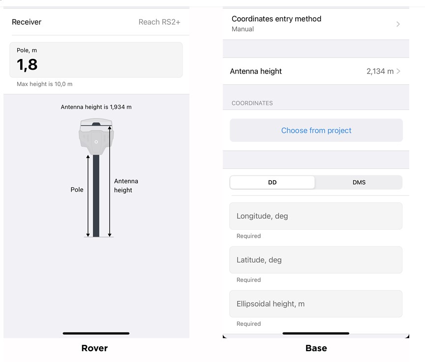
Im using the tripod adapter on the RS+ rover and wondering if it is better to add it to the pole’s height or is there a clear marker for the antenna height I can use?
Can you give me an idea of your workflow?
Is your base on a known point or are you establishing your base location? and if so what method are you using to establish your location?
Are you trying to tie your data down to some sort of established local datum?
1 Like
I’m trying to deter the advantages of accuracies of these methods, using a single emlid set up a known point, with accurate data: ave single, survey point, and rinex-opus. Svetlana explained that for PPK capture the ant height should be entered in the logging settings and that any ant hgt entered in the base manual page, to support an RTK capture, is not used in the ppk solution. The ant hgt for RTK capture should be entered in manual. The question I still have: what is the purpose of the height query within the survey tab - add point page.
The purpose of the height query in the survey tab is for when you are collecting data with a ‘rover’.
Example: You already have your base set up over a known, accurate, survey grade survey disk and have manually entered the x,y,z coordinates and antenna height in manual base mode settings. You configure the base to send out a RTK correction over a radio link. Now get your second unit, connect to the radio link transmitted from your base to get RTK quality corrections, open survey tab and here enter the rover’s antenna height, walk around the site and collect x,y,z coordinates for all your ground control points you are going to use in your drone flight.
1 Like
That makes perfect sense. I just completed a field test: emlid over a control point capture with single average. No antenna entry, so I subtracted the ant height from the ellipsoid elevation reported after the capture. Result: the emlid elevation is within 3’.
Yeah, I think I said it in a previous post here, but ‘Single Average’ solution is a approximate solution that could be out meters.
The single average can be useful if you plan on doing RTK and you do not have a known point to start off of. It allows you to do a quick approximate position, and collect RTK data with a rover based on the approximate base position. All your rover data is approximate too and relative to your base. Now lets say you also logged raw GPS data too and sent that to OPUS. You now a better quality base location that you have the ability to use to correct all of your ‘assumed’ rover data.
Best of Luck
3 Likes
Disclaimer: I do not have a RS+ rover (or any Emlid made antenna for that matter) and only going with what I’ve read an my under standing of how the Reachview3 App works with Emlid antennas.
If I understand the way RV3 works with Emlid antennas - you enter the distance between your Antenna’s ARP (Bottom of Mount for the RS+)and the point being measured in the pole’s height and RV3 knows the offset to the antenna height (Antenna Phase Center).
Example: You have a 2m rod with a 0.5m extension. Your ARP would be 2.5m above the point being measured. you would enter 2.5m as your Pole Height. RV3 will add 0.065m (I think that’s the offset for the RS+. The RS2 is 0.134m) and your Antenna height should then automatically change to 2.5m+0.065m = 2.565m, because that is the height of the antenna’s phase center above your measure point.
I use third party antennas with an Emlid Module and it does not know what type of antenna I have connected to it and cannot automatically adjust my pole height to antenna height relative to the physical location of my phase center for me. I have to manually input the measurement to the Phase Center instead of the ARP on my setups.
2 Likes
I’ve determined that, for emlid average single method captures, both the ARP & APC heights must be subtracted from the elevation figure, reported after the capture. to determine the actual ground elevation. We intend to use an average of 3 single method 2-min captures to establish a temp control point, with which to enter as manual method for an RTK broadcast to the Autel Evo UAV.
Your testing sparked my interest to do the same and I figured I’d share my results with you as well. All of my observations are on the same point, on the same pole, with the same antenna height of 6.75’. The below elevations are at ground level in feet and referenced to NAVD88.
Note: +/-0.10’ difference between OPUS and Smartnet is typical average difference between the two in my area.
OPUS:
10.758’ (6hrs)
10.755’ (17hrs)
10.735 (20hrs)
AVERAGE: 10.749’ (Standard Dev of Sample = 0.013’)
Nine 1hour sessions in Survey with FIXED RTK (SmartNet NTRIP):
10.847’
10.852’
10.815’
10.800’
10.881’
10.850’
10.856’
10.822’
10.855’
AVERAGE: 10.842’ (Standard Dev of Sample = 0.025’)
Five 2 minute Base Average FIX (SmartNet NTRIP)
10.771’
10.794’
10.873’
10.853’
10.883’
AVERAGE: 10.835’ (Standard Deviation of Sample = 0.05’)
Five 2 minute Base Average SINGLE
7.608’
6.608’
12.579’
15.686’
2.526’
AVERAGE: 9.001’ (Standard Deviation of Sample = 5.174’)
3 Likes