


The survey benchmark monuments that I am using publish elevations as NAVD88 (geoid 18) or Ortho-elevation. Is it correct that the RS2 units when set up on monument as a base require elevation to be the ellipsoidal elevation. If so does anyone know how to convert the Ortho-elevation (NAVD88) to the ellipsoid elevation (NAD83) or WGS84 ellipsoid? My work is in Utah, USA.
This is a pretty handy free tool for all your transformation needs ![]()
1 Like
The NGS Data Sheet (DS) that you probably already have, gives you the information you need. Using the partial DS shown below you would take the “*NAVD 88 ORTHO HEIGHT” (1668.001 m) and add the “GEOID HEIGHT” (-17.521 m) will give you a ellipsoid height of 1650.480 m.
The NGS Data Sheet
See file dsdata.pdf for more information about the datasheet.
PROGRAM = datasheet95, VERSION = 8.12.5.14
Starting Datasheet Retrieval…
1 National Geodetic Survey, Retrieval Date = OCTOBER 20, 2021
KN0260 ***********************************************************************
KN0260 DESIGNATION - G 43
KN0260 PID - KN0260
KN0260 STATE/COUNTY- UT/SANPETE
KN0260 COUNTRY - US
KN0260 USGS QUAD - EPHRAIM (2017)
KN0260
KN0260 CURRENT SURVEY CONTROL
KN0260 ______________________________________________________________________
KN0260 NAD 83(1986) POSITION- 39 17 54. (N) 111 37 20. (W) SCALED
KN0260* NAVD 88 ORTHO HEIGHT - 1668.001 (meters) 5472.43 (feet) ADJUSTED
KN0260 ______________________________________________________________________
KN0260 GEOID HEIGHT - -17.521 (meters) GEOID18
KN0260 DYNAMIC HEIGHT - 1666.285 (meters) 5466.80 (feet) COMP
KN0260 MODELED GRAVITY - 979,540.3 (mgal) NAVD 88
2 Likes
I found this tool and have been using it. I have changed NAD83(2011) State Plane, UT N Feet TO WGS84(G1674) to Lat Long for horizontal. For vertical I used NAVD88 (Geiod18) Feet us TO WGS84(G1674) to meters.
I think this will give me the correct coordinates for the base.
Thanks for the NOAA power point on geoids and ellipsoids. I do not have the NGS data sheet. I did find a tool by NOAA that I think will work. vdatum 4.3.
Thanks for your help.
Hi Mark,
In which coordinate system do you want to collect the points?
To set the base manually, you indeed need to enter geographic coordinates and ellipsoidal height. But these coordinates should be related to the same datum as your rover’s project. For instance, if you want to work in the NAD83 coordinate system with NAVD88 heights on the rover, you need to set your base in NAD83 coordinates.
As I see, the transformation tool by NOAA has already helped. But I can also suggest using GIS apps such a QGIS as an alternative.
I use QGIS and would appreciate your suggestions.
I could not find a NAD83 WGS84 datum in emlid reach 3. I found a WGS84 geographiques and used it, but not sure if it is the correct datum. The datums in emlid do not match those that I am use to working with (EPSG 4326, ITRF2008, WGS84(G1674, or NAD88(2011).
Is there a published list of all supported datums / ellipsoids?
Our orthomosaic software requires GCPs to be in WGS84 lat long or UTM. Is there a WGS84 that matches NAD83 in emlid? If so which datum is it?
Hi Mark,
As far as I know, WGS84 (G1674) was replaced with WGS84 (G1762). WGS84 (G1762) is available in ReachView 3. So if you need to get coordinates related to it, you can follow these steps:
- Transform your coordinates to WGS84 (G1762) using the NOAA transformation tool or QGIS
- Set the transformed coordinates for your base station
- Create a project on your rover in a coordinate system related to WGS84
At this step, you can set WGS84 (G1762) as a coordinate system for your rover’s project, and collected points will have geographic coordinates.
At the same time, you can also apply a UTM projection to the points. To do it, you just need to choose a corresponding projection in the list of available coordinate systems.
As a result, you’ll get points related to the WGS84 (G1762) datum in a UTM projection.
Just a note: you can walk through the same steps with WGS84 (original) or another datum. But you need to make sure that your base coordinates and rover’s project are related to the same datum and its realization.
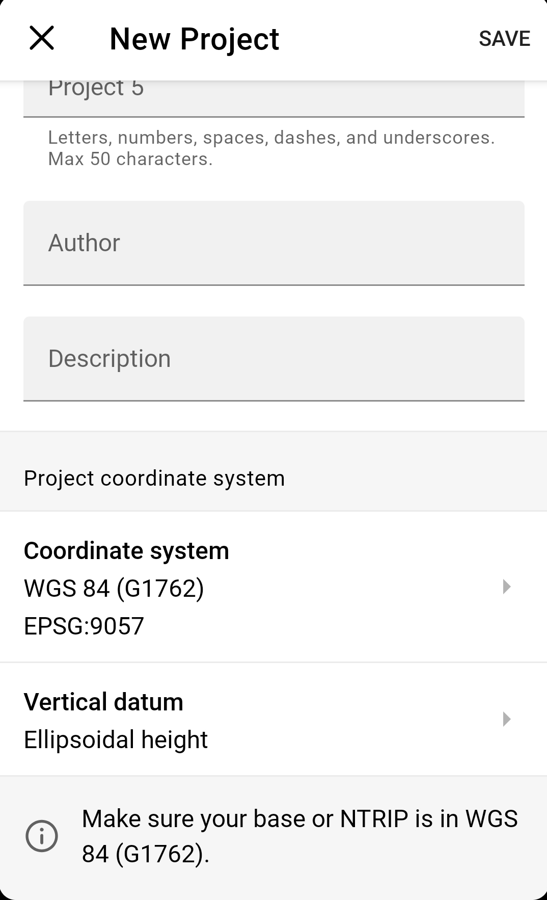
WGS84 and NAD83(2011) are different datums, but both of them are supported by ReachView 3. You can find them in the list of supported coordinate systems in the New Project tab.
At the moment, we don’t have such a list. However, ReachView 3 supports most coordinate systems from the EPSG database.
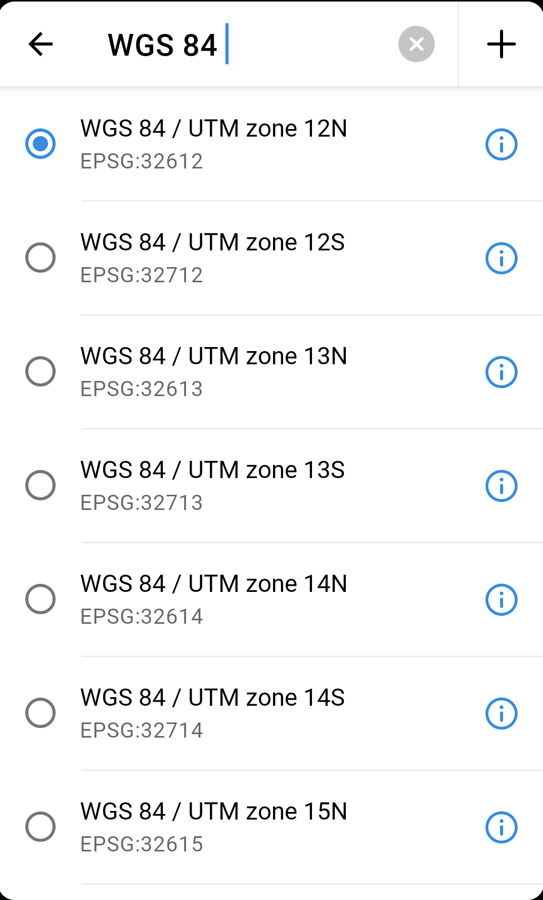
Your screen shot shows the WGS 84 / UTM zone 12N datum. This is the datum I need on the rover but I cannot find it going through the list in emlid Reach 3 app. Where do you get this from?
I did finally find the WGS84 UTM 12N (ESPG: 32612).
Using this on the Rover how should the Base be set up?
Our survey monuments use NAD83 Utah state plane (North, Central, or South) as the coordinate system and WGS84 datum with ortho feet (NAVD88 (Geoid18). The tie sheets also show latitude and longitude.
When I do not have monument the I use OPUS.
This is a great scenario for the base shift feature. At least now in the current firmware version
- You know the coordinates of the monument but can not feed it directly into the base without a transformation or you dont know how to
- You know the ortho elevation but not sure how and what to do with the ellipsoid
- You have the horizontal and vertical datum downloaded in the Reachview3 app
What you could do:
- Place you base near the monument (somewhere appropriate)
- Average base coordinates and configure your RTK with rover
- Open Survey in Reachview app and add your known monuments with know coordinates, both horizontal and vertical values and name it e.g Benchmark
- Move you rover over the monument and measure the point, save point and name it e.g shiftet point.
- Use the Base shift option and apply shift.
Voila, your rover is now referencing new points according to the datum you selected based on the known data you added and the monument.
2 Likes
Hi Mark,
Sorry for the delayed response.
Oh, it seems that I’ve confused you a bit. Now I see that you need to get NAVD88 heights and your survey monuments are in NAD83. So I believe that the easiest option for you is to use NAD83(2011) datum for the whole project. To do it, you need to set your base position in NAD83(2011) coordinates.
As for the rover’s project, you may set the coordinate system as NAD83(2011) as well or apply a projection such as NAD83 (2011) Utah (North, Central, or South) or NAD83 (2011) / UTM 12N. All of them are available in ReachView 3 app. NAVD88 heights can be set in the vertical datum field.
By the way, using a Base shift as an alternative to preliminary transformation to NAD83(2011) is a great idea. Thank you, @TB_RTK!
Thank you for this clarification. This makes it much more simple. Thank you.
I appreciate everyone’s help with this issue.
2 Likes
This topic was automatically closed 100 days after the last reply. New replies are no longer allowed.