We have a 800 image project with a M300 RTK. Emlid RS2+ Base station established with NTRIP FIX. We’re finding some large errors between our processing RTK data processing vs the checkpoints in Pix4D. Really scratching our heads to why but have noticed huge drift in the accuracy of the images.
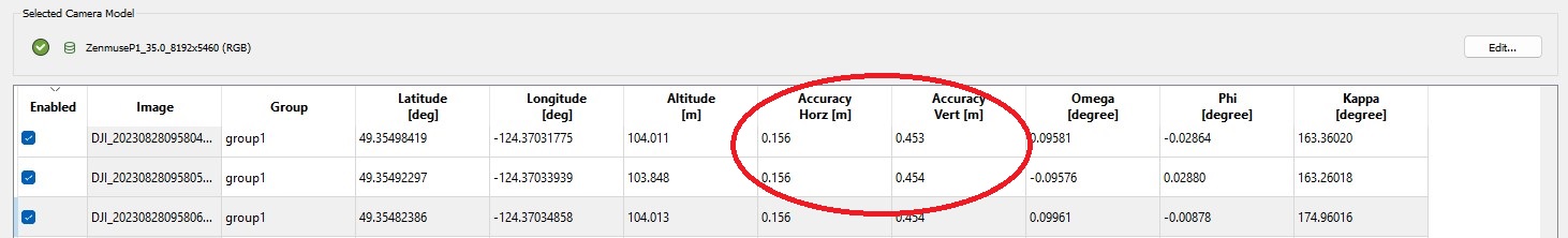
The first images have 0.038m Horizontal accuracy and 0.100m vertical accuracy.
The last images in the same mission drift by up to 0.156m horizontal accuracy, and 0.454m vertical.
Is that normal for the accuracy to change throughout a mission? Any idea to why that is happening? Is this why our outputs are so off, as verified via our check-points?
If I use the M2(or RS2 is the same) as local base station with my Mavic 3E RTK I usually have photo accuracy 1cm horizontal and 2cm vertical. If you have such big errors on the photo side my first thought is maybe the solution on the drone is not fixed and it is float? Maybe the RC had bad signal? Maybe the RC had limited internet access? Your other option is to try to PPK the mission. If you have logged the raw file on the RS2 is should be easy with emlid studio.
2-3 times I processed the PPK data and compared to the RTK solution and it was within 1-2 cm.
+1 to @vgo195 suggestion. For drone mapping, we usually recommend using PPK because it can overcome the inaccuracies caused by the update rate. Emlid Studio is a great tool for this. Here, you can find a guide about how to use its Drone data processing function.