


I am new to the Emlid Flow app and was wondering if the app provides the heading of movement away from a collected point and the distance traveled from that point. I am trying to lay out a smaller field inside the boundaries of a larger field and need to match the heading of the larger field boundary without having to walk back and forth and taking distance measurement from a mapped line and have to change the line points. For example: if larger field left side boundary has a heading of 359.8 degrees, and I need to place the starting point of my smaller field 200 ft away from the left edge I want to be able to map a point at the large field left boundary and walk perpendicular (89.8 degrees) for 200 hundred feet to map my start point. Is this possible?
Yes if there are lines on the bigger boundry then you just stake along that line
OK that makes sense but is there a way to determine the heading as I use that information to guide our equipment through the field?
Thanks David for the responses.
I have now figured out how to get to the step you have shown above.
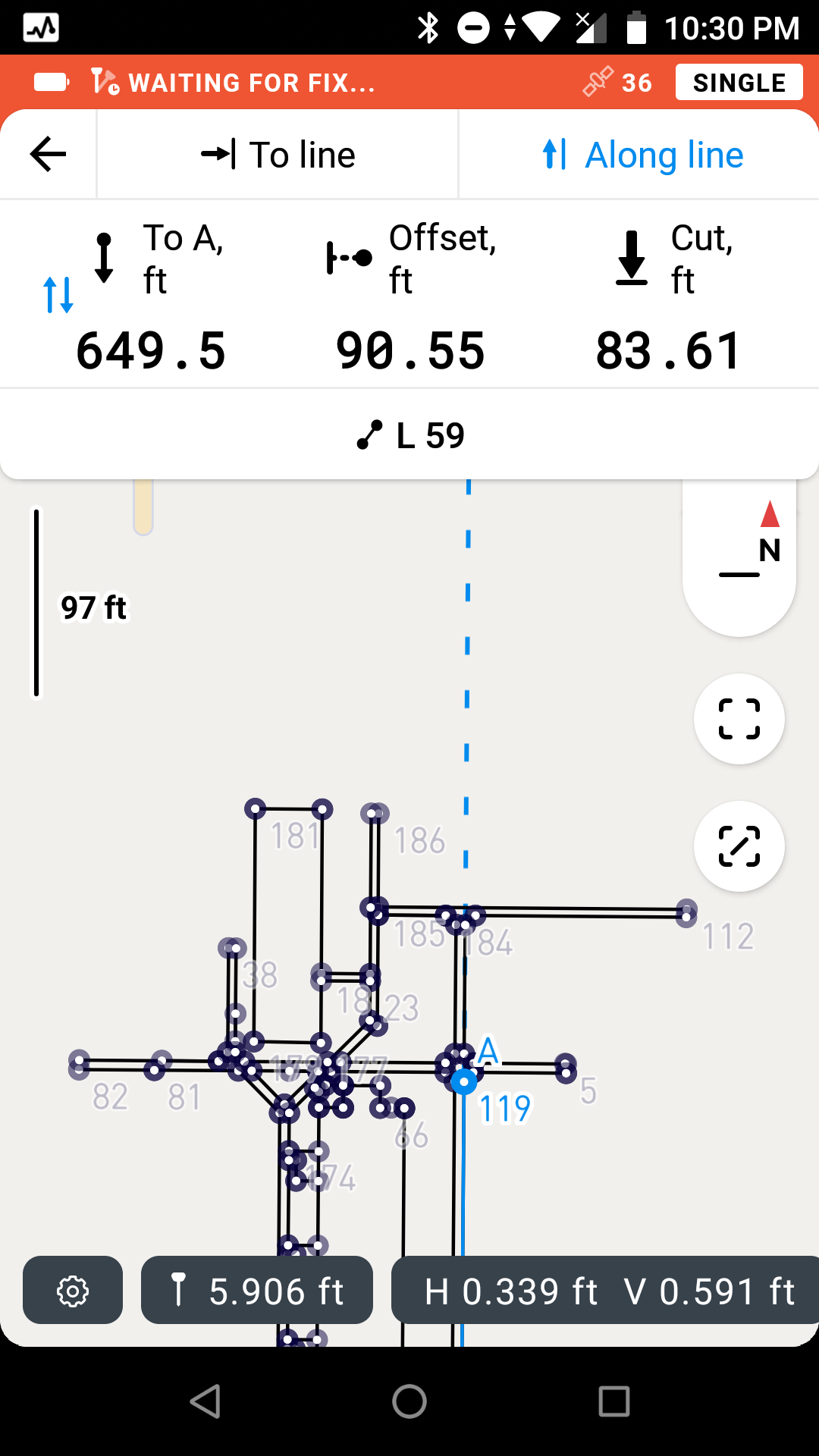
I know To A is distance from the A point, and Offset is distance from the line.
What is the CUT distance represent?
Also I noticed that toggles between Cut and Fill, what does Fill represent?
Thanks again for the help.
The cut and fill shows the elevation of the line or point , cut means lower your reciever and fill means lift the reciever
OK that makes sense, if surveying to install a level pad you would need to know whether to add fill or cut out dirt that is there.
So kind of back to my original question then, there is no Heading shown in the Flow app correct?
Are there plans to add that as a feature in the near future?
Also Showing the active distance walking away from the last collected point would be another helpful option when collecting points or lines.
Thanks
Hi Mike,
Welcome to the forum!
I just wanted to confirm what Dave mentioned. Currently, you can use the stake out feature as a workaround to calculate the distance.
We have azimuth calculation in the roadmap, and I’ll add your request as a plus one. I’ll let you know once we have any updates!
Regarding the feature where you can see the active distance from the last collected point, how exactly you would like to use it? Do you want to see distance for just one point or collect points at regular distances?
I’d like to see the “distance to last point” feature.
This would be an excellent way to verify the previous observation on a point and re-occupying for a second observation on the same point.
Javad has this feature and I use it all the time.
Bryan,
Thank you for the example. I would like to confirm: will you be using the feature to collect the point again and check the accuracy of the estimation? So, the point will have 2 measurements.
Yes, to verify the point and also collect the data for another observation (another point).
If the accuracy of both points are excellent, then perhaps an option to average or mean the group of points ?
It’s just a good confidence measure of the point you are collecting data.
Thanks
Bryan,
Understood. Added your request as +1 to our feature list.
My job is to map out a small rectangular area in a large field. I would like the capability to find the heading of one side of the field, usually a fence row, and use that heading to guide the layout of the smaller area so that it is parallel to the starting side. I would also like to see the distance that I walk away from the side that I obtained the heading from to determine where my start point will be for the smaller rectangular area. Once I find the start point then I want to see the heading and the distance that I am walking toward the next corner of my rectangle. This will allow me to determine the length of and heading of the line between start point and point 2. I need to see this on the point or line collection screen of the app, live in real time instead of having to create a line and then select properties to determine the line length and then have to add another point to the correct distance.
Thank you for the detailed description of your use case! Added your request to our COGO feature list. I’ll let you know once there are any updates.
This topic was automatically closed 100 days after the last reply. New replies are no longer allowed.
Bryan,
I want to update you. You can now collect stakeout points in the Emlid Flow 10.1.
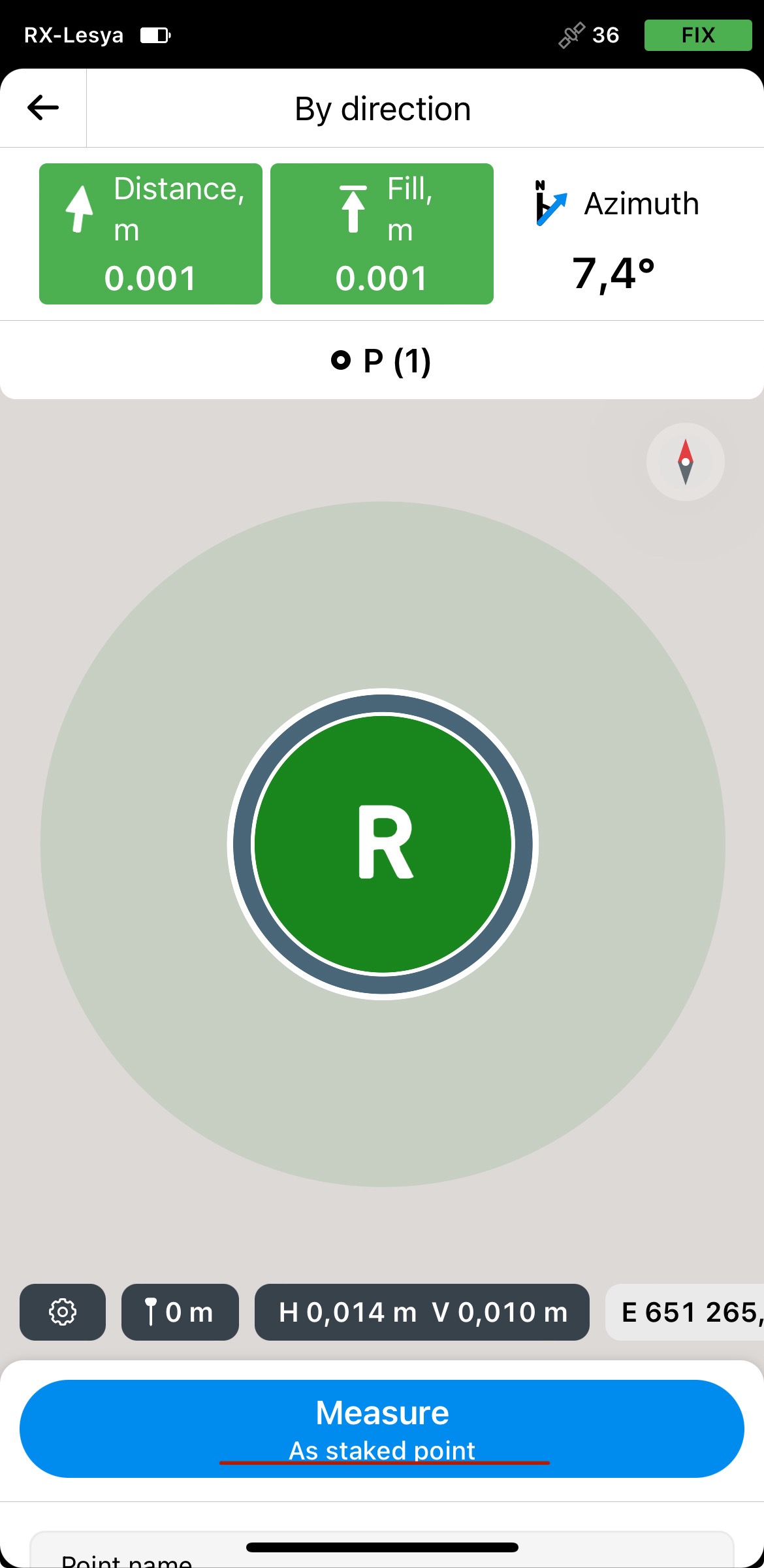
You can also generate a stakeout report:

It’s not possible to average the mean points, but your request have been passed.
The feature is available under the Survey plan. If you’d like to give it a try, you can get a free 30-day trial of the Survey plan. We’d love to hear your feedback!
Thank you
Mike,
Our traverse feature is out in the Emlid Flow application. You can read more about this feature here. The feature is part of the Survey plan, and if you’d like to test it out, you can get a free 30-day trial here. Let us know how it goes!