Hi!
I wonder how big of a difference it makes when the pole the emlid is mounted on is not completly straight while measuring. And why? Can a slight angle make big differences due to the distance of the satellites somehow?
Hi!
I wonder how big of a difference it makes when the pole the emlid is mounted on is not completly straight while measuring. And why? Can a slight angle make big differences due to the distance of the satellites somehow?
Not sure what you mean, if you dont have your pole vertical over your point its not going to be accurate.
If you think of reception signal to the above satellites, not so much unless you tilt it very much.
Could you elaborate?
It depends on what you are picking up and what accuracy you want.
If you happy for it it be a little out then it is fine. If you need it to be within 15mm then yes, it needs to be dead straight.
Ah ok thanks for the reply Ben! Does the 15 mm apply to both elevation and coordination accuracy?
The accuracy on both parameters are very important to me. But ive noticed that my collegues tend to be a bit hasty with the measuring and dont look at the doslibell while doing it. Ive tried to convince them its important that its dead straight but i can’t explain why and fail to convince them because of this
Back of the napkin math, If you have a 2 meter pole, and you are off plumb by 1 degree, your point on the ground will be off close to 4cm. 2 degrees, 8cm. (horizontally). A shorter pole and offsets will be less. Taller pole, offsets will be more. It’s fairly simple.
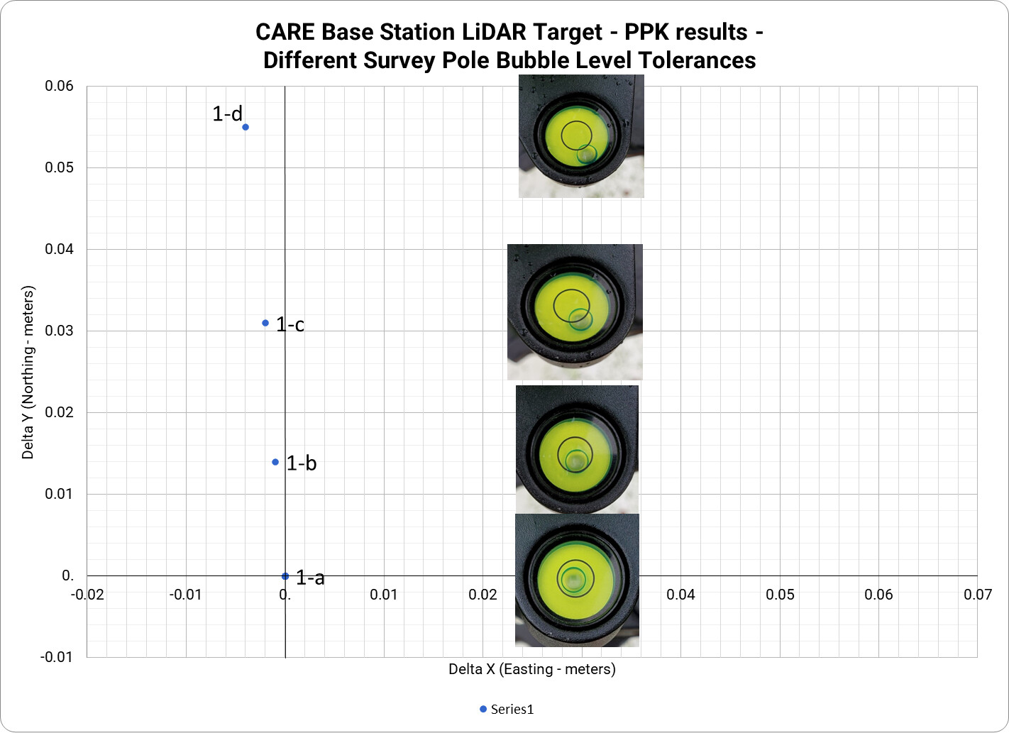
I am relatively new to this field, and decided to do some testing on my own to see how much potential error the pole angle can introduce. I took some photos of the bubble level, and plotted these on a graph showing how much error was introduced in each situation. A less than 2 cm error in horizontal positioning if the bubble was touching the edge of the circle seemed pretty small to me. As long as my team made an effort to keep it within the circle, I was happy.
If you have a 40’ (minute) bubble on a 2m pole and it is half off you calculate as follows:
(40’ : 60’) : 2 = 0,333 degrees
sin (0,333) = 0,00582
0,00582 x 2 = 0,01164
This is 1,164cm only through pole tilt.
You could use a 20’ bubble, but it’s tricky to handle for more than 5 seconds unless you
Regards
Buddy
Down through my many years of surveying (using both terrestrial traverse and GNSS positioning) I’ve heard so many accuracy claims, e.g. “our points are millimeter precision”, “we can provide sub-millimeter accuracy for GCP’s”, etc.
At best, using single point real-time RTN GNSS horizontal positioning with a rod/bipod setup that is perfectly calibrated you’re only capable 2-3cm using a state RTN. The vertical components can be at least twice what the horizontal error is.
Even using local (short baseline) real-time RTN GNSS horizontal positioning you’re approaching the same accuracy. At the local level, the base accuracy and rover accuracy has to be absolutely accurate. Many users don’t even consider that issue.
The only sure way of even trying to approach 1-2cm accuracy for both the horizontal and vertical components is closed loop post processing of all data using a commercial multi- baseline processor. This is assuming both base and rover rods are perfectly plumb. This also includes real-time RTK local aerial photogrammetry with post-processing.
That is true, Bryan.
Let’s see how mms become cms again:
The accuracy requirements of the trigonometric points of the highest order (DHDN) in Germany -expressed in 1-sigma (68.27%) standard deviation- are
Please note that this is only 68.27% confidence!
Multiply it by 2 to achieve 95.45% confidence and by 3 to achieve 99.73% confidence.
This means that an absolute (99.73%) coordinate, measured with GNSS post processed data only, can be as precise as
(The vertical component can of course be improved by the use of precision leveling, but we are talking ‘GNSS only’ here.)
Please be aware the RTK data providers can only guarantee you (1-sigma) 1 to 2 cm horizontal and 2 to 3 cm vertical accuracy.
2-sigma is 2 to 4 cm by 4 to 6 cm
3-sigma is 3 to 6 cm by 6 to 9 cm
This is why you always want to re-measure points and also check the current ionospheric index for your area to see what RTK signal quality (disturbances) to expect.
https://www.lgln.niedersachsen.de/download/121560/SAPOS-Broschuere_english_.pdf
https://www.lgln.niedersachsen.de/sapos/ionosphaerischer-index-i95-51389.html
(Update: The link above can be translated into English.)
Regards
Buddy
This topic was automatically closed 100 days after the last reply. New replies are no longer allowed.