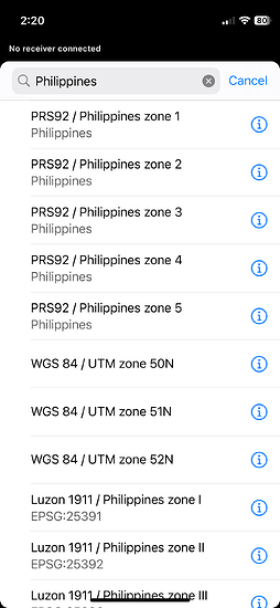
I have some issue to my previous project same project but different versions, the client issued TOPO with lot boundaries set to WGS84 zone 51 north (CAD file), and they issued also a lot boundaries with northing and easting coordinates in every corners but the coordinates is set to PRS92 zone 3 (PDF file).
I just only share how I deal with this, simply, I plot all northing easting PDF file issued, to my Cad file issued which is already set to WGS84 zone 51 north then I noticed that the movement of this 2 coordinates is perfectly horizontal. and the difference between the two coordinates is 215622.4074 meters.
I just want it to share if you are having trouble in transition between the 2 coordinates mentioned, if the cad file coordinates is WGS84 zone 51 north simply move the plotted coordinates from PRS92 zone 3 to this value “215622.4074 meters” going left side.
do the same distance value vice versa if your cad file is set to PRS92 and you want it also to move it from WGS84 the movement direction is heading right side.
Hi @criz5337,
Just wanted to note that the conversion from WGS84/ UTM Zone 51N to PRS92/PTM Zone 3 isn’t a simple linear shift. The collected points need to be translated into the X, Y, and Z axes, rotated in the X, Y, and Z axes, and reduced to a scale factor. So I recommend you convert the data using all the parameters to ensure maximum accuracy and consistency. You can learn more about datum transformation between WGS84 and PRS92 from NAMRIA’s website.
I can’t suggest a specific software or online tool that converts WGS84/UTM Zone 51N to PRS92/PTM Zone 3 and vice versa. However, I recommend joining this Facebook Group for Geodetic Engineers in the Philippines—Geodetic Engineers Group PH. I came across some posts in the group regarding recommendations for an application that does conversion between coordinate systems in the Philippines. You might want to check them out.
This topic was automatically closed 100 days after the last reply. New replies are no longer allowed.
Hi @criz5337,
I just wanted to update you that we’ve released the support for PRS92 with the datum conversion from WGS84. Now, you can use PTM projections based on the PRS92 datum.
Feel free to try it out!


