


Hi, you need the SK63 zone 2 and SK63 zone 3 coordinate system to work, or add to the entire territory Of Ukraine SK63 (1,2,3,4,5,6 zone)
Hi Vitalii,
As I know, SK63 transformation parameters are secret. That’s why they are not presented in open registries. If you have the parameters, you can use the New Coordinate System tool to work with SK63 in ReachView 3.
1 Like
Hi Ksenia,
- I found the required datum, they are in the program, thank you.
2. I need help: I have Emlid Reach RS + Reachview 3 program, I work in RTK mode, I use the UA-EUPOS / ZAKPOS network, datum EPSG: 5563, EPSG: 7827 I get the coordinates of points with an offset of 120 meters to the southwest relative to the control points, Tell me how to calibrate the control points or how to make settings to get the correct result, and then I’m tired of constantly recalculating.
3. It is not possible to select the datum EPSG: 5705, writes the wrong coordinate system.
Hi,
Is UA-EUPOS / ZAKPOS NTRIP provider? Do you know what coordinates system they use? I know that Ukrainian providers usually send CRS parameters in RTCM messages, which we don’t support at the moment. Probably, this is the issue.
And what do you use as a project coordinates system? EPSG:5563 requires USC-2000 for the base coordinates, while EPSG: 7827 requires Pulkovo 1942.
Can you share the screenshot?
1 Like
Hi Vitalii,
I get the coordinates of points with an offset of 120 meters to the southwest relative to the control points
Such offsets usually appear if something is wrong with the coordinate system setup. Have you checked Svetlana’s suggestions? If not, please ensure that the datum used by UA-EUPOS / ZAKPOS suits your project’s CRS.
Привет,
UA-EUPOS / ZAKPOS NTRIP провайдер, Как сказал мне координатор, система координат будет та какую я выберу у себя на контролере. Параметры CRS отправляют в сообщениях RTCM 3.1.
У меня только одна антенна, если бы я не поучал коррекцию от провайдера у мене не было бы фикс решения. Извините я пока только учусь работать в режиме RTK, много в чем приходится разбираться самому.
Кода выбираешь Балтийскую систему высот(EPSG: 5705) невозможно экспортировать точки , пишет не верная система координат!

Hi Vitalii,
Let’s keep our discussion in English. This way, everyone can understand it and feel free to participate.
As Svetlana noticed, Reach doesn’t support online transformations. I believe that’s the reason for the shift. For now, the only workaround is to use your own base station. However, we plan to support 1021-1023 RTCM3 messages required for online transformation in the future.
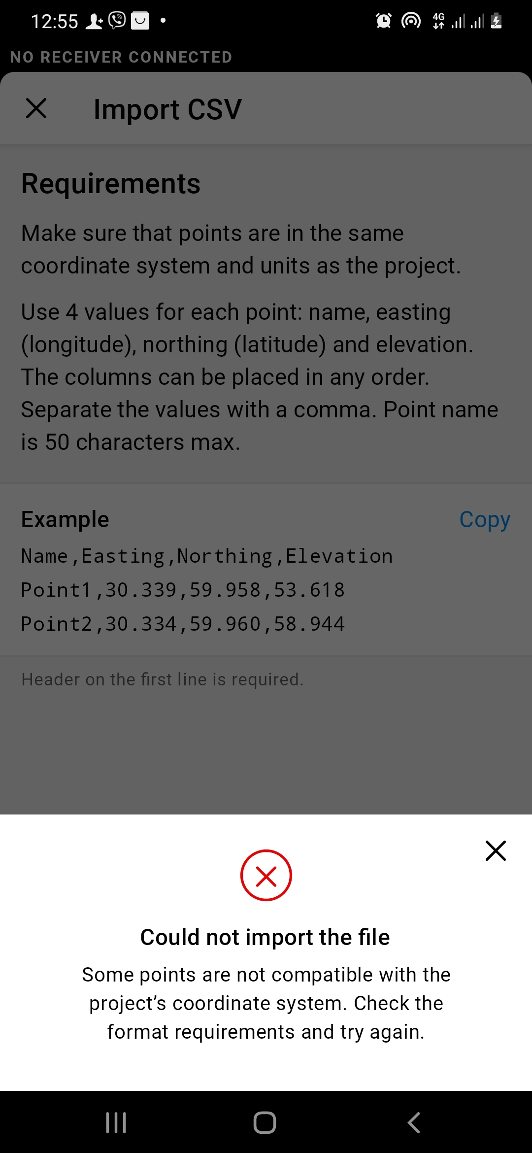
Talking about the CSV import, please ensure that:
-
The points are in the same coordinate system and vertical datum as the project (Pulkovo 1942 / CS63 zone X3 + Baltic 1977 height).
-
The CSV formatting is the same as in the example.
If it doesn’t work, please share the file with me. I’ll check what can be wrong.
Hi Vitalii,
Have you checked the CSV file CRS and formatting? Has it helped to import the file?
Good day
CSV format is normally loaded in any coordinate system when you select (Ellipsoidal height). I was not instructed to upload a DXF file, maybe I chose the wrong point format.
I do not have my own base station, it would be good if you speed up the work on supporting messages in the format RTCM3 1021-1023, My colleagues work with such a receiver with another program, I also think to move.
Hi Vitalii,
CSV format is normally loaded in any coordinate system when you select (Ellipsoidal height).
The points can be rejected if the CSV file CRS/vertical datum differs from the project’s CRS/vertical datum. So, it’s vital to ensure they match before uploading. Also, you need to follow the CSV format shown in the ReachView 3 app. If these suggestions don’t help, you can send the file to me for a closer look.
The 1021-1023 messages support is a complicated task. So, the implementation will take some time. Still, thanks for requesting it! It’s always good to know which features are the most anticipated.
1 Like
It will be great work to add this type messages.
Another app Nuwa have 4 parameters - https://youtu.be/JSmQKT5f3mQ?t=200
But this 4 parameters is local for SK63 in radius 30 kilometers from control point.
Parameters are not secret, but there are transformation field. Which is like small secret. I can generate it for you +/-0.02m quality. Transformation field it is like 1000 or 30000 points in 2 system of coordinates. Sk63 and USK2000. And this field use for transfer between systems. USK2000 rigidly connected with WGS84 by 7 parameters, but SK63 NOT.
Hi Nykodym,
It will be great work to add this type messages.
These RTCM3 messages are already in our roadmap, but I’ll note it as a +1 request if you don’t mind ![]()
Parameters are not secret, but there are transformation field. Which is like small secret.
Thanks for the valuable details! What I love about the forum is that you can always find a person who can share local specifics.
1 Like
Hello, I’m dropping the link to the list of datuns for Ukraine, maybe something will come in handy for you at work.,http://vingeo.com/update/rus/Datums.ini
1 Like
This topic was automatically closed 100 days after the last reply. New replies are no longer allowed.