Does anyone know of a Data Collector and or Android / Windows software that will combine Emild RS X,Y,Z’s and record Disto/Rangefinder X,Y,Z’s and combine all outputs in a single coordinates and elevations file.
Also is there anything on the market that would work with Emlid RS similar to Geomax PicPoint? GeoMax PicPoint - YouTube
Buy a used reflectorless total-station on ebay.
A setup like the in your link simply have too many variables, like pole tilt, offset of the rangefinder, stability during lasermetering etc.
I’m working alone on existing assets (powerline ground & structure clearances) in remote & rugged locations that have limited to no phone service, I only need relative not absolute accuracy so a total-station isn’t an option although I do have a Leica S910; but I’m more interested in what I originally asked than getting additional instruments.
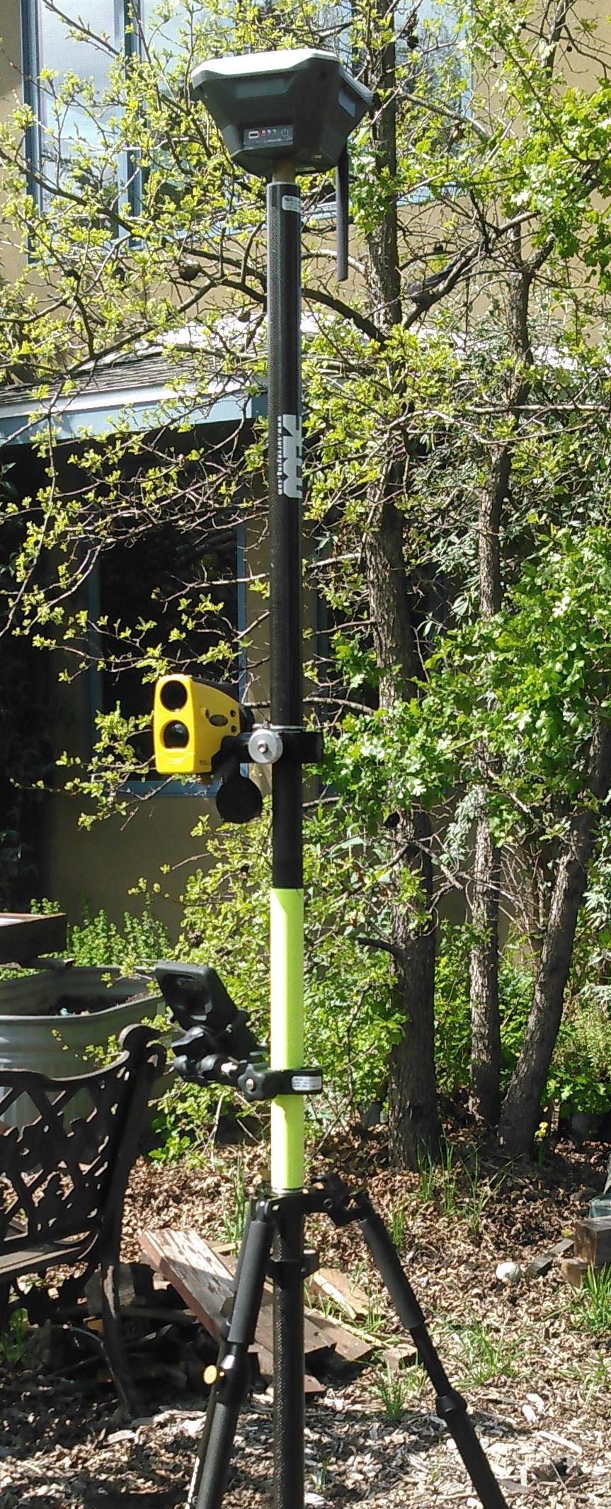
i have a trupulse 360B which i use with Mapit GIS on the android tablet (samsung active tab2, or LG v20 with big battery). i built a special 4 segment pole with a sleeve section so i can rotate and fire easily. sorry the photo i have of it really isnt that good, you would have to zoom in and try to make out the carbon fiber sleeve.
testing the trupulse 360b indicates its accuracy is as stated, 30cm or so to a high reflective target, but not bad for allot of work. i just use it for X,Y i havnt bothered to look at Z values as i figure they arnt so great and im useing it to map something like a post that is out in a marsh.
i also have a trupoint 300 which i think is the same as the lecia 910 and i have to say its not great and i have had no luck getting it to work with android apps like MapitGIS.
I’m trying to find a solution that is light & portable (not a total-station) to use on existing powerlines; mainly in remote locations with little to no phone service; I’m need to collect pole locations, pole attachment heights, mid-span conductor heights and structures under or in close proximity to thr wires.
Yes the TruPoint 300 is a re-branded Leica S910 but it’s loaded with LTI’s software a college also has one & fiends is to be difficult to work with.
the kind of mapping your talking about is not new and it is what the 360b is built for. you might find some good related info if you google " reflectorless laser forestry"
well based on what youve described, no cell service and detailed requirements, your going to have to use a base + rover RTK setup (RS2 set), or find the money for a PPP l-band setup, PLUS the laser. and even then you are just not going to get 10cm. youll get at best 20cm with the 360b and thats only if your laser is attached to a standard survey pole that is leveled and you have a FIX. even then often your wont have fix and then your gonna need to post process.
Thanks again @tracy.love.
I have two RS+ and have been using them in rover & base LoRa configuration with the Reachview App and was thinking of upgrading to RS2’s in the same configuration but including a data collector & introducing my LTI 360R & or Leica S910 to collect attachment heights, structures & points that have blocked sky-view e.g. conductors above roofs & awnings and roofs & awnings themselves.
I love my Emlids & their portability & simplicity to use but maybe I need to go with something like geomax with picpoint
More research I guess.
Thanks again