Hi Folks,
we have been asked to provide a final landform for our mine, which has just started production. Obviously, DEM from the drone will only give the current landform, so I pretty much have to design a form from scratch.
Does anyone have any recommendation of free software that would allow me to draw a contoured map with ease?
Thanks
Joe
Why don’t you hire a professional Land Surveyor ? We do approx 6 projects a month with clients requiring topographic surveys.
Most of our projects are in wooded areas, in which photogrammetry is useless. We have contracted out some projects using LIDAR but these were for large projects. We usually perform the surveys by terrestrial methods, most clients request 1’ contour intervals… this usually involves culvert inverts, sanitary sewer inverts, heights of utility poles/wires, location of structures with finish floor elevations, FEMA flood boundaries, flood elevation certificates, etc. Also, we usually provide an ASCII point file of all field points along with a DEM or DTM as well as the final map in an AutoCAD file for the design engineer or architect.
In our state, if doing business, you have to be a licensed surveyor or licensed in photogrammetry to perform such work. However if it’s an “in house” , i.e. engineering or construction firm, no licensing is required.
Creating a topographic map is an art as well as an involved process. Unless you are familiar with this type of work, you would be better off hiring a professional.
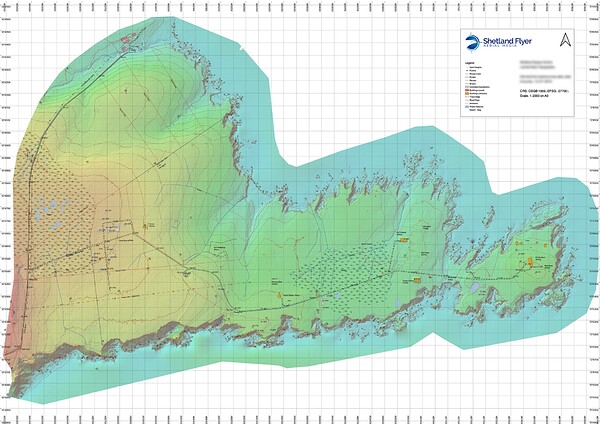
I would recommend QGIS for creating maps, it’s open source, has a huge plugin repository, and will ingest just about any data source. The attached 1:2,000 map was produced from aerial data in QGIS, the DEM was used to create the contours, and the ortho for the topographic data.
Creating contours without a DEM to extract them from will require manual plotting with line strings, you could use the original contour data as a base to work from, then edit the contour lines to match in with the final landform.
Happy to help out with QGIS, I have run several tutorials on using it with drone data to produce topo maps.
I’ve been meaning to start experimenting with QGIS, in fact a fellow professional friend uses it exclusively. Personally, I like Global Mapper and have been using since the first version. We also have the LIDAR module and use it with proprietary and state/county agency’s data.
It’s amazing when using the LIDAR data on sites that are mostly wooded while using terrestrial methods for topographic surveys. Comparison of both data is always done during reduction of the field data… accuracy of the LIDAR data is well within the vertical and horizontal specs as quoted. It’s always interesting to compare using known points such as road intersections, large rock outcrops etc. Approx 95% of the time the vertical/horizontal component of the LIDAR data is less than 5cm (0.16’). Even in wooded areas the vertical accuracy is usually less than 10cm (0.3’).
Pretty amazing I think !
I’ve dabbled a bit with QGIS over the years, and purchased Global Mapper at the end of last year. Surprisingly, QGIS is more refined and does a better job, and more easily, for some things. And, it is free. Maybe with more experience using GM perception might change.
One thing to note. I tried the SFM module in Global Mapper (Pixels to Points) on a trial about a year ago and found it very much lacking compared to Metashape when comparing a structure of known quantity. Global Mapper support were mostly indifferent when I brought it to their attention. I would consider the SFM engine in GM as more of a toy than Metashape or Pix4D. But other tools in the software are nice.
3d survey. It’s fantastic
This topic was automatically closed 100 days after the last reply. New replies are no longer allowed.


