I have some correction issues with my M+. Fore instance in the test I used some fix points in the field and I measure with the RS these coordinates and after I measure again the same coordinates on the field with M+. At post processing the M+ coordinates are shifted with 1.65m at vertical ax for all of points compared to RS coordinates (the RS coordinates has the reference coordinates from national cadaster system).
What is the problem with the M+? I have 2 antennas and I try to replace them with each other. Its reproducing the same issues both antennas.
Another example: I want to stakeout some coordinates determined by RS with M+ I have same shift issue at vertical ax (1.65m shift from North)
I tried to update the M+ software and the issue are persist.
It looks like the tripod or pole height was missed at some point. Did you use Reach RS as a base for Reach M+ in post-processing? How did you enter the base position in Emlid Studio?
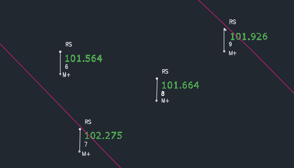
To the test (picture) I’m using both of them like a Rover, with same base correction system and same settings. After exported the DXF and CSV (to see the correction for every point exactly), for both of the GPS at each point has FIX-ed solution and good correction (0.010, 0.012), but the M+ coordinates compared to RS coordinates are Shifted (all of the points).
Another example:
When I’m using M+ to stakeout existing coordinates ex: D’ and D" points (base of the fance) the rover it’s indicate me the D’ and D" points with 1.65m shift from the exact location and coordinates of the fance.
When I’m using BASE+ROVER I using M+ to base and RS like rover I have same shift issue. (The M+ it was on tripod and the RS monopod). I set up the base with Emlid Flow > connecting both of the GPS to Flow > Hotspot and NTRIP setting (to the base receiver) > Base settings > and witch one is the base is calibrate on tripod and I start to measure average time 2 minutes in FIXED position. After is done I’m connect the rover with LoRa, when the correction is receiving from the base I start to work.
How can I solve my problem? Because is very frustrating every time when I start the GPS the correction it at another point. I’m not able to stakeout some points because every time the position X is shifted/drifted from exact location. How can I solve the problem? The GPS is FIXED solution but depend which base correction (NTRIP) are connect, the correction is fluctuating every time and my point is drifting from one point to another (the whole job).
I stakeout some point now and I mark it, when I start the GPS again (10 minutes 30 minutes 1 day later) the solution point position it will be shifted when I stakeout again! How can I trust in this solutions? How can I solve the problem?
I try to measure and stakeout in WGS89, but is the same problem! Point shift/drift every time when I power again the GPS, in some situation this fluctuation is happen when I’m working in the job.
Since the shift is the same each time, I’m pretty sure it’s just a question of the correct settings. We’ll sort it out, but I need to understand your step-by-step workflow.
To the test (picture) I’m using both of them like a Rover, with same base correction system and same settings.
What did you use as a base corrections system in these tests?
How did you place Reach M+ over a survey pole? Have you entered the pole height in the Survey project? Have you changed it before taking measurements with Reach M+?
I set up the base with Emlid Flow > connecting both of the GPS to Flow > Hotspot and NTRIP setting (to the base receiver) > Base settings > and witch one is the base is calibrate on tripod and I start to measure average time 2 minutes in FIXED position.
What NTRIP provider do you work with? Do you know at which system it transmits corrections?
Update: The correction issues are appeared in both of instruments when I compared again to another GPSs. Every time I start to measure (with both of instruments like rover), I complete the instrument Height to the correct value. The measured point shifting because bad base correction problem!
In generally I’m using STERE70 Pulkovo 1942 + Romanian MN75 height (when I create the job). And the correction base is received on WGS89 (but!) if I’m wrong with my setup I will be receive every time shifted or bad correction, not sometime good correction and sometime shifted correction.
And when I create to verify if I have WGS job and WGS correction the problem are persist and the issue are remaining my problem. Sometime is shifted sometime it’s okey.
My set-up for M+: 1.5m pole + 0.05 converter to screw the antenna on top of the pole.
And same set-up for RS.
If you are need some test jobs or measurements logs or something else, I’m able to send you what you want to verify and solve this issue.
I’ve just checked that Pulkovo1942 / Stereo70 requires base corrections in ETRS89.
I understand your point. But projections work the way that sometimes you can receive coordinates close to the correct ones and sometimes not. Because different datums (WGS84 and ETRS89) can be close to each other in some places and not close in others.
So, you definitely need your base in ETRS89 to obtain the correct results.
I’d suggest the following:
Connect Reach RS to the NTRIP and collect a point. You’ll receive the coordinates in WGS84 because your NTRIP sends corrections in this datum
Convert these coordinates to ETRS89, place Reach as a base, and enter the converted coordinates manually as a base position
Collect some points with another Reach and check if the results are good