Hello,
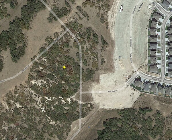
My background is in medical image processing and reconstruction, so I know very little about surveying or global coordinate systems. Please forgive the noob question. Near my property in Colorado, there is a survey marker with the following annotation: N: 1541873.24. E: 3185246.27, Elev: 6786.6
I’m not familiar with this, and was curious if it could be converted to an absolute latitude/longitude. An answer or a pointer to a reference would be greatly appreciated.
Hi Robert,
Do you know if the cords are meters or feet ?
You can use this, but find out what kind of units the cords are before using.
I’d say that has to be feet. Colorado’s not that big… ![]() I’m surprised they have 3 zones but everything I see is 1M,3M coords.
I’m surprised they have 3 zones but everything I see is 1M,3M coords.
@mdesignz What town is this closest to?
NORTH (FIPS 0501)
NAD83 Latitude N404908.05429
NAD83 Longitude W1044950.61174
SPCS83 Zone 0501 CO N
SPCS Northing 1541873.240 sf
SPCS Easting 3185246.270 sf
Convergence 0 25 56.79
Scale Factor 1.0000060
CENTRAL (FIPS 0502)
NAD83 Latitude N391909.66174
NAD83 Longitude W1045042.72957
SPCS83 Zone 0502 CO C
SPCS Northing 1541873.240 sf
SPCS Easting 3185246.270 sf
Convergence 0 24 46.71
Scale Factor 0.9999431
SOUTH (FIPS 0503)
NAD83 Latitude N380911.03629
NAD83 Longitude W1045120.79905
SPCS83 Zone 0503 CO S
SPCS Northing 1541873.240 sf
SPCS Easting 3185246.270 sf
Convergence 0 23 42.55
Scale Factor 0.9999608
Hello Bryan!
Thank you for the two references. I will check out both!
Hello MichaelL!
Thank you for the reply. This is in Castle Rock, CO.
By the way, the feedback on this forum is terrific. Thanks to all of you for your help!
Looks like Castle Rock is still in Central. I-70 on the north side of Denver is about the break to North zone. The coordinates I provided will be close but but may not be exactly the right ones as the converter I use is based on the FIPS system which a lot of Land Surveyors use but it is location dependent and just as likely that it could be NAD83 or NAD83(2011). The only way to know for sure is to find out what system that coordinate was stated from. Where did you get it?
@EBE111057 Can you enlighten on why online converters and a lot of Surveyors use FIPS? Maybe they don’t in your area…
TOOLS
The one I like is more visual. Download the KML.
Hi Michael!
There is a construction site in back of my property, and these coordinates were hand written on a couple of crossed wooden stakes. There was also a metal marker driven in the ground between them.
That’s interesting. I’ve never seen anyone write horizontal coordinates down for public viewing! If it’s construction then it is mostly likely localized and no longer any formal CRS. Only way to know for sure is connect to an RTN or setup a base on a certified reference point.
Close?
It’s because NGS database is based on the Federal Information Processing Series (FIPS), and Other Standardized Geographic Codes. This was established in part for the Federal Government database.
FIPS (Federal Information Processing Standards) are a set of standards that describe document processing, encryption algorithms and other information technology standards for use within non-military government agencies and by government contractors and vendors who work with the agencies.
We use the standard FIPS codes for the surrounding states as this is NGS’s procedure for their database. ex. SC 3900. This system is used for counties, states, NOAA Weather for each state, FEMA, the US census, etc.
It’s simply the government’s way to organize their data base.
Hi Michael!
The construction behind my property has just started, so there are no houses. While I appreciate everyone’s time, I don’t want to waste it since the marker was a curiosity. I was simply trying to relate its information to the Emlid receivers I have. Thanks again for your time!
-robert.
Thanks for the awesome explanation! I knew you were the right guy. In general how would you saw it compares to NAD83 and then that to NAD83(2011). I find all of them generally within 0.15-0.20ft H/ 0.20-0.30ft V but have seen areas where there was considerable difference which I attribute to more aggressive localizations and/or incorrect (not precise enough) scale factors. No coincidence that most of the places are 50+ miles from major town center.
There’s been several adjustments to “NAD83” down through the years, i.e. NAD83 (CORS96) Epoch 2002, NAD83 (2011) Epoch 2010. There’s not that much difference between them, however in some places such as Alaska and Louisiana area it could be a couple of feet horizontal and vertical; due to subsidence and plate movement. This doesn’t even consider California and a majority of the West Coast states that have large displacements due to crustal movement in their area.
They have several different NAD83 epochs based on different movement episodes through the years.
Hi Robert,
Just wanted to say that you can also create a survey project in Emlid Flow in the coordinate system of your benchmark and add your point to it manually using its local coordinates. After that, Emlid Flow will automatically calculate the geographic coordinates of this point.
This topic was automatically closed 100 days after the last reply. New replies are no longer allowed.


