


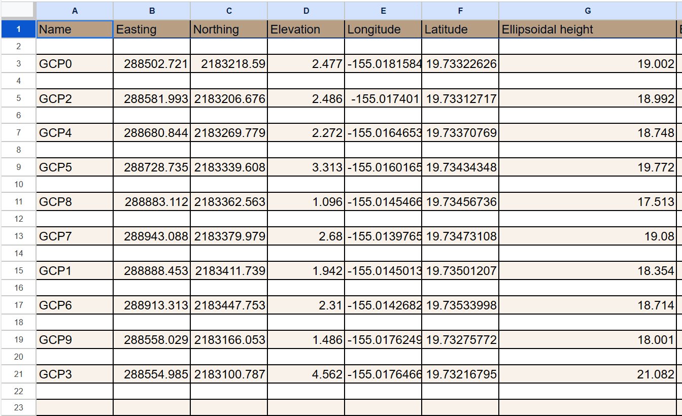
Hello, I am trying to figure out how to convert my elevation height values collected with RTK to LMSL using a local tide benchmark. My points were collected in NAD83/UTM zone 5N + NAVD88 (GEOID12B) height. I am confused if the values recorded in the “elevation” column are the adjusted orthometric heights using the GEOID12B model OR if I need to subtract the GEOID12B height value derived from our local tide benchmark (found here) from the “ellipsoidal height” column in the RTK .csv file to get the adjusted elevation value referenced to LMSL? For example, if the GEOID12B height of the local tidal benchmark is 17.52 meters and the Ellipsoidal height of one of our RTK points is 18.992 meters; would I subtract 18.992 - 17.52 = 1.472 m and that would my elevation referenced to LMSL? Or is there a different calculation that I need to do to get the LMSL adjustment? I am fairly new to this type of work so I really appreciate any help or advice. I also attached a screenshot of the .csv with the values I am working with.
Or another thing to think about… do I first calculate the orthometric height using the tidal benchmark datasheet which should be 20.409 - 17.52 = 2.889. And then find the differences using the LMSL Ortho Height found in the datasheet (2.36 m) by using the equation 2.889 - 2.36 = 0.529 and that would be my height adjustment? Lastly, I would subtract 0.529 from the “elevation” values listed in the screenshot above and would THAT then be my adjusted elevation value to LMSL? For example, using GCP2 (2.486 - 0.529 = 1.957) ?
Hi @megalabhilo,
Apologies for the radio silence here.
NOAA has an online vertical datum transformation tool that allows height conversion from one datum to another. As I see, you are located in Hawaii, and upon checking the transformation tool, you won’t have the option to convert the heights to LMSL.
In your case, the orthometric heights from Emlid Flow are computed from the Geoid12B model. It is a hybrid model combining leveled benchmark network + GPS marks.
As you have mentioned, computing the offset between the LMSL height and NAVD88 height and applying this offset to your measurements would be the best solution. I found this PDF from Caltrans (California Department of Transportation) explaining the process in detail.
This topic was automatically closed 100 days after the last reply. New replies are no longer allowed.