I want to set an RS2 receiver over a known point to serve as a base for RTK point captures.
The coordinates for my known location are in NAD 83 (horizontal) and NAVD 88 (vertical). The unit of measurement is US Feet.
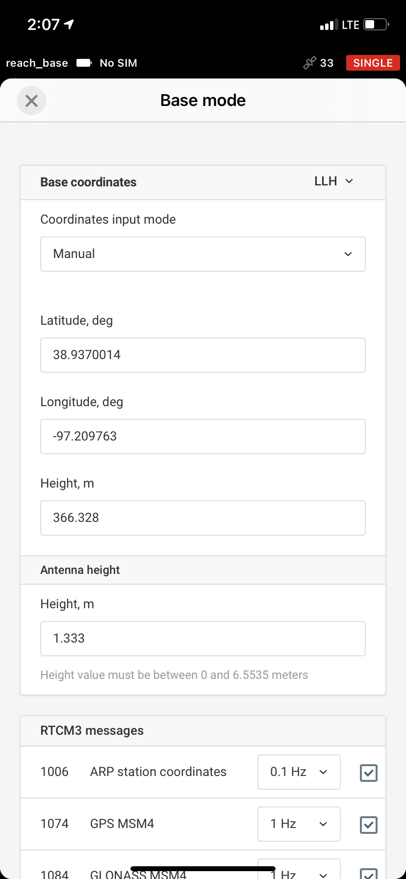
It is my understanding that I need to convert my horizontal coordinates to lat/long. I can do this using https://www.earthpoint.us/stateplane.aspx. I will then take these lat/long coordinates and put them into the fields for my base mode settings. (Using the LLH option, with lat/long in decimal degrees).
For the horizontal coordinates, should I use XYZ as my format instead of LLH. This way, I will just convert my coordinates from US Feet to meters.
Is one of these methods better than the other? Are there any flaws to these methods?
When creating my project, ReachView 3 says to “Make sure your base or NTRIP is in NAD83.” Do my above methods achieve this? I ask because there is no option in the base mode settings to select NAD83.
It’s all dependent on the datums your known point coordinates uses. If you want your resulting RTK points in NAD83 (whichever state plane you’re using as units in feet is definitely projected, not geographic) and NAVD88, you’re all set with your first option.
If you need them in a different coordinate system, then it will probably be safer/less hassle to transform base coordinates to the target system before doing the survey so you can set the project correctly.
Basically, your base coordinates as used to transmit corrections need to be in the same system you want your points to be measured in.
Bear in mind, you will not be able to enter the XY base coordinates in feet. You will need to convert them to their geographic form in decimal degrees first (the reference marker’s data sheet might have that already).
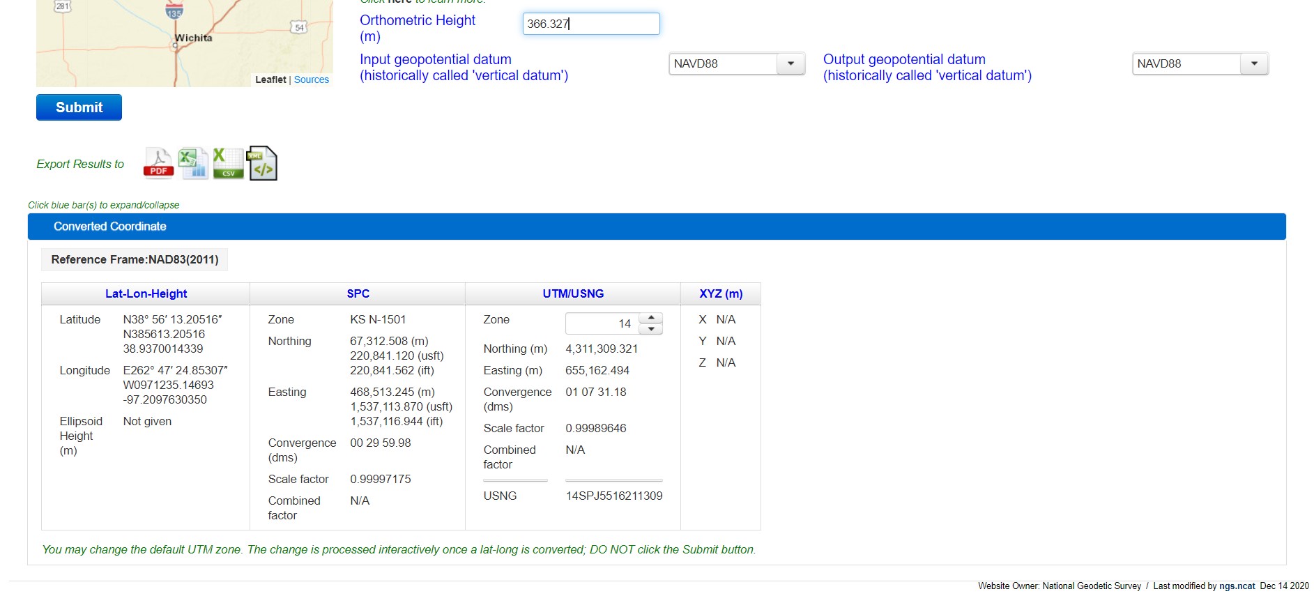
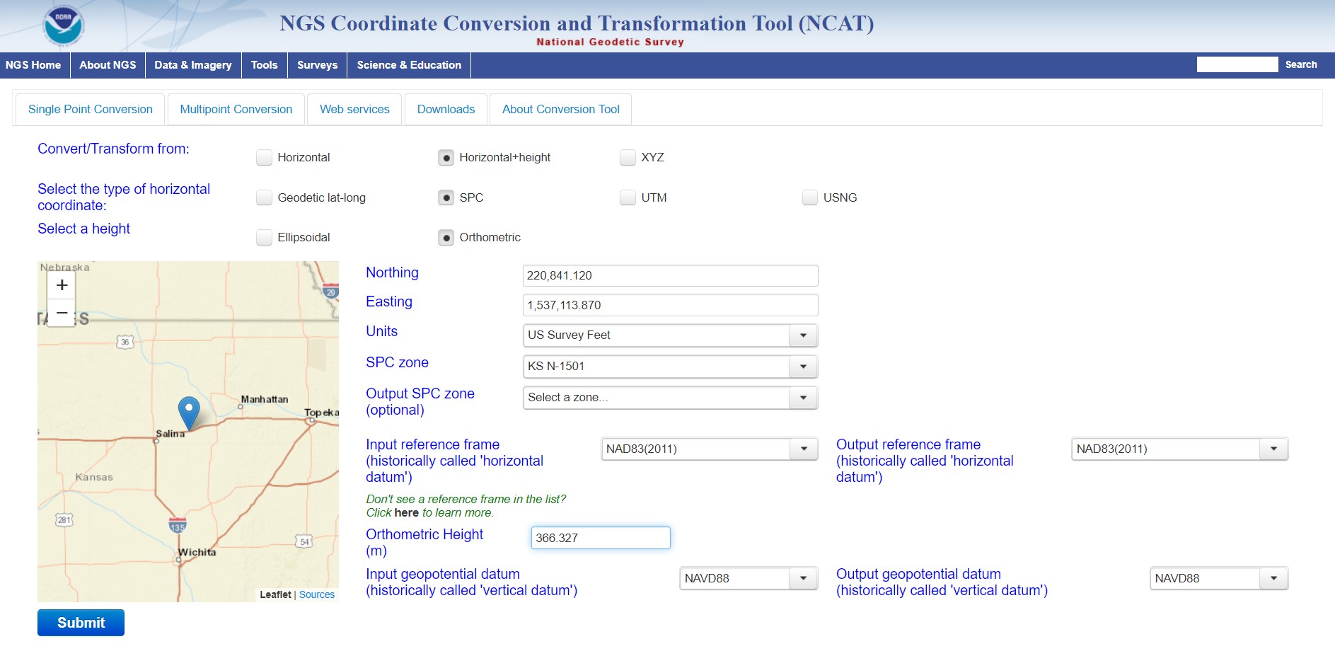
I used the NGS conversion tool, and that produced close to the same results as I got with earthpoint, just with a bit more precision. See attached screenshots.
My issue now is with the Z-axis. The measurements I captured were consistently off by about 93ft. I measured this difference by comparing the points I captured with my RS2 to what the surveyor captured. This tells me that there is something wrong with just converting the US Survey Feet Height to a height in meters. My known point had an elevation of 1201.86 US Survey Feet and I converted that to 366.328 meters.
Possibly because ReachView uses Ellipsoidal height only, not Orthometric height, much less Geoid height.
Not for certain, rusty here… and haven’t looked at the new coordinate system features in ReachView yet… still using FieldGenius for all of that externally.
It’s always (almost) geoid undulation! It will come as a reflex after a while. When Z is wildly off, verify what the undulation is for the area first. I entered your coordinates, near I70, in this tool, with the elevation you provided. As I expected, geoid undulation for that spot is 95.74976 feet (29.192m).
So either the station you’re using for correction is using ellipsoidal heights and you used orthometric as your base coords, or the reverse.
edit
Wait, you entered coordinates manually, you weren’t getting corrections. My bad.
Yeah, you need to enter ellipsoidal heights in RV3, so that needs to be converted first.
In the USA, I guess we might as well start kicking the US Survey Foot to the curb and move to the International Foot starting 2023? (Hell, at least we aren’t forced to move to Metric! Yeah yeah, it’s easier and believe it has it’s place, but not in US surveying!).
International Foot (also commonly called the foot) and the U.S. Survey Foot. The International Foot (which we were all taught in school) is defined as 0.3048 meters, whereas the U.S. Survey Foot is defined as 0.3048006096 meters. The difference of the two equates to 2 parts per million.
To be fair, in my hobby of peakbagging, there is a kind of neatness to having integer values as peak elevations and having a slightly better vertical resolution of three (and some loose change) feet per meter makes it easier to rank summits with very similar elevations.
That’s the only redeeming quality I can find for it though.
The US was supposed to go to the metric system back when I was in school in the 80’s. I wish we had, I wouldn’t need both sets of tools still (SAE and metric)
As for surveying, I would learn it. I have always preferred decimal feet that we use in surveying as it works just like the metric system, 10 tenths to a foot.
I was working already when all that happened. In fact, my boss’s boss was a member of the international committee working to bring metrication to North America. We all hated the idea - nobody likes change… But in the end, Canada switched and the US didn’t. But major industries on both sides of the border did or didn’t. (eg with a few exceptions, the whole auto industry switched, the whole construction industry didn’t.) What a mess…
Anyway, I once wrote a chess program to run on an hp calculator (hp41), and accidentally discovered the magic of octal. (it just happens that a chess board is 8x8). But Octal is also a perfect multiple of binary. Almost all math is WAAAY easier with octal. Division and multiplication are just shifts, not tables. Almost anyone could do complicated math in their heads! If we humans had only left our thumbs out of our math, we could have built a vastly superior math system based on our eight fingers than either metric or SAE (or the kings foot). Insert huge big sigh here…
In the meantime, here I sit, an old man in Canada, near the US border, born into the world of the kings foot, forced to learn metric, pretty much numerically multilingual, reading about surveying preferences with metric feet (decimal fractions), and wishing we all counted in octal instead. Gotta wonder why the world didn’t switch to decimal time too… Life is wonderful!
Sorry for the distraction. Just couldn’t help myself.
Most Surveyors around here don’t use any GNSS equipment or if they do they don’t publish any coordinate values on their maps. Most around here don’t know the difference between “ift” and “usft”. Our State Plane Coordinate System here in SC uses either “ift” or meters. There’s a big difference if using the wrong foot definition when converting feet to meters.
I’ve tried to get everyone onboard using GNSS equipment and State Plane Coordinates. It’s hopeless, the old coger Surveyors don’t want to learn or invest in new equipment. The learning of new software, methodologies and equipment is what keeps me going in this profession at 63. It’s their loss and my gain. I’ve even gotten work from Surveyors that need their projects tied to the grid system.
If using the wrong foot in conversion from meters, there will be significant difference in coordinate values between “usft” and “ift”. The international foot is the official unit of measurement in the SC State Plane Coordinate System. Most of the conversion routines by the National Geodetic Survey here in the USA and NGS OPUS give the units in meters.
I had a Surveyor question my coordinate values publish on a final project map that I had recorded in the register of deeds office when he was surveying the adjoining parcel. I explained the difference and he was surprised that there was two different values for the foot definition. He said he always wondered why his coords didn’t match published information…
Just curious, what is the history of these two feet?
My own shoe size grew enormously as a young fellow to a size 13 at 12 years of age. Then they shrunk to a 10.5 as my arch grew back and stayed that way for the majority of my adult life. Now in my senior years I’m back to a 12. And no, while that relates to my Susquatch moniker, it’s really because I am a big hairy guy that got me that nickname.