Does anyone know if Emlid has enabled continuous data point collection at fixed intervals in their apps yet? And view it on a satellite map in real time?
For me, This is an absolute necessity. I don’t want to have a rover that I constantly have to stop and log a point manually every single time.
The other thing I’d love to know is if the apps allow for real time logging on a satellite image so you can actually see what you’re logging and where you are on your site.
Any feedback on this essential feature, or an ETA when it will be implemented? Not sure I’ll be purchasing anything until this becomes a staple feature.
Not in the app, no. But the rover’s position is streaming at 1Hz or faster, so many third-party apps will see the position and record live “GPS Tracks” like that. Just enable mock-location on the mobile device so the app uses the rover’s position rather than the mobile-device’s position.
e.g. hiking/biking/boating apps and others…
And if you want to keep an Emlid workflow, you could just use said app only as your real-time visualization tool. Then for your actual data, use the .LLH (long/lat/height) log-file from the Emlid device (which can be opened up in spreadsheet software or imported into a GIS or CAD program).
At present, Emlid Flow does not support collecting points based on fixed time or distance intervals. We do have plans to add this feature on our software, but I can’t give you any exact ETAs at the moment. Once there are any updates, I’ll be in touch.
The other thing I’d love to know is if the apps allow for real time logging on a satellite image so you can actually see what you’re logging and where you are on your site.
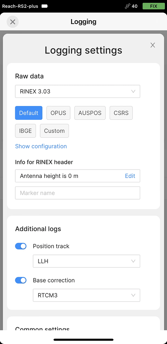
While we currently don’t support this feature yet, in the meantime, you can record a position track log in Emlid Flow Logging > Settings > Additional logs > Position track :
We are definitely looking for these initially mentioned features now, as they are massive time savers in the field. Without an approx. timeline to market, that does not provide any hope nor ability to plan a viable purchase. Unfortunately I think we will be forced to look elsewhere for our receiver needs.
It’s not a limitation of the receivers… it’s a limitation of the software. Emlid Flow is very basic. You will definitely need to look into 3rd party software/apps.
Take a look at Microsurvey FieldGenius survey software. It can do this easily using Emlid receivers and other brands.
You are not going to find equipment priced as fair as Emlid products unless you hobble components together, chinese alternatives or a five-finger deal.
What @ceith mentioned are actually good options. You can do this (GPS Tracks) using GoogleEarth on a Windows tablet also.
As @timd1971 mentioned, this is not a receiver limitation, but of the app. We are constantly working to expand the capabilities of Emlid Flow to support a wider range of surveying workflows. In the meantime, you can integrate Reach Receivers with other third-party software to address specific needs that Emlid Flow may not yet cover.
I would like to know how many points can be collected per second with this feature. I have a project to map 2D objects with short intervals between GPS points. For example, can we collect 10 GPS points per second?
Not sure, but maybe Emlid can verify? Maybe depends on the Hz frequency Rate set? I think the max is 5Hz for the RX??? (so 5 points per second??) 10 Hz depending on settings for the RS2/+/3 M2?