Have been messing around with PPK on a Mettatech PPK kit. Logging on the M2 is very easy for the “Rover”, and i have been using a Topcon Hiper VR for the base. After processing the PPK data and using pix4D i am getting a 33m error on Z. Will the RINEX logs automatically be in the same projection for the base and the rover, or do i need to specify it?
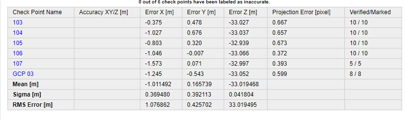
What kind of PP software are you using ? Looks as if there is a missing geoid model as the vert error appears to be about the approx geoid separation from the ellipsoid.
If you’re just PP with base and rover, just use your base mark coordinates with antenna height as “fixed” and import the rover data with antenna heights to PP. Whatever datum the base coords are in is what the rover points will be after PP. If you don’t have a “true” base coord, simply PP the base with a CORS station and translate the rover points to the corrected base coords .
Looks like all the horz positions are kind of sloppy, approaching almost 2m in error. I would also look at the raw data and see about cycle slips in the data. Your accuracies aren’t good
It seems that i cant input eastings and northings as the base location in Emlid studio. When i import the base data it detects the following from the Header position:
Emlid Studio will only use WGS84 geographic coords. You can PP and then later transform to the appropriate projection with geoid model needed. I’ve only used it a few times experimenting with the beta releases.
If you’re doing RTK in the field, you can select the projection needed along with the geoid model to download. This will apply the geoid separations so you’ll have true orthometric heights for your located stations.
I use commercial PP packages Javad Justin, Justin 3 and also Trimble TBO as they have multiple baseline processing capabilities and adjustment routines. I’m hoping to start to play more with the Emlid Studio v1 release… they have come a long way.
I would suggest reading Emlid’s docs on methodology and processes. I’ve learned a lot since investing in our Emlid equipment for the last two years. Their instructions are well explained and thorough.
I agree with Bryan that you obtain ellipsoidal heights instead of orthometric ones. Since Emlid Studio works only with geographic coordinates, you need to apply the projection and geoid model to convert them into the local coordinate system in Pix4D. To learn more about Pix4D workflow, you can check our guide.
I assume that your points have relative accuracy. However, you need to get absolute accuracy of the entire dataset to avoid such errors from the initial post. If you record the base position via NTRIP in ReachView 3, the output CSV file contains geographic base coordinates as well as the local ones in GDA94 - Zone 52. Input them manually in Emlid Studio instead of taking ones from the RINEX header, and you’ll obtain absolute accuracy.