I aerial surveyed a site using Reach RS+ as base and Reach Module as rover to lay out GCPs. I didn’t have enough time to setup the base for PPP observation first. So, base position was single averaged over a couple of minutes and after it is established, GCPs were laid out using Reach Module rover.
However, I did actually find time to run the Reach RS+ in PPP mode for 3 hours while the drone was flying and my team working on other stuffs. I uploaded RINEX to NRCAN service and received calculated position.
Now I want to transfer the whole network of GCPs’s coordinates surveyed with reference to the base station’s averaged single position to the one which NRCAN calculated for me. How do I actually do the task? Is there any software for that?
@EBE111057, Thank you for your suggestion. This is the first time I ever heard about a COGO package. It would be the best if I can obtain a free package for that.
To be honest, averaged position and PPP position of base station are off by just a meter or so horizontally. Do you think the elevation data would not be affected a lot?
I would love to learn more about these topics. Could you point out any good books or websites where I can learn these?
This shouldn’t be very difficult at all. Everything should be a relative shift and if you’re using decimal degrees should be an easy transformation in Excel directly on your points list. Including the vertical.
What makes you think this is even necessary? How is the Drone data being used on the back end? Is it having to be aligned to any other CAD or design data? Will that latitude and longitude even line up with the CAD? There may be shifts and scale factors involved in that as well so it wouldn’t even really matter.
Thanks Bryan @EBE111057 for the remark, I totally forgot about the élevations
Indeed If we assume that Zc (corrected height) for a Base station and Zo (old one) DH = Zc - Zo
where ZGCPc is a corrected height for GCPs.
and ZGCPo old height. ZGCPc = ZGCPo + DH
you can do these calculations very easily using EXCEL as mentioned by Michael above.
Yes of course and the calculations will be simpler if you convert the coordinates from Latitude Longitude to WGS84 UTM format.
As Michael noticed, to get the corrected coordinates, you need to shift all of them along each coordinate axis by the difference between the averaged and the precise position. You can do it using Translate feature in GIS, manually, or try one of the suggestions mentioned above.
Please note that the single-band receivers such as Reach RS+ can provide only about 30-cm accuracy after PPP.
Hello Michael, thank you for your advice. I am going to input these coordinates as GCP coordinates for my drone aerial mapping and resulting DEM/DTM and ortho maps will be used in further field studies. (Not for construction/civil engineering purposes.)
And in the future, I am going to get more precise coordinates of the base station with help of engineers from government land survey dept. and I will need to update the coordinates again. They have benchmark/control points in the same region of the survey site, but we didn’t have much time to transfer from control points to my site. At this moment, the base position is barely an assumed position, but I want it as precise as it can be since I don’t know when we will be referencing land survey dept.'s control points and updating our coordinates.
Would you mind pointing out any transformation formula for Excel? I have coordinates in UTM. Or is it just a simple case of finding delta x,y,z by comparing two base coordinates and apply the same delta to other coordinates?
That’s the way to go. It depends on your circumstances, but ground does not always match grid, especially on the Z-axis. In construction we are given benchmarks specific to each project and it is not uncommon when you get a new project that might be directly adjacent, but comes off of different benchmarks. Or the two benchmarks provided in the plans don’t match each other. This is why we do a localization process so that we never have to worry about any discrepancies on coordinate basis.
There typically not any rotation so the difference is just coordinate geometry and a static value. +/- X and +/- Y… Z is the one you have to research or as you said get from an Engineer or Surveyor.
The only thing you have to watch out for beyond that is scale factors and it is a linear shift.
I hope the difference in averaged and PP position will not be that much. For our purpose, 30-cm accuracy is still much favorable.
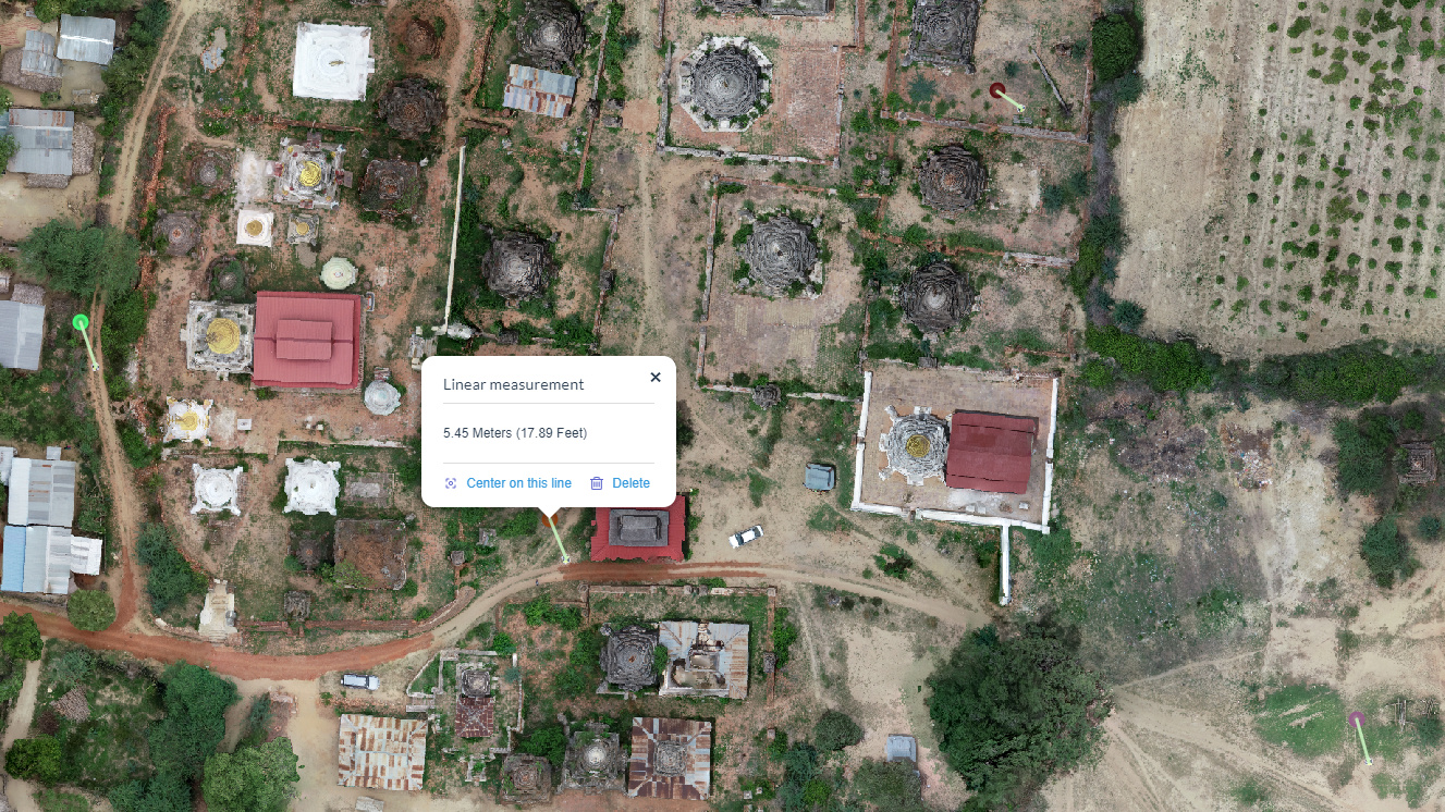
At this moment, the ortho map generated from aerial photos and drone GPS tags alone, shows visual GCP markers are about 5.5m on average away from our surveyed position. I will perform the transform and use it as a GCP input to ODM software for better georeferencing.
I’m helping a local archaeology community to generate ortho and DEM maps of a site for inventory recording purpose.
Could you point out any books or materials where I can learn in depth about these subjects? I am not a survey engineer and not working for any engineering projects that requires engineering professionals and experts. I would love to help out local communities, but I want to do it in a way that is standard and formal, properly planned and carried out, so that my contribution can be in proper format and useful for further applications by people who might need it.
Unfortunately most of this information is experienced. There are so many types of hardware and software that work a little differently that there are allot of different ways depending on what your end goal is. I am happy to be a resource as you progress.
Understanding that you are drone mapping is another thing all together. The survey gets you established, but what you can do in processing really decides your accuracy. I would encourage you to join the DroneDeploy Forum (forum.dronedeploy.com) as there are allot of resources on surveying for and processing of drone maps and models. I am a moderator and linked pretty much all week.
There is an alternative way to do this if all you are needing is relative map to map accuracy. Keeping inventory and performing volumetrics does not require absolute global position and there are other ways of doing GCP’s where your data will be sub-decimeter accurate.