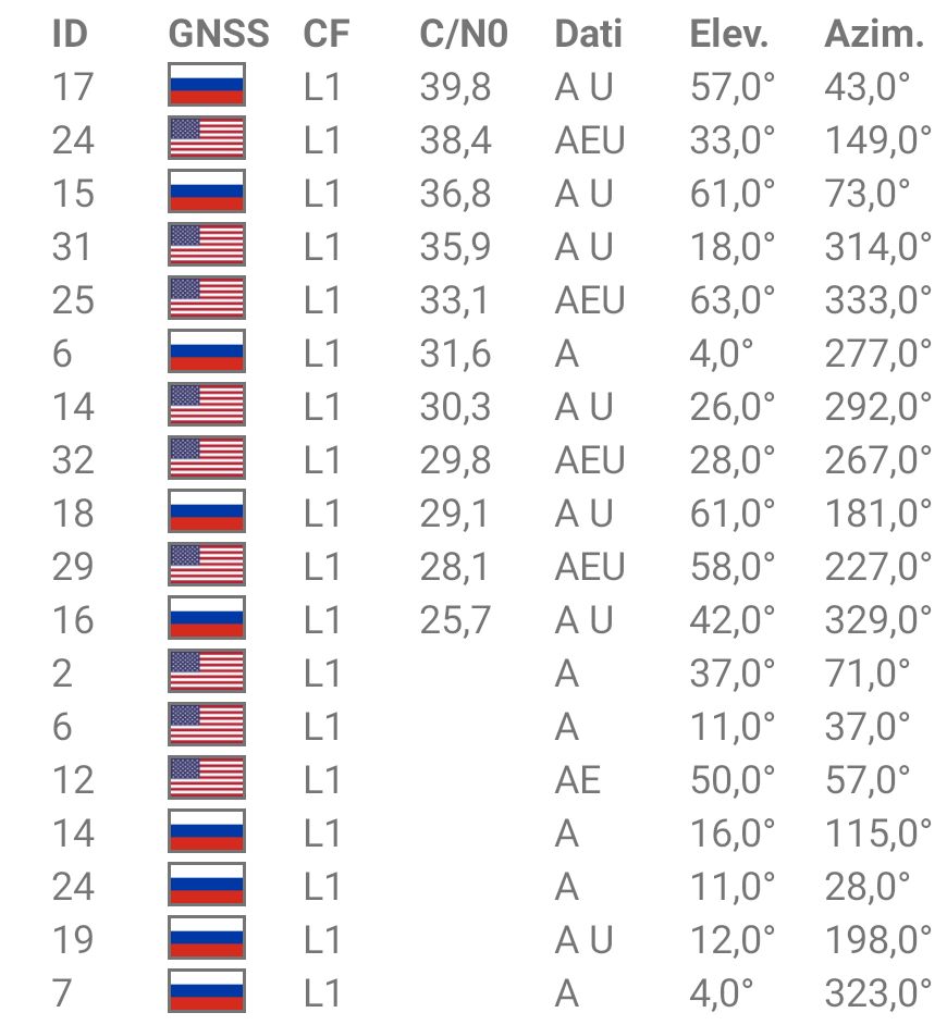
This is the situation of the sky in 2 very unfavorable points.
Can I think of using Emlid products with these visible satellites ?
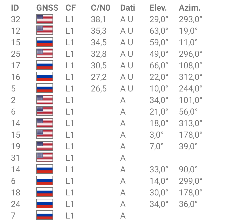
This is the situation of the sky in 2 very unfavorable points.
Can I think of using Emlid products with these visible satellites ?
It all depends on your environment. What have listed above are best-case as far as SNR goes.
Show us your location in a few images instead.
You probably need to be evaluating your cost and rule out anything that is obviously out of budget reach? Then you may end right up with (1) RS2 or (2) RS2 and/or a new Total Station maybe if you think you need it in conditions where GNSS just may not work at all?
RS2 $1899 (new)
or
Trimble R10 $1899 X 10 = $18,999 (used) You also need to get a Trimble Data Collector and the software that only works with it. I don’t know, maybe $40,000 (used)?
wow
Can you just use a drone and use gcps in the areas where you can get a fix down there and the ones you cannot, just use gcps above it that get clear sky view?
The base can always be in a position with all the visible sky. So, no problem.
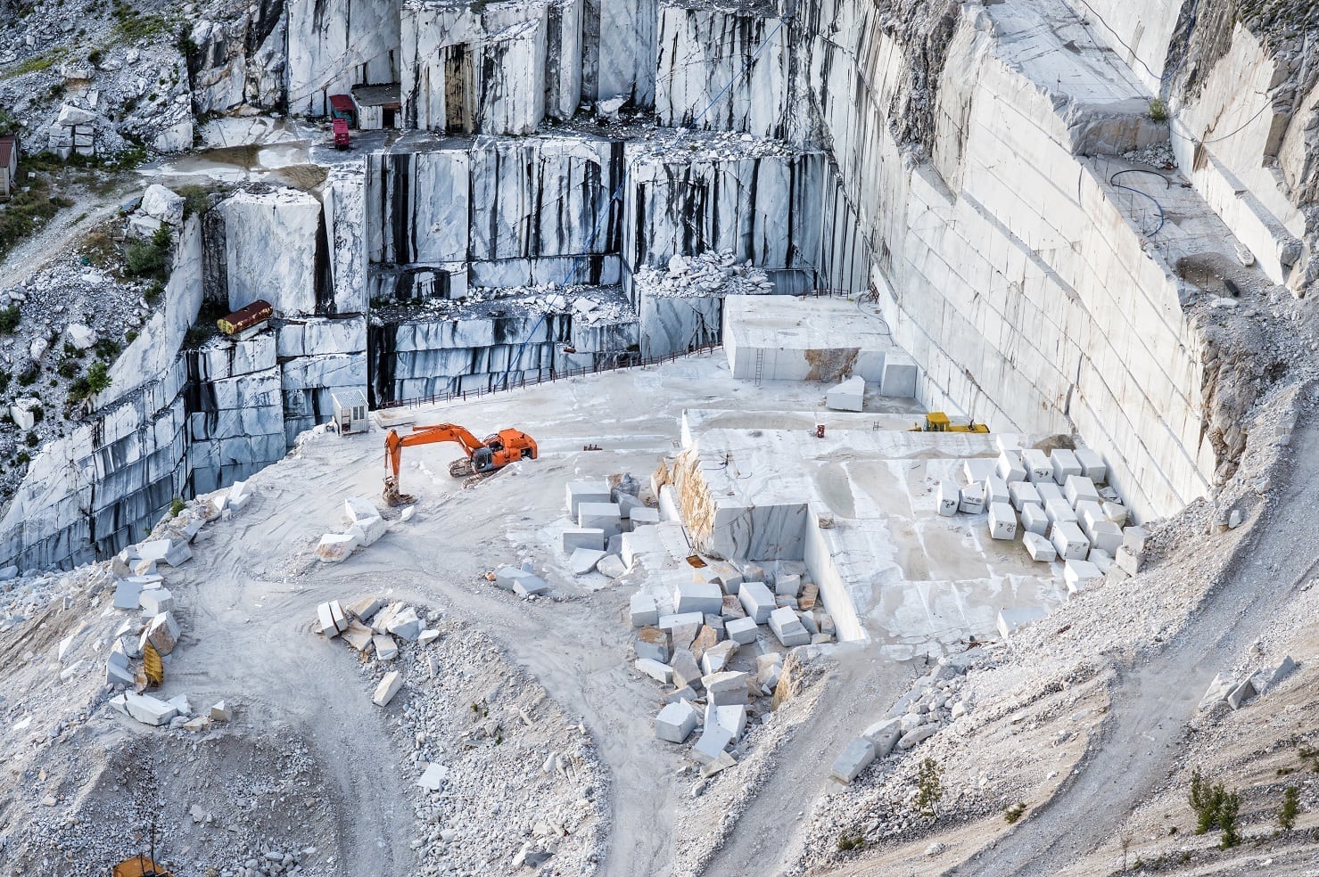
Regarding the placement of GCPs, I observed that I get a very good final result only if it respects a certain pattern. 4 GCPs must always be placed at the angles that describe the boundary, some GCPs scattered at variable heights, at least 1 GCP is required at the bottom and in the center of the pit.
My concerns are on the GCPs on the bottom…
While you might be able to get a good position from an RS+, given that the isn’t too narrow, and you have enough time to observe on each point, an RS2 would offer more flexibility in situations like this.
However, if you want to be sure, you should confirm the measurements close to the walls with a total station.
If I have to check the measurements with a total station, then I can take measurements directly with a total station…
I thought that, not needing high precision, not requiring georeferencing, with just an RTK drone I could get a model to “measure” … unfortunately it doesn’t seem to be like this ![]()
Isn’t there an alternative ? For example some sort of scale constraints ?
What region of the world are you in? Maybe a dealer can help you to see what Emlid devices work for you? I.e. Australia: @alistair ww.mangoesmapping.com.au
I’ve reflected a lot on my real needs, on what the market offers and on the various prices.
Evaluating pros and cons, costs and budget, I decided that for the moment I will continue to use my “old but good” total station… BUT connecting it to a modern (portable) interface software in order to update the workflow and speed up the process.
I believe I will consider an investment in a GNSS system only if it can be perfectly integrated into a drone and will allow the GCPs to be totally eliminated… until that day I think that the total station is the best compromise for my needs…
For precision work, that will likely never happen. Too many variables in an aerial platform.
You will be able to minimize the number of GCP with a PPK-solution like the M+, but it still needs GCP’s for control and check.
It will probably be so… but maybe if you can accept an error of 10 cm, who knows ?
However, more than “coordinates” I need “measures” and, even considering the environment in which I operate, I believe that laser technology remains the best for my needs.
The problem is the total station I own, from the 90s, still perfect in making measurements, has a crappy user interface (I hate it). I found a way to replace it with a modern touchscreen interface and I think it’s the best solution right now.
10 cm should be perfectly doable from an aerial ppk platform, if you have a clear skyview, which you should be able to have from a drone anyhow.
What solution did you go with?
If the flight speed is not “very low” there are too many unmanageable errors, especially with the non-professional cameras of commercial-grade drones. I must be sure that the final result is correct…
Through a simple serial-usb adapter the old total station can interface with all the modern “touch” software… SurvPC, Fieldgenius and many more…
…and with a Carlson controller and Surv PC, you can use your ReachRS+ or RS2 to make a hybrid prism/GNSS so your total station follows your prism, even when you move behind obstacles such as excavators or blocks of rock.
We recently demonstrated this integration with an RS+ and Surv PC at the Carlson Booth at the Australian Institute of Mining Surveyors national conference in Sydney.
This topic was automatically closed 100 days after the last reply. New replies are no longer allowed.