Building a House

Hello, I am new to the forums and want to run past the community what my project is before I pull the trigger on a purchase. Sorry that this may be a long post, but I have bunch of questions!

My wife and I are building a new house next year. We have a 14 acre field we purchased. The land was just surveyed 3 years ago, of which we have the drawings of. The longest property line is nearly 2000ft long due to the driveway “right of way”.

Regardless…

I designed our house in a program called Home Designer Pro, and am semi-proficient in AutoCAD. So I exported the design into AutoCAD to place the Well, Geothermal, Transformer, Buried Propane Tank, Septic, Conduits, Patio, and any future buildings like the Detached Garage, Pool, and Pavilion. And here is where our struggles begin.

Staking off all of the above items on a crowned piece of land, when you have no reference to any of your property pins near by is very frustrating. Can Reach help me with this?

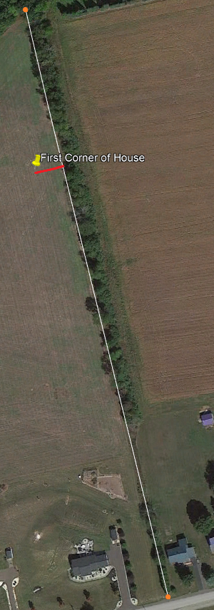
What I want to do is purchase a Base and Rover. I’ll place the Base at the top of the property, then using Rover, mark the property pins set by the surveyors. I found the pins and they are easily accessible. I’m hoping then, I should be able to find the property lines anywhere between two points. I attached an image below explaining what I am in need of. The two orange dots represent the pins set by the surveyors. The red lines represent what I am needing to measure. This is the first task I would use Reach for.

If the above an be accomplished to within a few CM, that would be awesome! I should then have no problem bring the coordinates back into AutoCAD to reference the rest of my drawing. Turning all the lines and corners of the drawings into headings and coordinates.

Could I then upload them to ReachView so I could walk the land with the Base/Rover to stack everything out???

This will also give me historical record of everything that is buried, no? I should be able to go back at anytime with the Base/Rover to find a buried item, within a few CM right?

1 Like

It’s that you cannot, but probably not recommended? Probably best to hire a surveyor or contractor with a total station and save yourself the headache?

Let me be clear though…

I’m not wanting to use Reach for anything that will be used directly for construction by the general contractor (I.e.- Foundation setting) or sub contractor(s).

This is more or less, being used for “property layout” at a higher level of accuracy than what your average hand-held GPS or Smartphone will get you.

Why not contact the surveyor(s) who did the boundary in the first place ? Most surveyors today are very proficent in AutoCAD world and some will even supply the digital file. Some may have even tied the survey to the NSRS. I’ve had landowners do the same and try and use their consumer grade receivers for the same use you want to do. However 99% claim to have worked for a “surveyor” and know all about surveying untill they get in over their head. They don’t seem to understand the difference in their consumer grade vs survey grade receivers or even the concept of actual boundary surveying.

If you’re trying to do any kind of amateur surveying with the boundaries of your property, keep in mind that those boundaries are also your neighbors’s boundaries. If you make any kind of mistake in staking the lines or moving or resetting property corners, you will find yourself in a lot of trouble with your neighbors and financially with possible legal issues.

2 Likes

I have used a pair of RS+ devices to do a very similar workflow. The net result is a set of points in CAD can be transferred to Reach and a set of collected points can be transferred to CAD using state plane meters to lat/lon conversion including elevation with repeatable cm accuracy. All for personal layout purposes. Parts of the workflow are automated and some manual calculations too. Let me know if you are interested in seeing or learning the process. I’ll check back on this thread in a couple of days.

It doesn’t sound like you have the software to create points but as you have brought the project into CAD you can export to DXF and import into QGIS to create a file. If you have 3 pins not on the same line you can fairly easily stake this yourself. If you don’t have the points or plan on affecting drainage adjacent to your property then it would be in your best interests to hire a Surveyor. This would all be easier if you had a drone and could make a much higher resolution map which can also be used in QGIS. Then you could easily get the house located to within a foot of where you want it.

You will almost surely have to align your CAD with the points you collect. I do allot of conceptual designs and layout for private parties, mostly friends of our owner. I can do anything required unless they are in or close to a floodplain or you can’t find any monuments.

1 Like

Keep in mind doing this before the infrastructures are put in won’t yield a perfect result for locating buried things in the future. There’s a reason an “as built” plan with measurements taken as the stuff is installed is important if there were reasons for the contractor to deviate slightly from the drawings. You can plan with this but for your secondary goal, you’d have to go everytime something new goes in unless the contractor can do his own measurements.

I’m not real clear on your meaning here, but if you can get a point out of CAD you can stake to it within cm in the field. If a utility is installed in such a different place than it was designed then we have other problems.

Maybe it’s my experience from difficult terrain but I’ve seen septic tanks and pipes get nudged a couple feet when lumps of bedrock would show up when dug out.

This doesn’t happen at our company nor do I believe our competitors are having this issue. There are practices in place that mitigate conditional error and our area ranges from fat clay to hard limestone. Even further we now have GNSS machine control on all of our excavators so trenches and grade are at a 0.25ft spec. Surface structures are held to a tenth both horizontally and vertically. I really feel for anyone that comes behind companies other than these.

1 Like

Seems like an expensive way to go about it but at least you have a base rover setup to keep at the end of it.

For a “rural” lot like that I’d be happy setting out where everything is designed to go using GPS and coming off your lot markers, this isn’t urban shit that requires millimetre accuracy so go right ahead. I imagine they probably tied in the existing feature survey to the boundary pegs too so you could combine it all into a single cad file.

Note: Based off the assumption your pegs are correct

As the services go in just ascon it as well, pretty standard practice

Hahahaha! :rofl:

Justin, you summed it up nicely.

Not looking to use this for anyone but myself for house layout and infrastructure layout. I live close by and anticipate marking components as they are installed as much as possible.

My main concern before pulling the trigger on an order of RS+'s is repeatability.

Without the use of Ntrip or a local known reference point, from my understanding the Base & Rover can still achieve the few cm’s of accuracy?

The first thing items I am going to mark are the pins set by the surveyor, followed by two corners of where we think we want the house. Then bring them back into CAD.

1 Like

You can do an averaged in point and document it for manual entry in the future and you will maintain relative accuracy.

Hi RedDot,

Like others have already replied, if absolute Lat/Lon is not important then pick a location with good sky view to place the base and let the base try to figure out the location. Note the Lat/Lon/Elev and set those values manually even if you only get single because you are good with relative. That point becomes your relative base location. The rover will then receive corrections from the base and you should obtain repeatable cm accuracy. I am amazed at how well this setup works, really, just like it should.

I imagine you will be using LoRa for communicating corrections. I have not had great success with LoRa so I use NTRIP. However I set up my own server. I use the free registered version of SNIP ( https://www.use-snip.com/ )… The SNIP server receives corrections from the base and the rover gets the corrections from the SNIP server. Since there is likely no WiFi at this location, your situation would require two cell phones, one for each unit. There are a number of steps in setting this up including configuring your home internet router. If you run into trouble with sending/receiving corrections I can help you set up a private NTRIP configuration.

1 Like

I mean, majority of times I find rural lot markers that are still present in the ground are within an acceptable tolerance so :man_shrugging:

RedDot, have the surveyors tied in your boundary to real world coordinates? if so I’d just setup a nice base location and place a marker there, average the location for a few minutes then pickup the boundary marks. Shift everything in cad then update your base coordinates and you’ll be tied in for cadastral and be georeferenced as well

1 Like

Every use-case has different tolerances but just because a pin seems in your tolerance doesn’t mean it going to report that with a localization taking all the other pins into account. Nearly every project we do has at least a couple of pins that are outside of our control tolerance. On top of that it is rare for a land title survey to be using State Plane. There’s really no excuse for it present days but back when I was doing it calc points on an HP48 every southwest corner was 5000,5000,500.

1 Like

Hi @RedDot4679,

Welcome to the community forum!

With our receiver, you will be able to locate points with centimeter-level accuracy. I see that you know it needs to get corrections from the base. As the guys wrote before, you can transmit corrections between the base and the rover via LoRa radio or the Internet. I can’t comment on the SNIP server as it isn’t ours. As an alternative, we have Emlid Caster, which allows you to transmit corrections between your base and rover over the Internet. You can read about it here.

If the receiver gets corrections, it’ll determine the coordinates with centimeter-level accuracy. The main point here is that the rover is determining them relative to the base. If the base is set to a point with precisely defined coordinates, your accuracy will be absolute. I guess if the pins set by the surveyor are attached by a peg and have known coordinates, you can use one of them as a point for placing your base.

Our receivers allow you to both collect points and stake them out. You can import points into our ReachView 3 app to find them on your property. One thing, for now, our app only allows you to import and export CSV files.

I don’t know how land services work in your country, but it’s quite a complicated process in ours. Probably Bryan and Michael made a good point about surveying services.

2 Likes

This topic was automatically closed 100 days after the last reply. New replies are no longer allowed.