Base position

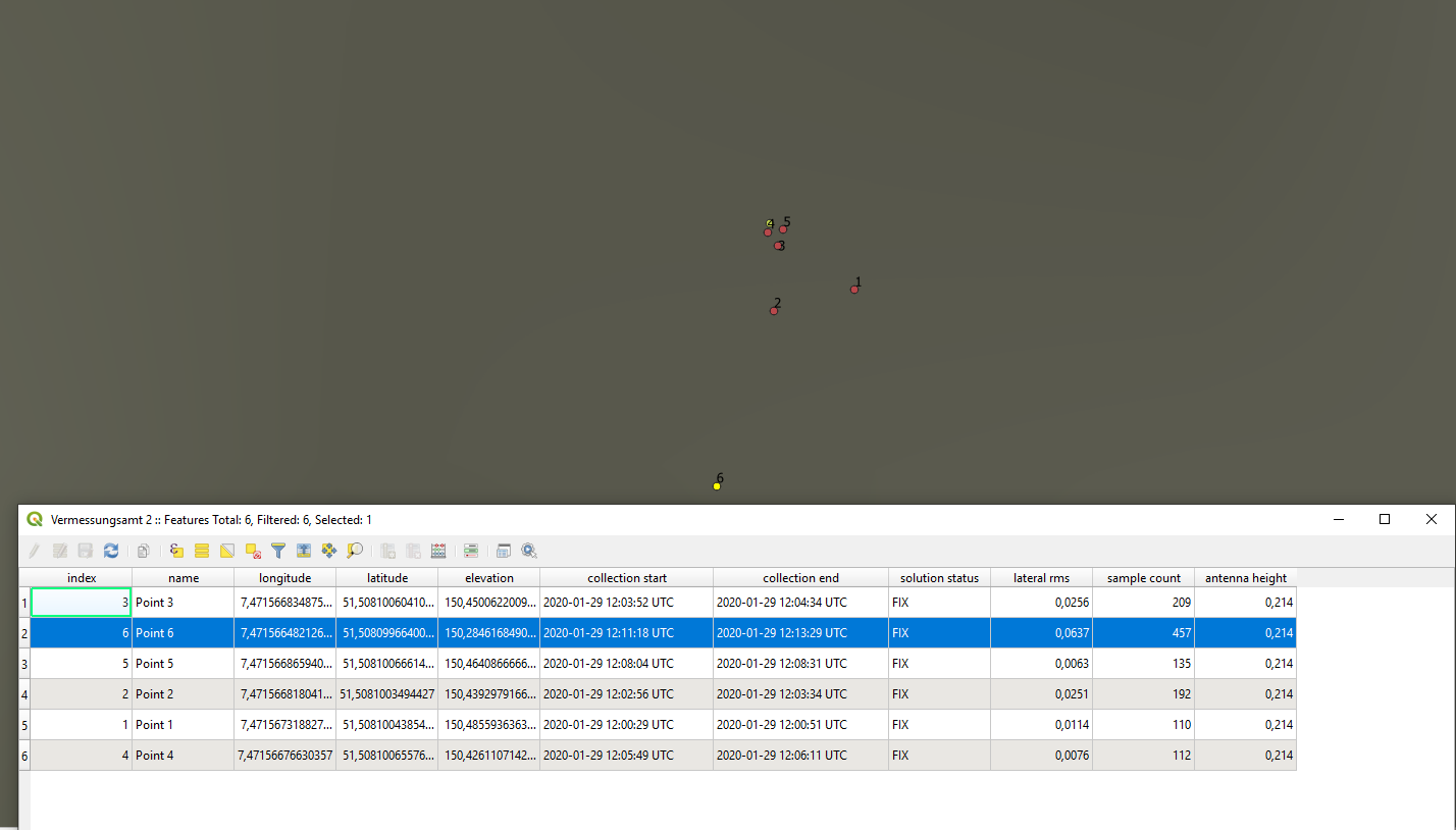
I made a small reference survey to check the accuracy of NTRIP. Location was not the best, 270° skyview, the rest blocked by a building. I have the exact coordinates from this survey point.

I used the survey module in reachview and collected a few points with different lengths:


Upper yellow point is reference…

Interestingly, the shorter the averaging time, the better the result. If I get it right…

The furthest point is 12 cm afar, the 3 closest around 1 cm…

Now what I would like to know from you, is : How can I get the average receiver position to compare it to the points CORRECTED with Ntrip?

The pos file is a miracle for me and I don’t understand what it is supposed to mean.

solution_202001291158_XYZ.zip (76.4 KB)

And the Rhinex raw logs are 90 cm off… So I guess they are uncorrected…

raw_202001291158_UBX.zip (97.0 KB)

Is there a way to see the average fix position over the entire collection time, corrected with NTRIP?

I researched the forum a bit because, to my understanding, it should be possible to correct the raw logs with the Rinex correction from a local station. As it was mentioned in 2018 here in the forum the PPK tutorial mentions the possibility to do this BUT there is no tutorial on how to do this.

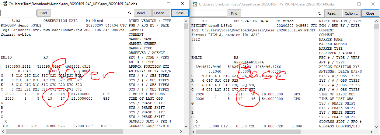
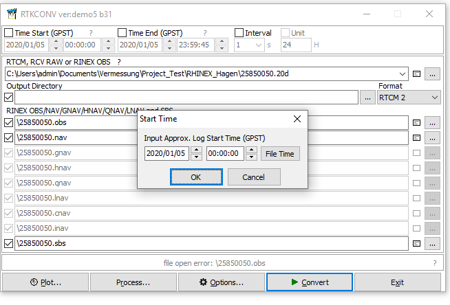
I have downloaded the Rinex logs from my closest reference station but I am struggling to get the OBS file from RTKconv.

This is the Rinex file (2.11) from the caster station
base_202001051248_RTCM3.zip (574.7 KB)

and this is the base station (RS2) log:

raw_202001051248_UBX.zip (8.0 MB)

I get an error when I want to convert Rinex logs from the caster station… It always wants a start time and I put in the start time from the log file but it does not eat it…and does not process it…
Can a good soul please take a look and point me into the right direction?

Many thanks

Those two files doesnt overlap in time, so it wasnt possible to process.
Do yo have another file you can use?
Rover to the left, base to the right

2 Likes

The RTCM base file you used here, is this from a service? and if you can download another one hour later?

1 Like

Sorry, i uploaded the correct Rinex file in the original post. It is actually the corection log from my RS2.

This is the log file from the NTRIP provider station nearest to me (around 30 km)

25850050.zip (1.6 MB)

When I try do convert the Station Rinex2 file in RTCONV, I always get asked about the start time and it subsequently ends on error:

This is the text file that comes with the station logs. Start time is 2020/01/05 00:00:00 as far as I can see:

2020-01-05-warino.zip (46.2 KB)

The file is already Rinex (2.11) , so you dont need to convert it.
It is also at 30 sec interval which makes it hard to use it for anything els then static operation, i noticed your rover is a RTk session doing dynamic point (moving around).

Base data contains info about the base coordinates system, use Rinexheader and the output you get after PPK rover should be in the same datum the base station is.

2 Likes

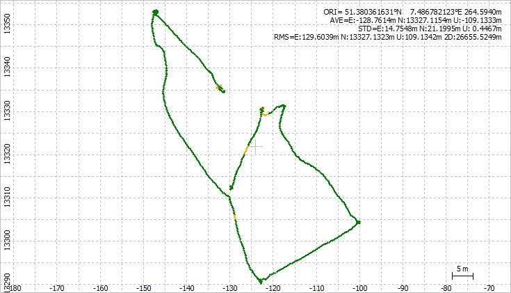
Here is the track and .pos file.
Somewhere along this track is the points you are looking for.
You should split the time periode and process it static for those areas that has a non moving rover and you want to extract the static position.


raw_202001051248.pos (1.0 MB)

1 Like

You did that with the corrections log from RS2 or from Caster Station logs?

And thank you!

With Caster

Hi @kasanmascheff,

I assume our Understanding PPK solution and analyzing logs from Reach article might be of help for you as it describes how to examine both raw data and RTK/PPK solution files.

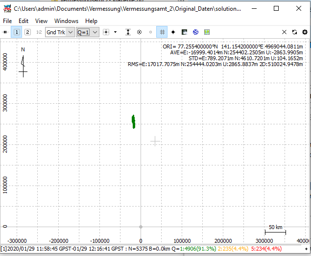
Once you opened the solution file in RTKPost, you can check the ORI field in the top right corner. ORI stands for the coordinate origin and displays the average coordinate of all positions by default.

To observe only a fixed solution averaged, it’s better to cut the log to a time period containing the fix solution only. You can do it in Edit => Time Span/Interval.

This topic was automatically closed 100 days after the last reply. New replies are no longer allowed.