Hi, I’m using Reachview 3 v7.2 and I have a couple of issues about the base-rover mode and setting the coordinate point manually.
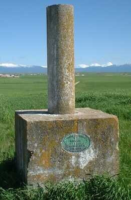
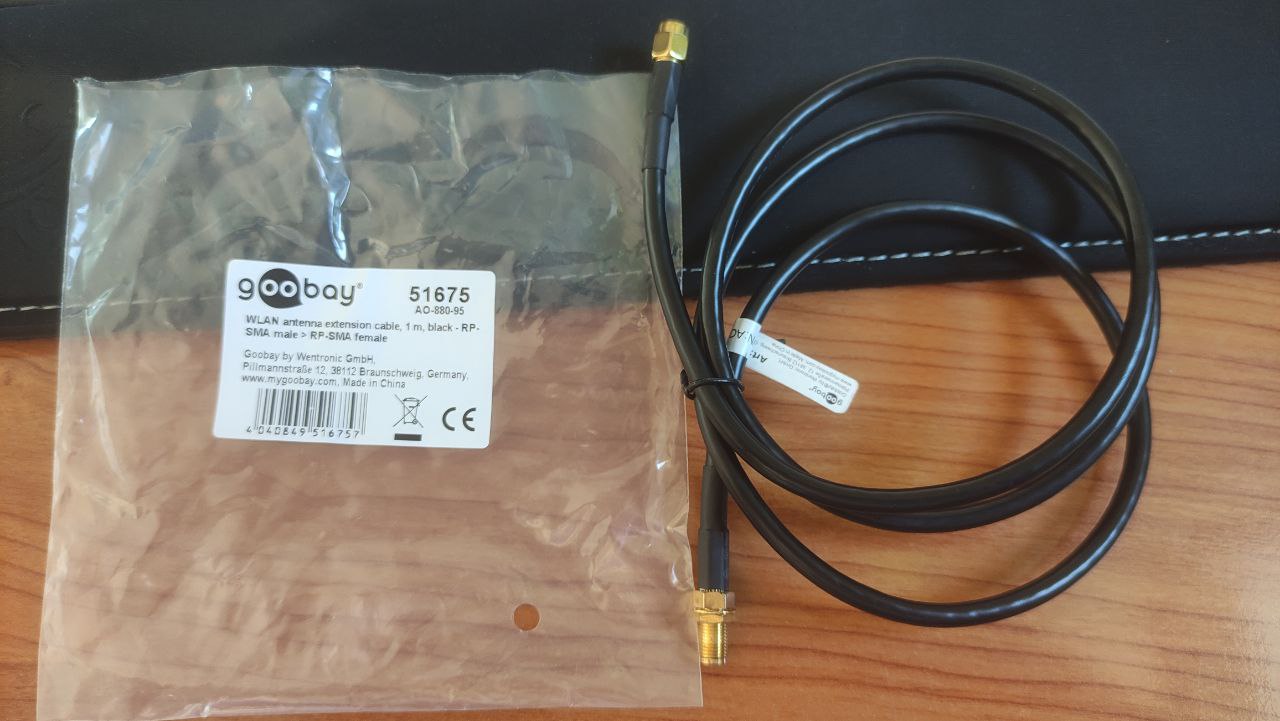
First of all, as I use in one of my jobs bases of this kind:
It’s impossible to set the lora antenna on this kind of setting so I bought an extension and might work (attach image).
On the other hand, I found very annoying, when set the coordinates of the point manually, type it manually in WGS84 format. Lots of mistakes can be made and would be much easier to take the reference point from a preload base reference archive. I have a dozen reference points in my site and I have the UTM coordinates in a file so would be great be able to select the point from a file.
Thank you for your great hardware and software!
Yep, I’ve suggested this numerous times. Although I understand Emlid’s reasoning behind their setup of the base, it’s not very useful for land surveyors and certainly not like other manufactures methods.
Just like our other name brand equipment (Javad, Trimble), it would be nice to setup the datum/projection geoid model system in state plane coordinates in Reach, import your points (they are already in the defined system that you setup in Reach), select one of the points you imported and use as base (you would see state plane coords with orthometric heights). Then proceed with the project and checkin to several points along the way.
You can input NAD83 geographic coords, ellipsoid heights the way it is now, however in my opinion this needs to change to the suggestion above. The developers are not land surveyors and don’t think like them. They’ve improved the app by light years since I started using, but they have a long way to go.
For example, we been using Javad’s equipment for the last five years. Their equipment is light years beyond any manufacturer. Their equipment is more geared as a scientific analyzer of GNSS signals. Their Triumph LS, LS+ and T3 receivers are kings in the multi-path world… I can use ours in places that the sun doesn’t shine and have a repeatable verified position. The Triumph LS was developed by Javad Ashjaee himself, the guru of signal analyzing and processing with the help of a dedicated group of professional Land Surveyors. We were one of the first to jump in on the trial program with his receiver before they were put on the market. Emlid would learn a lot from this example.
Hopefully they’re listening to us land surveyors with years of experience like me. I started in this profession when I was 14 and have used every type of equipment you can name… I know what I’m talking about .
I’ve always used Leica and Topcon equipment and they have a lot of tools and options thinking on land surveyors, Geomatic Engineer in my case. Obviously, those are much more expensive hardware and software.
But I really think that sharing experiences, needs and tips it’s the way to show Emlid what we need.
I’m brand new in reachview app use and RS2 management but I’ll give a try next time I use the base-rover configuration. I’ll let you know. Thanks for the tip!
Thanks for sharing your experience and needs! That’s what helps us make our products better.
I can say we remember all the requests for setting a base position in projected coordinates. And we’re looking into the options that can make it easier for users with any experience.
Here’s another survey guy, what i have not seen with you base shift is an angle rotational shift dialog box. This aligns the corrections to local project.
Is this Rotational correction possible within the reach view app. and be applied to the base for castor corrections to an RTK drone.
This is xyz and alignment shift is currently being applied via my data collector with rover.
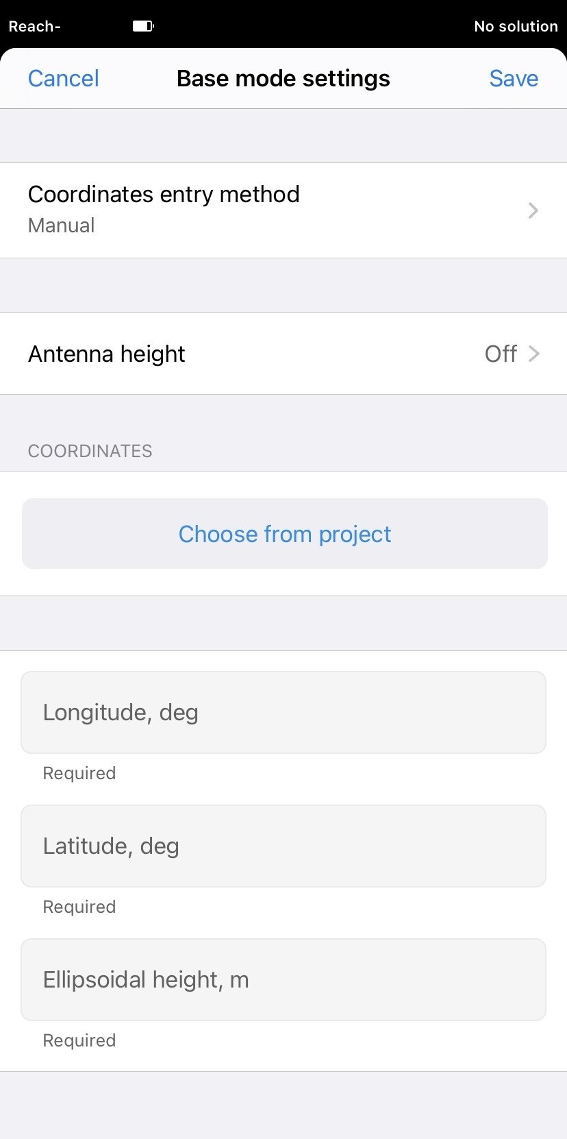
We’ve just released this feature! You can now create a ReachView 3 project with the base’s coordinates and then choose the point in the Base mode. That’s what it looks like: