Can someone give an insight regarding setting up the base manually?
The process itself seems straightforward when it comes to setting up the base in manual mode over known points.
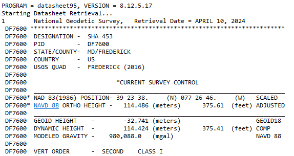
However, what confused me was that if I entered the coordinates given by NGS in Emlid 360, the point ended up in Antarctica or something similar.
Thus, I assume I need to convert the NAD83 coordinates given by NGS into a different system.
Thus, the question:
Do I enter manual setup coordinates as they are in NAD83 (my projects are in NAD83), or do I need to convert to a different system?
When I add a point in Emlid 360, do I need to convert NAD83 coordinates to a different standard even though the project is set to be in NAD83?
What am I missing?
Thank you for any advice!
PS: I did go through various forum posts similar to what I am asking, and there is some information for RS2 units. that NGS data needs to be converted to WGS84. Yet, I cannot find information if it is relevant to RS3.
…and for example for the MANUAL Coordinate entry (DMS) in Emlid Flow, if you decide to use this mark, make sure to enter your LAT LONG and ELLIPSOIDAL HEIGHT (WGS84) and units correctly (not backwards) so it doesn’t end up on the other side of the globe ; )
Do you know why, in this particular example, there is a discrepancy between the given ellipsoidal height of 114.716m & result of (ortho height 147.5) - (GEOID93 or GEOID18)? (114.716m vs 114,707m (w/ GEOID18) & 114.37m (w/ GEOID93))
Otherwise, are you saying that I do not need to convert the given lat and long data if my project is in NAD83?
I’m not trying to be a smart alec or anything… A lot of the information on the datasheet is self explanatory if you are knowledgeable in the GNSS field. There is a wealth of information on the datasheet.
If you would take the time to read information and procedures yourself, it would be very self rewarding.
The NGS website explains basically everything, it has a wealth of information. https://www.ngs.noaa.gov/
I don’t mind helping people, but they need to help themselves first and learn the basics.
This forum is basically for Emlid products and assumes the user has some kind of knowledge in the GNSS field to be able to use their equipment. The other forum subjects are a bonus for readers .
Let’s stick to the polite and respectful tone on the forum. It creates a space where everybody can share their questions and thoughts, which helps everybody find their answers or learn something new.
Dan, I see that you have coordinates in NAD83(1986). What datum do you need to work with in your project? Overall, Emlid Flow doesn’t require conversion of base position to WGS84. But keep in mind that your rover will calculate the coordinates in the same datum as the base. So you need to enter its position in the target datum.
I also can second the guys’ point about the accuracy of this benchmark. As I see, its coordinates are specified up to seconds only, which means they are several meters accurate. Using it is the same as just averaging SINGLE the base position. It won’t allow you to obtain absolute accuracy for the project. If you need it, I suggest using OPUS to get an accurate base position.
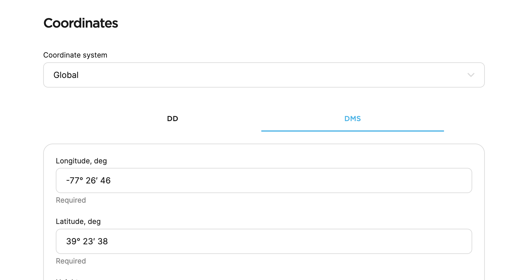
And one last thing: I’ve tried to create a point in the project with the coordinates you shared, and it was displayed fine, right in the US. This is how I entered the data: