When I input extracted the UBX raw files into EMlid Studio, unlike for the rover, the base files don’t seem to get the antenna height from the csv file.
Why is that? Does this means I must always record manually on a sheet of paper or somewhere on a device the antenna height during my field work so I can write it manually again during post-process??
To make life easier, use a FIXED HEIGHT ROVER POLE (i.e. 2M) with a ROVER POLE TRIPOD (good idea to use sand weight bags on feet in case of blow over). This way your base is always 2M from ARP (bottom of receiver) to point of observation. (Double check if you need to add APC also to 2M?)
Couple fair priced options below, but other options to which are more expensive. There are Carbon Fiber rover poles that break down into 4 sections also. Extendable rover poles also if you need your base higher.
AdirPro Aluminum GPS Rover Rod – 2m 2-Piece Design GPS Pole for Land Surveying & Engineering – RTK GPS/GNSS Accessory – Includes Level Vial & Carrying Case (Fluorescent Yellow) Amazon.com
AdirPro Prism Pole Tripod – Aluminum Range Pole Tripod – Use for Survey Pole, Rover Rod, GPS Pole – GNSS RTK Rod Stand - Survey Equipment for Total Station Surveying (Fluorescent Green) Amazon.com
Unfortunately, all those messages and advices do not answer my question.
If I have input the base antenna height in the base parameter in EmlidFlow app, it has to be stored somewhere? Whether in the csv or in raw data recordings? Otherwise, why bother making it a parameter if I must manually write it down in the post process?
For the Rover, it’s in the EmlidFlow app csv output file. It’s saved for each reading in the Antenna height field. So for me that’s a 1.8m pole, plus an offset of .134m for the APC offset.
Name
Code
Easting
Northing
Elevation
Description
Longitude
Latitude
Ellipsoidal height
Origin
Tilt angle
Easting RMS
Northing RMS
Elevation RMS
Lateral RMS
Antenna height
Antenna height units
Solution status
gcp 1
379.153
sw inside field
430.605
Global
1
0.012
0.012
0.011
0.016
1.934
m
FIX
gcp 2
375.646
sw inside field by wall
427.094
Global
1
0.012
0.012
0.011
0.016
1.934
m
FIX
For your Base, it should be in the header of the RINEX log files. This is from the .24O of my RS3:
                    EMLID REACH RS3                         REC # / TYPE / VERS
                    EML_REACH_RS3   NONE                    ANT # / TYPE
  3600000.7483  -140000.0329  5194790.7310                  APPROX POSITION XYZ
        1.8000        0.0000        0.0000                  ANTENNA: DELTA H/E/N
It doesn’t seem to save the 0.134m APC offset in there, just the height to the base of the unit.
oh… so do I understand that if I saved my raw data as .ubx format there is NO WAY to retrieve base antenna height unless I have written it somewhere else?
If you’ve used EmlidFlow to record your points, then you should be able to find the Base coordinates and it’s Ellipsoidal Height from the CSV export file. I’m taking this to be the base’s position, it’s height including both the pole height you entered and the APC offset.
do I understand that if I saved my raw data as .ubx format there is NO WAY to retrieve base antenna height unless I have written it somewhere else?
I believe that is correct. The UBX file is simply a log of what the receiver sees. Antenna heights are accounted for in Emlid Flow projects. The antenna heights have nothing to do with the log of what the receiver sees. Apples and Oranges.
Javad units are the same way unless it’s inputted using their software. Just starting the unit for a static observation it does not know the antenna height. Most receivers are the same way.
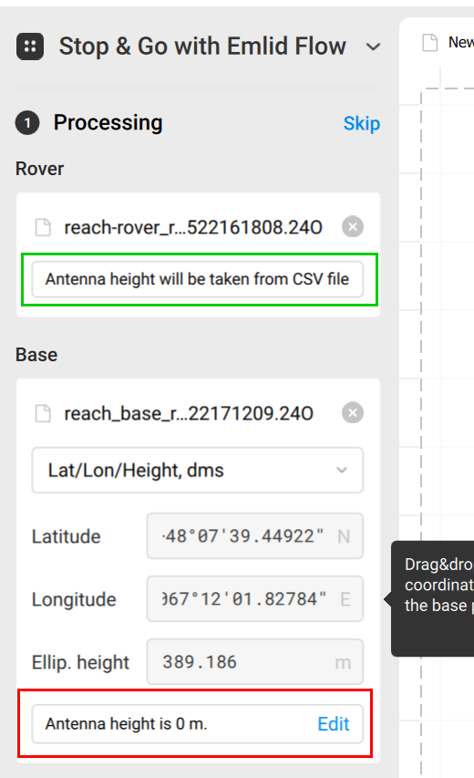
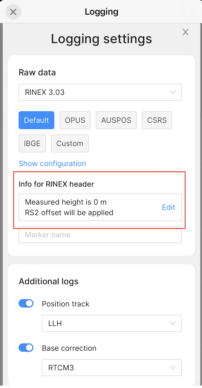
The CSV files contain information about the rover’s antenna height. To have antenna height stored in the base RINEX file, you need to specify it in the Logging tab. You can check on the Emlid Flow app Logging by clicking on Receivers, and you will see the antenna height on Info for the RINEX header.

What @dpitman mentioned is right.UBX files do not contain this information; it is saved only in the RINEX files.
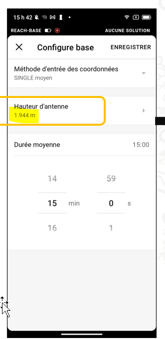
You can also check the Emlid Flow app to see if any information is still saved from the previous survey. On the app, go to Base settings and check the Antenna height.