


When setting up the reach rs rover and base station as per manual the status page on the rover shows indication for base and rover satellite reception but the status page on the base only has indication for the rover. Is this normal or do i have it set up incorrectly?
This is normal. Correction data is going only in one direction, from the base to the rover, so the base does not have any info from the rover, but the rover shows both.
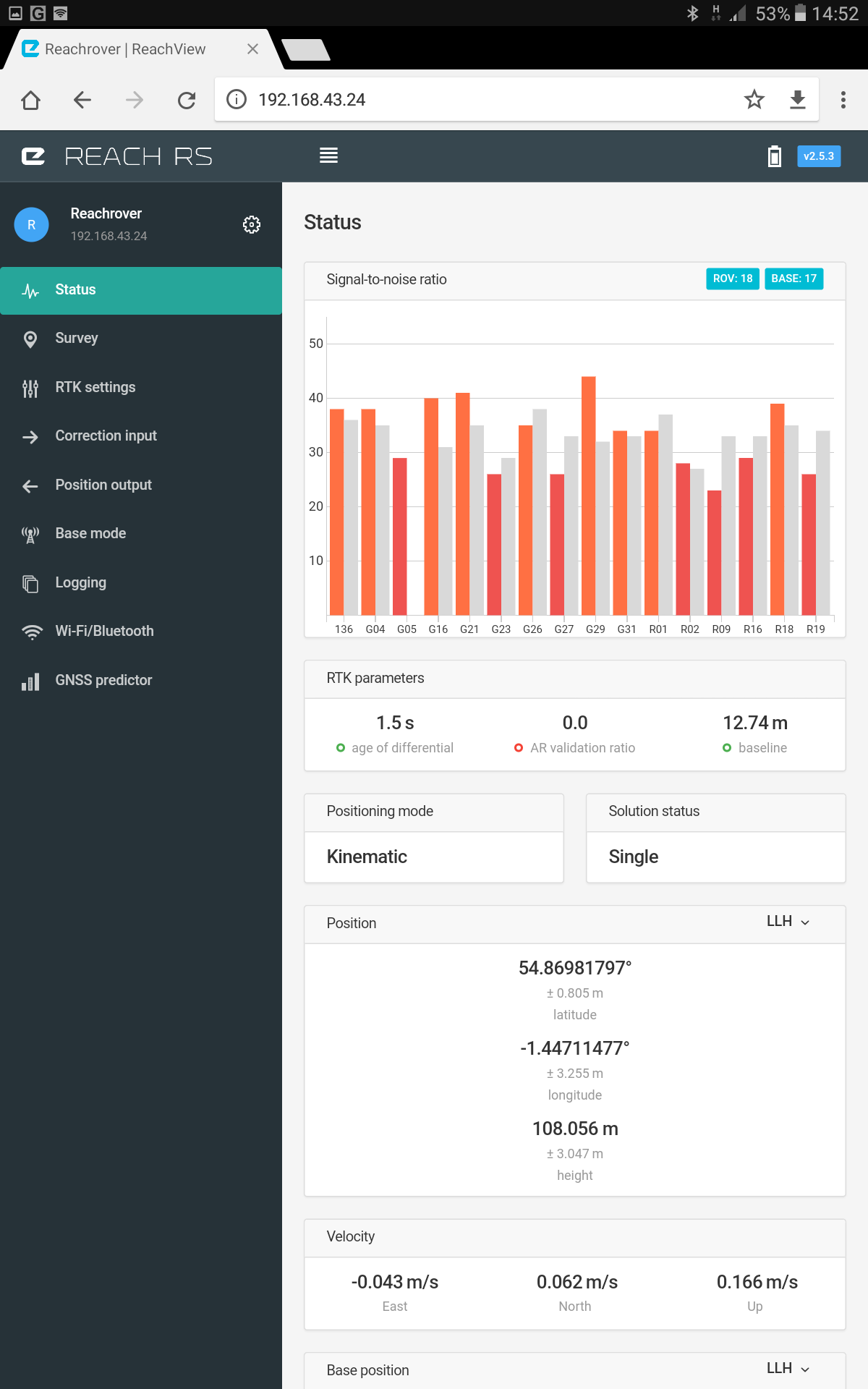
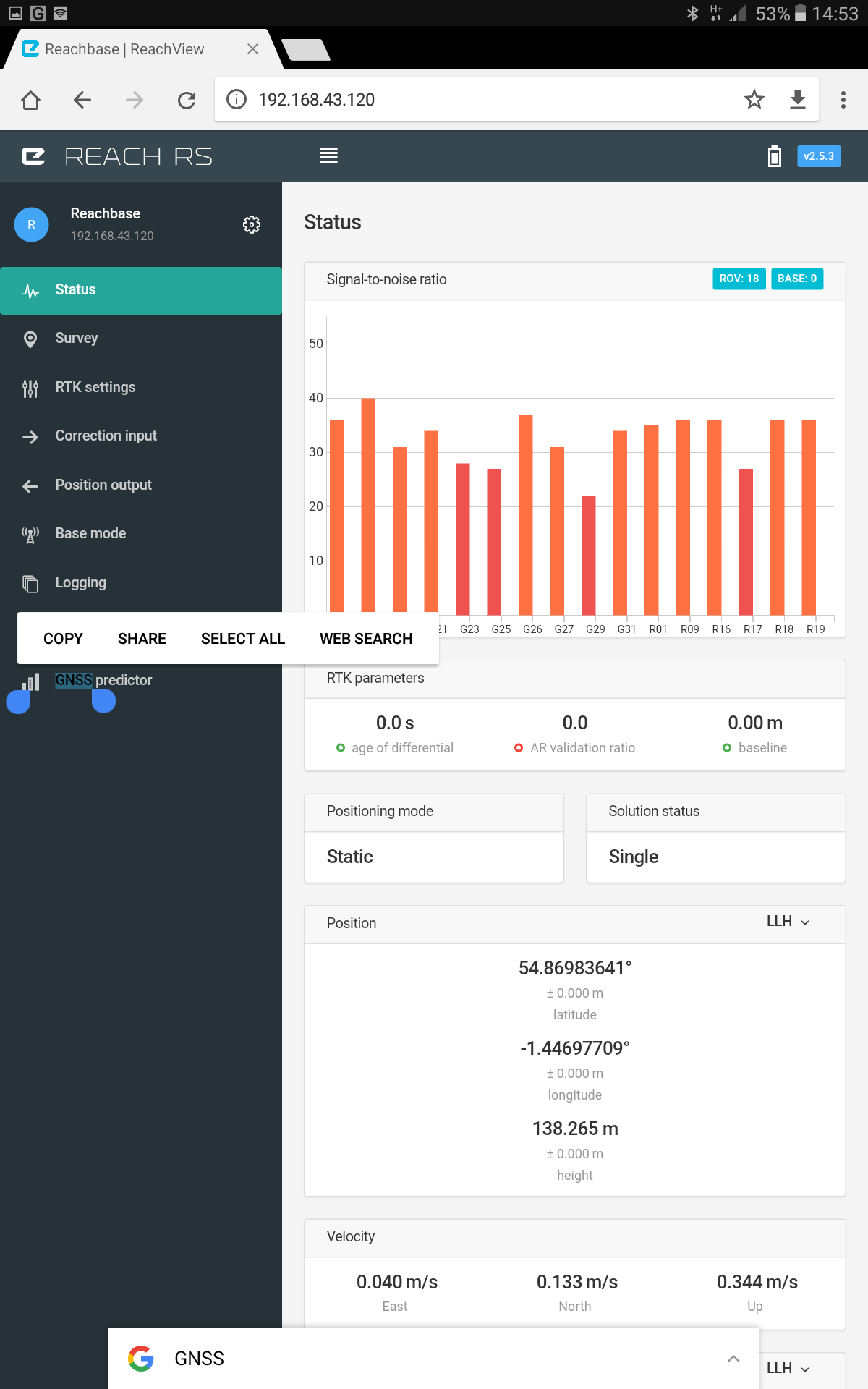
Thanks for that Brent, just to be certain on the photograph of the Base Status page it has ROV 18 BASE 0 and on the Rover Status page it has ROV 18 Base 17. Thanks for your help again
Yes, this is correct. On the “base” status page the “base” is the “rover” 
1 Like
Thanks again Brent, as you might have guessed I am a complete novice and I am pretty sure that won’t be my last question. Out of interest what sort of accuracy should I expect with just the Rover and The Base station ( no CORS or post-processing) ? Thanks again
You can expect cm level accuracy when measuring where your rover is relative to your base station. This is called relative accuracy. If you place your base station over a known point and enter in accurate real world coordinates, then your rover will provide you with cm level accuracy in real world coordinates( absolute accuracy)
2 Likes
So if I get a know co-ordinate from say, Google maps and enter it into the base station I would get that level of accuracy? Thanks again Brent , this is all very helpful .
Hi Brent , sorry to bother you again. Could you tell me which section of the app i use to enter the base position please? Thanks again
It would be accurate to the same level of accuracy you would be able to pick off of Google maps, which would, in my understanding, would be accurate at best to several metres. If you require high accuracy absolute positioning, I know of the following options. These would all be used to determine absolute location of your base station.
- Post processing (by downloading data from same time frame and using it to determine base station position)
- Uploading your data to sites such as http://webapp.geod.nrcan.gc.ca/geod/tools-outils/ppp.php?locale=en
3.Placing your base station over a known point
a. This could be a government registered survey control point.
b. You could hire a surveyor to come measure a point and give you coordinates and then you could always locate your base station at this place. - You can also set your base station to start measuring for a preset time after power up and then averaging it’s position. This is what I use. I can’t say just what absolute (real-world) accuracy it provides but it’s good enough for me. This way the base station automatically gives itself a position and you don’t have to access it via reachview app, just power it up, it starts measuring, establishes its position, and begins transmitting data correction to rover.
In order to enter base position in Reachview, access base station in Reachview and go to base mode and under Coordinates input mode select “manual”
There you’ll find the option to enter coordinates.
for more info refer to docs
https://docs.emlid.com/reachrs/common/reachview/base-mode/
Thanks for all this advice Brent, its really appreciated. Thanks again
1 Like
This topic was automatically closed 100 days after the last reply. New replies are no longer allowed.