Hello,
Today, I wanted to perform a test using VRS (Virtual Reference System) to measure the coordinates of a known point. However, the Fix provided by EmlidFlow is 20cm too high. The X and Y coordinates are accurate (<1cm).
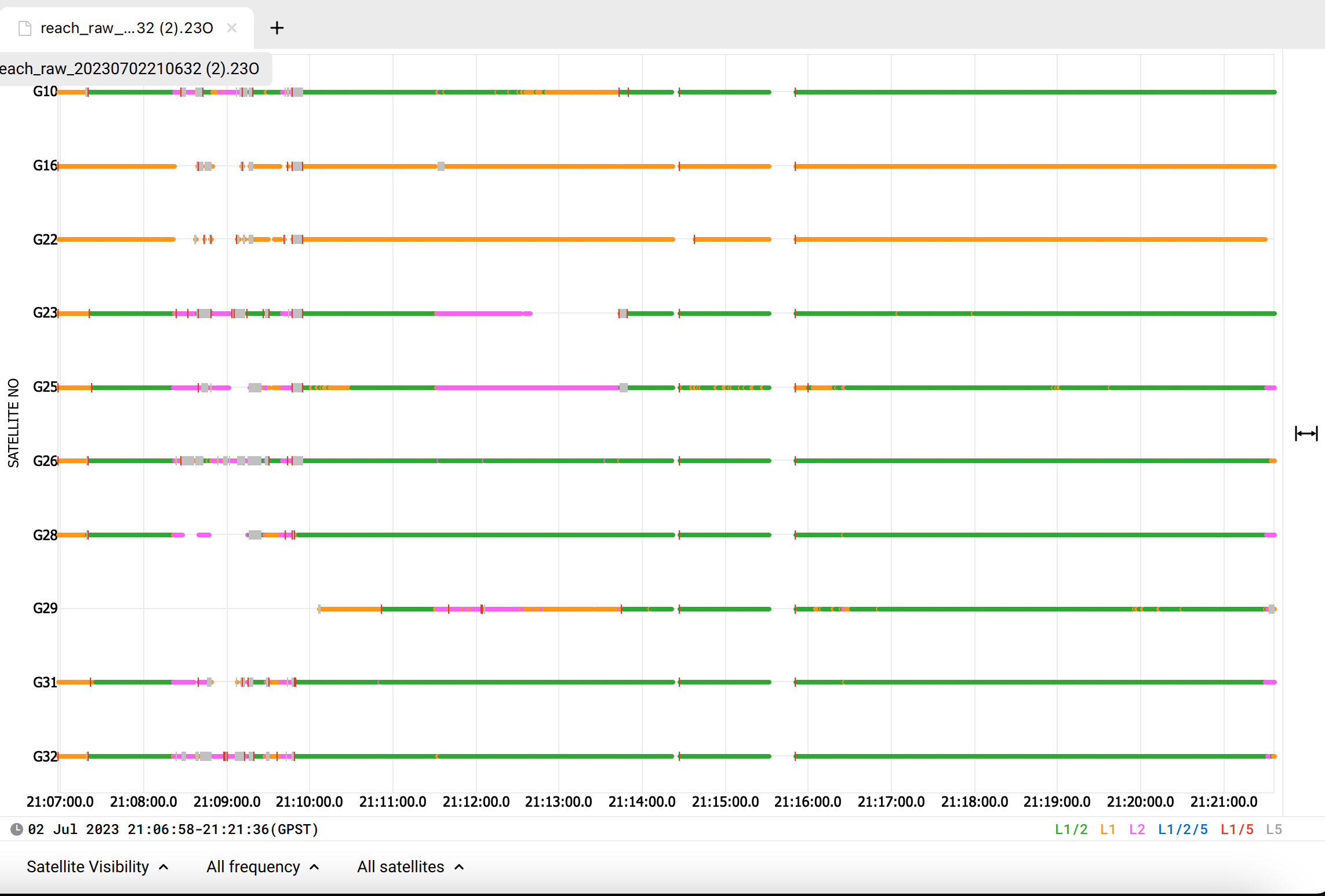
As a result, I tried to verify it with EMLID Studio, but I couldn’t obtain a fix.
My project is on RGPF/UTM6S and I have worked exclusively with ellipsoidal height.
We’ve checked your data, but we couldn’t get FIX in Emlid Studio either because your logs seem noisy. Usually, it happens when the sky view is partially blocked by obstacles such as trees or buildings or when the device is affected by RF noise.
Please collect some PPK data for comparison, because it could help to localize the issue. In the Logging tab, please enable UBX withRaw data debug, Position track , and Base correction and record the logs for at least 10-15 minutes. Additionally:
Make sure your receiver’s environmental conditions are right. It needs to have a clear sky view 30 degrees above the horizon. And keep all electronics as far as possible from Reach since they may produce RF noise that could affect the reception of the GNSS signal.
Try to connect to another base station with NTRIP.
Do you experience the same shift in other surveys?
Could you check if the vertical datum between your project and the known point are coherent ? There is currently ~25 cm between IGN 1966, the old system, and NGPF, the new one. That could explain your issue. See my post and comment here.
From my experience, this can also be an error between the antenna height in the app and the real antenna height of the pole in your hands. Sorry to mention it, it seems obvious, but I saw a lot of people throughout the years do this mistake of pulling the pole at 2.00m and setting it at 1,80 in the app. So better check !
On peut se parler en Français mais pour le suivi du forum j’ai conservé l’anglais
Hi Florian,
For this test, I only used the ellipsoidal height. I prefer to make my corrections after with Circé 4 and the latest GOIDE. My pole height is good : 2.00m…
Hi Zoltan,
I was in the mountains with no vegetation and no buildings nearby. The terrain was clear.
I’m going to conduct more tests in the coming days on a known point, and I will keep you informed.