“Averaging RTK fix solution is much more accurate than single averaging and is made possible when the receiver used as the base is configured to obtain NTRIP corrections over the Internet. This might be useful if the reference station is located far away. Reducing the baseline by installing the local base improves the positioning performance of rover.”
Does it mean my RS2 can works simultaneously with input correction ON & ouput correction ON ?
input correction to get a FIX solution (from a NTRIP subscription)
ouput correction to send correction to my rover through my EMLIB CASTER
Yes and no. It does get fix from NTRIP long enough to get its average position location then becomes a single solution from that location. It is getting a better relative location that way.
Single averaging is basically averaging your location with no correction data from the satellites available.
So if you switch mode to Manual using the averaged point, you need to add the height.
But it acutally a good question, it should likely be to ARP (bottom on the antenna), so it is easier to account for the difference L1/L2 phase center height).
Averaged height relates to antena phase center position.
To calculate height of the point bellow RS2 you need to deduce RS2 offset (0.134 m) and measured distance/height from point to bottom of antena, from avg height.
Hpoint = avgH - 0 134 m - measured H of instrument
I have done it like this and it was fine. It was 3 days project, and I mounted RS2 over the same pin every morning using tripod.
First day I used avg. Fix for 10 minutes (recieved corrections over NTRIP).
The next 2 days I used manual and entered calculated coordinates for the pin and height of the instrument = measured height to bottom of antena + 0.134 m
As I determined coordinates of my pin the first day using NTRIP corrections, I didn’t need to use- pay NTRIP next 2 days
yes I would prefer that way, ARP measure instead of phase center measure.
watch out in the RINEX header of your log.
If UBX log is being post processed to recompute the absolute position (eg NRCAN service) ones has to force in the RINEX header the Rec #/type/vers & Ant #/Type
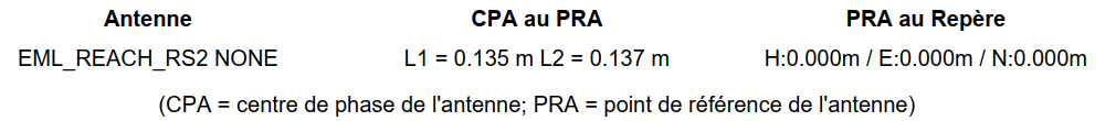
then NRCAN reads correctly the antenna model and returns L1/L2 phase center height in the PPP solution (the solution will therefore be the absolute position of ARP), like below (it’s an extract of NRCAN report)
The phase centers are found in laboratory tests. RS2 had unknown offsets until the second half of last year and we had offsets of 0 to use and simply added 0.134m to total antenna height.
I can confirm that the base’s averaged position is calculated for the antenna phase center.
If you want to input a known survey mark’s coordinates, you need to add the pole’s height and the 0.134 m offset to the value. In this case, it will show the physical position of the antenna.