I’ve been using an RS2 base/rover setup with great success recently on site that have a benchmark, but wanted to try and get familiar with using our state’s CORS system as well.
I am able to connect to the NTRIP service with the RS2 and can see all of the mountpoints available. The easting and northing values seem super accurate but I’m showing a little less than 100’ lower than I should be (showing 1311.xx and the actual site is 1406.xx). The mount points I’ve tried using are in the 14-25km range.
The documentation for Arizona is pretty minimal Link to AZ CORS Info but it does reference NAD83.
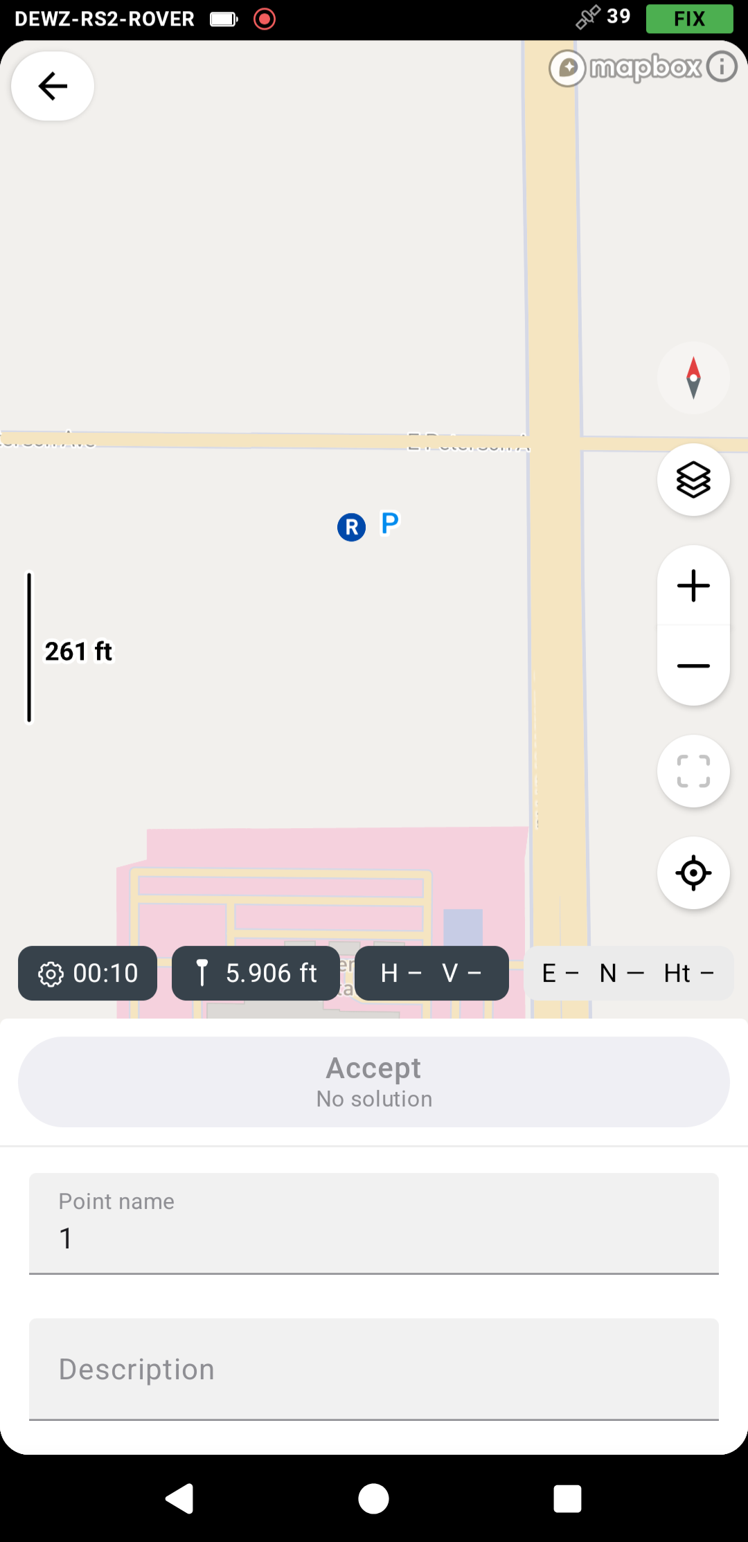
Looking at some of the MCDOT Survey Points it appears they use NAVD88 for the vertical datum. If I select that within a test project, I alway show a greyed out ‘Accept’ button when trying to set a point, with “No Solution” shown under it. This is despite having a FIX.
I’m hoping there is something painfully simple I’m missing that is right in front of me.
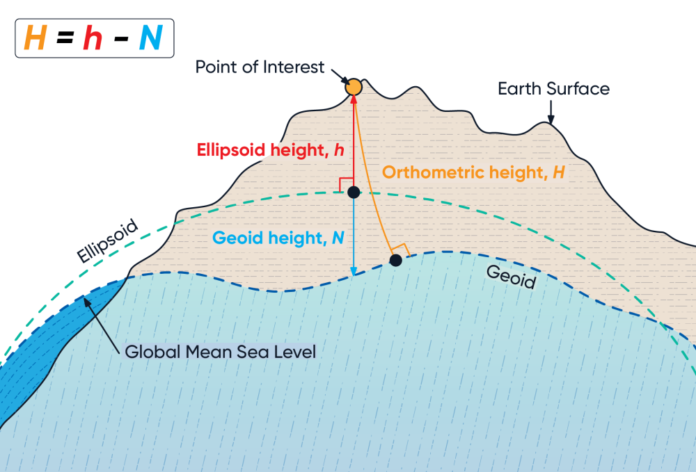
Yes, it sounds like you’re missing a geoid model in your projection settings. If you’re in Maricopa or Pima County, AZCORS offers a network solution called a Virtual Reference Station (VRS) which offers the best results over a single station. Look for the mountpoint named “VRS_MSM5”. This works well with the Emlid units. I use it all the time here in Tucson.
Yes, the geoid is important, took me a while to figure it out but the great thing about the current Emlid ‘survey’ package is…you can change it in your project, and it will convert all points to the new elevation.
hope this helps a little bit.
boston
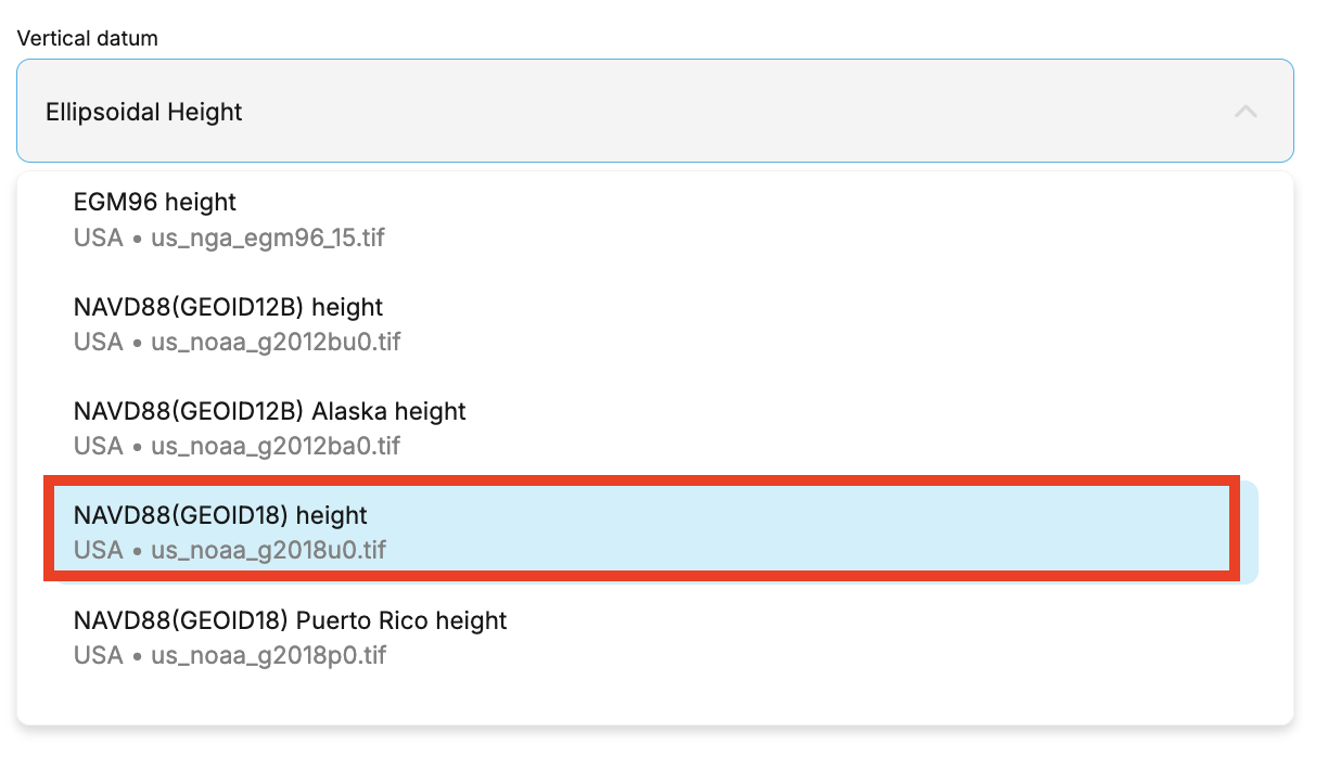
It’s likely that Ellipsoid height was chosen during project setup. If so, you could change the coordinate system of your project by following this guide. After that, Flow will recalculate the coordinates for you.
In your case, please choose GEOID18 from the list.
I’ve tried to play around with this some more and I think I have a better understanding of it, but I’m curious is switching between using a Base/Rover and just a Rover with NTRIP is something people often do on a project? Of course, we want the best accuracy possible, but there are times were not setting up the base would be a nice time saver if it is a quick sanity check on something.
When I switch the vertical datum on a project that was started with a base/rover using ellipsoidal height to GEOID18, it adjusts all of the previous points as well, which is incorrect. If i capture a point with NTRIP and then revert back to ellipsoidal height, then the NTRIP point is off.
I tried exporting as a CSV, altering the measurements and then importing back, but this seems like there’s a lot of room for human error. Currently, I landed on just creating two projects, one for base/rover and one for NTRIP. It’s a little bit of an inconvenience having to switch back and forth two compare points and you do lose the inverse/traverse functions, but it might be the best compromise.
It depends. If you have existing control points in the survey area, then using the base/rover setup would be much better, as you don’t have to rely too much on external correction sources.
If you do not have any existing controls and your survey requires absolute accuracy, then using an NTRIP service would be the best solution.
If you change the project’s coordinate system, all the points will be recomputed accordingly.
I’m not sure what this means. Why do you need to revert to Ellipsoid height after?
How does this setup work? For the base and rover setup, how do you set up your base? Do you set it up over a known point, or average it in Single or Fix? For a rover with NTRIP, do you use the two GNSS receivers as rovers?
I believe I’m missing an important detail in your setup, which is resulting in confusion.