


Hello,
How can it be done, or how colleagues usually do the adjustment of an RTK survey that was done based on an average position and then the base is processed and all points of the survey must be adjusted?
A practical, but not ideal, way is the translation of the points.
Is there any way to do this in RV3 or Emlid studio?
1 Like
Yes. I believe that you are referring to updating your base position with the processed solution from NRCAN, OPUS, AUSPOS, or whatever service you are using. You can do this with stop and go. You should be able to update your base position there. Check out this video at about 8min in.
2 Likes
Hi Mauricio,
I agree with Zach @Zaz5400 – Stop & Go can help you adjust the survey according to the corrected base position. To work with it, you can follow this step-by-step guide from Emlid Studio docs.
During the processing, you’ll need to enter the base position manually. And as a result, all the points’ coordinates will be calculated relative to it.
3 Likes
Good afternoon,
Actually, that’s not what I’d like.
In case I don’t have raw data (PPK or Stop and Go) how do I correct the withdrawal?
One answer I found is using a plugin in QGis.
In it, I transform the coordinates into the geocentric system (XYZ), a system in which GNSS works natively.
After that I apply the deltas (X, Y, Z) from the base to all points.
After that, I transform the points from X, Y, Z to Geodesic (L, L, h) and to UTM (E, N, h) if applicable.
So, in short, I apply the correction (delta E, delta N and delta h) at the origin (XYZ) and then recalculate the system.
It basically simulates what some controllers do.
It’s still a very laborious process, but it does the trick.
It even solves in cases of spindle error during lifting.
Hi Mauricio,
If I understand you correctly, you still need a known point in your working area to make the described correction of the survey possible. Hence, if you know such a point before your survey, you can use the Base shift feature in the ReachView 3 app.
For Post-Processing, we don’t have similar features in the Emlid Studio. PPK requires raw data logs from a base and a rover to correct survey data.
1 Like
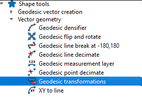
yes use the tools in qgis to shift all your RTK points. so you have the original x,y for the base (’ based on an average position ') and you have the improved x,y for the base (“base is processed”). calculate the distance and direction between the points and shift your work base on that difference. i use this plugin to shift…https://github.com/NationalSecurityAgency/qgis-shapetools-plugin
1 Like
thanks tracy.love
I will test this
This topic was automatically closed 100 days after the last reply. New replies are no longer allowed.