


If there is no metadata that explicitly states what datum they broadcast, I think it’s safe to assume almost any WGS84 version would work but to be sure you could send them an e-mail. Looking at their stations map, I can see the coordinates, but not the datum. I can’t see if there is more info behind the paywalled user site.
Where would I find the metadata to review?
Where is this at ??? Is it in the USA ?? If so, NAD83/NAVD88. Also what state ? Coords may be State Plane Coordinate System.
The points were collected on Nantucket Island Massachusetts. They are in NAD83 accidentally and not NAD83(2011) but captured with ellipsoid. I’m using the vertical datum transform website to convert over to NAVD88 but don’t know what reference frame I need to use for the vertical side to then convert over to NAVD88.


1 Like
In that dropdown list, the darker blue choices are orthometric datums and the pale blue ones are ellipsoidal. Assuming the stations broadcast their positions as raw WGS84 I’m assuming using any ITRF2008 or ITRF2014 based datum as your source CRS should work as the differences wouldn’t have much impact unless you really need millimeter precision.
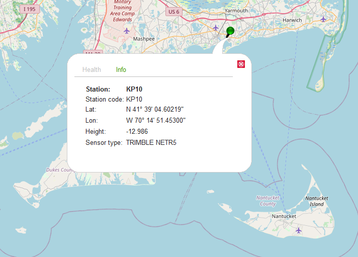
If you look at the KP10 station, the coordinates seem like it’s straight up WGS84 (from the height value alone). If you can find out which ellipsoid the stations use, you’ll be able to match it in that dropdown menu but the resulting differences might not be very large anyway.
So I walked through everything I am doing and it appears I am missing something. Maybe someone can view this video and tell me what this newbie is doing incorrectly?
I’d contact the RTN people, the RTN stations are probably NAD83 2011, vertical NAVD88. If you could look at a datasheet for any of the stations, that would tell you what datum they’re on.
Here is a screen shot of my RV3. Since it shows that I collected in NAD83 not 2011, am I selecting the correct one for the input side or should the input side be what ever the RTN is collecting in?

Also I’m attaching my GCPs maybe someone will recognize the format that the easting, northing, and height at and tell me differently.

Yep! So when creating the project innRV3, the project system should match your RTN provider.
If your RTN provides ortho height, you are out of lock. Reach unit expect elipsoid for now.
Ok so the RTN documentation shows that it is NAD83(2011). I selected NAD83. Does that mean RV3 still only collected whatever the RTN puts out no matter what I select?
Someone was able to help me get them converted. Anyone see anything that doesn’t look normal here?
|1|1742079.073|93464.025|14.788|
|2|1743610.896|93404.308|30.61|
|3|1745469.63|93119.275|29.716|
|4|1743277.159|94587.739|25.325|
|5|1744409.125|94122.883|32.089|
|6|1745480.92|94722.24|27.335|
|7|1746048.193|95676.303|28.729|
|8|1746762.403|96400.269|31.903|
What vertical datum ? I’m sure it’s NAVD88 with GEOID18…
Yes that should be it.
1 Like
That’s usually with at least here in USA RTN’s
Hi everyone,
I just wanted to briefly comment on ReachView 3 workflow.
When you’re working with a specific coordinate system in ReachView 3, the app always gives you a hint about the base station coordinate system. It’s set as a default for the calculations and can’t be changed. In this case, it’s NAD83.
So, for ReachView 3 to give you the result in the required CS, your correction service needs to provide the data in NAD83. If that’s not the case, there might be offsets in the end results.
2 Likes
This topic was automatically closed 100 days after the last reply. New replies are no longer allowed.