


Disregard. I did a simple Google search to determine they do not.
No, it’s really not that simple because your scenario is obviously way different than ours as ours has been from MANY others that I have consulted. Where our scenario is typical is in the construction and surveying space. Every group that I have talked to that is trying to do what we do are falling short and struggling for just this reason. No one that I have come in contact with in my 20+ years in land development and the AEC industry surveys like this. At least not in Texas. This is probably why the survey and engineering topographic surveys we use for construction are always busted when it is time to actually build.
You either have idiots providing errounous data or probably typically don’t know what they are doing. Being a licensed Surveyor in the Great State of SC RLS 11056 since 1986 gives me the knowledge to state this. We have attended various NGS seminars down through the years, completed various Geodetic networks throughout the state that have been submitted into the NSRS (National Spatial Reference System) and other local state, county and commercial agencies. Our firm was the first to perform a 60 station photogrammetric control network using the first commercial Gps L1 receivers back in the late -80’s. Some of those control marks were submitted to the NGS then via bluebooking and have been and are still in the NGS database.
I know what I’m talking about. We have even corrected other so-called professional surveyors that haven’t a clue in the use of GPS/GNSS.
I suspect that is yours and others in the UAV profession problem. There’s nothing wrong with being self-taught in any work, however college degrees, licensure and active seminar training goes a long way in understanding geodetic principles… even for the self taught, an active participation with qualified Licenced Register Surveyors knowledgeable in this specific field goes a long way… people like me.
I don’t get into the degree of accuracy you are for my application of GPS.
I will say, as with any technical field, actual experience goes a long way. Theory and “application” are taught in schools but, when the rubber meets the road, practical experience/troubleshooting tends to prevail.
2 Likes
I am in no way saying that you don’t know YOUR stuff, but it sounds like you are out of touch with what happens with your Geodetic control once it has left your hands. The OP is related to UAV surveying and Ground Control Points and you definitely are not speaking in terms of that scope. Drone mapping is very rarely used on grid from the MANY cases I have consulted, presented on and the thousands are missions we have flown so there is a big disconnect between the way you do things and the way the world is actually built. Localization is the base point of this disconnect and is how everything is located in development, construction and what most people think of as land surveying whether you are using a GNSS system or an optical instrument and resecting. Being absolutely accurate to the rest of the globe is not part of it and until people understand that we are speaking in terms of site surveying and surface coordinates there will always be this misunderstanding. I doubt very few people on here are performing Geodetic surveys so we need to be speaking the right language and paying attention to the actual use-case.
1 Like
You people need to think in terms of ground versus geoid. That’s what I’ve been hammering into people for years. You just can’t fly around taking pictures or doing lidar without adequate vertical ground control, PERIOD.
On a recent 300 acre lidar project we had 20 ground control targets for the project scattered around and throughout the site. You simply can’t use geoid separations to determine true ground elevations without adequate local true benchmark data near the site. Three local NAVD88 benchmarks were witin 1 km of the site. That’s what was used for vertical control for the project. That’s why NGS has the Benchmark Campaign going on for the last 10 years, to try and refine the ground as accurate as possible to determine true geoid-orthometric heights
Edit:. If no true benchmarks exist, setup a small net and use it, better than nothing !
Yeah, this is why the NGS has a specific calculator to correct the leveled error between NAVD88 monuments and “adequate” vertical control is a pipe dream unless you want to do a 3-mile level loop every time.
Did you run a level-loop through those BM’s?
Yep, and throughout the ground targets with digital level.
2 Likes
New proposed industrial site, cost was prohibitive and client never balked… get it done whatever the cost.
2 Likes
All I can say is the contractors in your area are lucky. I’d love to be a fly on the wall when they are actually building with your data…
How long did your loop take?
2 Likes
Approx 4 days, I hate running levels. Used to enjoy when I was younger. The only reason I was in the field was I was in between mapping projects in the office and it needed to be done !!
2 Likes
I think a lot of determining topographic data is that nowadays, no one really knows how it used to be done terrestrially ( on the ground) either by grid or random level or by traverse using robot or total station. You can really waste a lot of time on the ground if you don’t know how to locate top of creek banks, both bottom channels, random breaks in the ground, etc. I hate seeing “v’s” for creeks or ditches. That tells me they don’t know how to locate creeks
We’ve done lots of “on the ground” topographic surveys thru the years. It’s just now that most engineering firms are starting to accept aerial products. I don’t blame them, I’ve seen to much crap out there without ground verification.
4 Likes
That is one beauty of aerial when we don’t have to shoot thousands of tops and toes any more. Even if we are off a tenth on the surface it is a hundred times more accurate than a grid and breaklines so all we have to do is shoot drainage structures and tie-ins.
4 Likes
If we can ever afford lidar, that’s the way we’ll go. Imagery and photogrammetric is fine when there are no leaves and out of pine forests, but lidar. Is the king. We’re fortunate to have 2008;lidar throughout the state, checks well with true ground elevations within parameters when flown. It amazes me when running typical boundary work. We always carry elevations whether with robot or GNSS. We usually and constantly see minimal vertical errors in the range of 0.5 ft. Design specs were for 2’ contours throughout the state. Pretty good for 2008 technology.
I figure I’ve got another 25 years left in me, I’ll be 88 and still surveying.
2 Likes
Same here on the Lidar. Now that we have it on iPads it shouldn’t be too far down the road that it will be much more affordable and not take a $15,000 drone that can carry 15lbs…
2 Likes
So I know how to do make a loop, and I know what to look for and how to use the result, but in this instance, what does the expected result provide the surveyor with?
It’s not uncommon for registered BM’s to not work together. Where we have the biggest problem is when they are not all registered by the same entity. Recording the level loop in the field book just provides the documentation that you’ve done your due diligence that either the recorded information is true or false. The fact that Bryan ran his loop through his ground control points is even more solid. This is what we do when we localize. When we set up the original control network for the construction project the level loop is run through all control points that are available on the CAD file including the property pins and the vertical datum then we have record of the elevation of everything to begin with.
2 Likes
True ground elevations based on surrounding existing vertical control.
Visualize two planes of a surface, one on existing ground and one as geoidal derived heights (GNSS use). In some areas of the USA, difference might not be more than 0.05-0.1 meter, others due to subsidence for example might be more… extremely more in areas of New Orleans for example.
For mapping of extremely large areas in true NAVD88 heights (level run ground surface) versus GNSS derived heights. This creates problems as you have two surfaces that don’t match.
Ground heights should be held or a scale factor applied (most instances for large areas) to GNSS derived heights. As said earlier, flying around with GNSS photogrammetry is not exactly mapping the ground surface without true ground vertical measurements throughout the mapped area to determine the actual geoid-orthometric/ground surface.
3 Likes
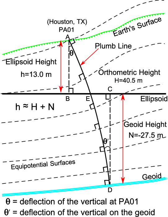
The whole purpose of below, to determine true
(refine) geoid-orthometric/ground separations.
I’ve been using that site for a long time and been recording whatever benchmarks I can find as we get close to them. Unfortunately there’s allot of open space in Texas between the highways and not much monumentation in-between so allot the this is poor or hasn’t been found in decades. If I do find one though I shoot it.
Here’s the thing though I have never seen those orthometric heights match the elevation datum on the plans. A couple have been close, but never within our tenth tolerance.
We started a project about two months ago that is next to a major toll road and a railroad and there were two NGS BM’s right next to the site. What was on our plans? One f’ing capped iron rod in the middle of a field right in between them! Oh and the soil is clay. Yep, let’s just say I didn’t expect a whole lot moving forward from this engineer.
2 Likes