RS2 showing bad L2 Data Quality

I got some more Info from the UAV Vendors Support. They have been in Contact with Septentrio regarding the Algorithm and apparently their PPK Software uses L2P measurements as well (that RS2 does not provide?) and may show Problems if they are missing and L2C/A Signals are not in available in a good quality.

We retried the PPK Solution with Data from SwiPos PP Service using a VRS and we could process the Data. We have performed some flights this week including RAW Data from RS2 in Rinex 3.03 Format using 2.20.0 Firmware. We got some mixed results for PPK Processing ranging vom 100% PPK Fix to 0% depending on the flight (of total 5 Flights).

So currently we will rely entirely on CORS/VRS from SwiPos for PPK. In the near future we will quantify the differences from using CORS/VRS, RS2 and another GNSS and crosscheck the results by using Ground Check Points.

Hey everyone,

Let me sum up what we know about this issue now.

Weā€™ve been in touch with the Wingtra support. At the moment, it seems like the software requires the GPS L2P data to correctly process the logs. Other than that, Iā€™m afraid we canā€™t be of much help with the third-party software algorithms.

Reach RS2 doesnā€™t record GPS L2P but tracks GPS L2C signal. Usually, the multi-frequency data Reach RS2 records is enough for the majority of the software. For example, I could post-process the logs with the RTKLib QT apps with an almost 96% fix solution.

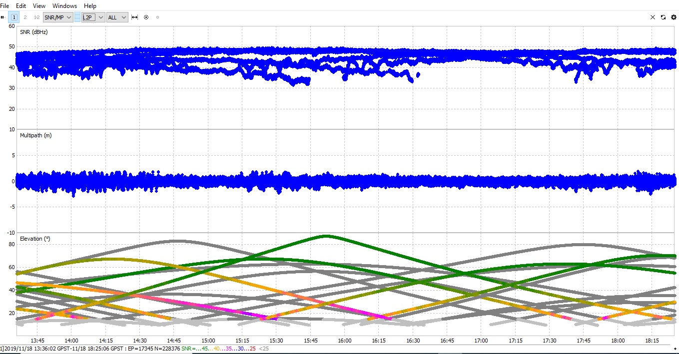
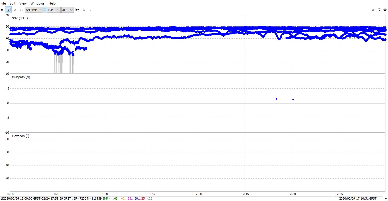
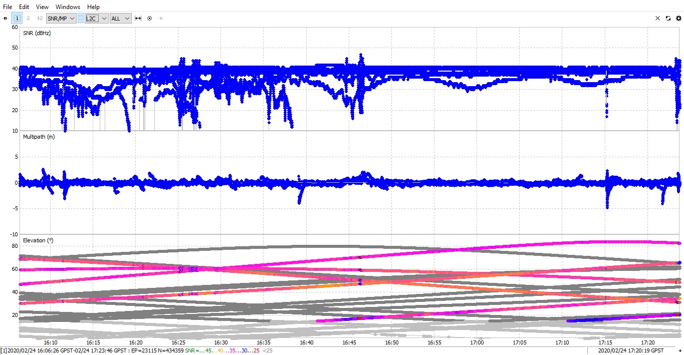
As I have described previously, the general quality of the multi-frequency data from Reach RS2 is okay. Iā€™ll post the screenshots below.

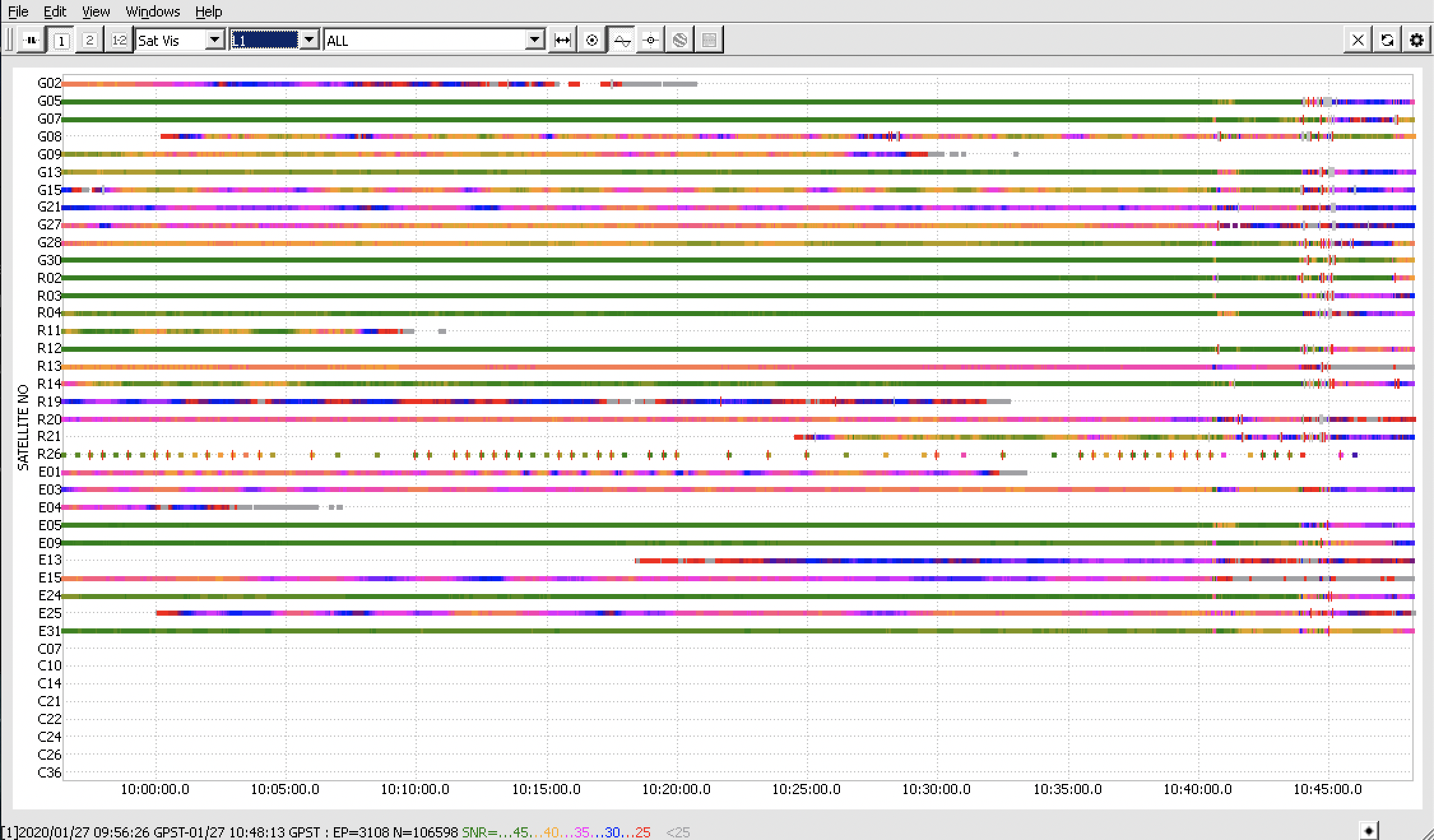
L1 recordings (stand for GPS/QZSS L1C/A, GLONASS L1OF, Galileo E1-B/C):

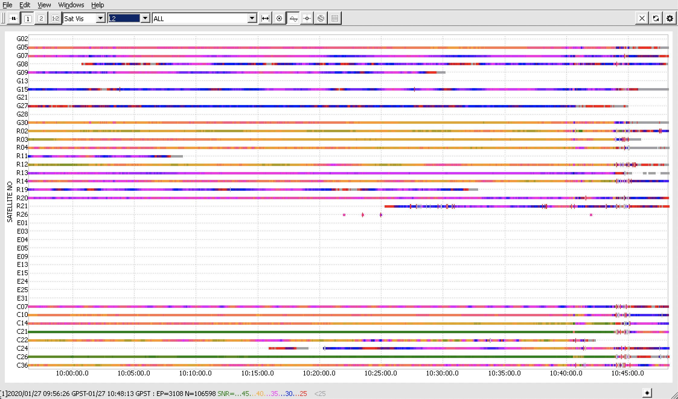
L2 recordings (stand for GPS L2C, GLONASS L2OF, BeiDou B1I):

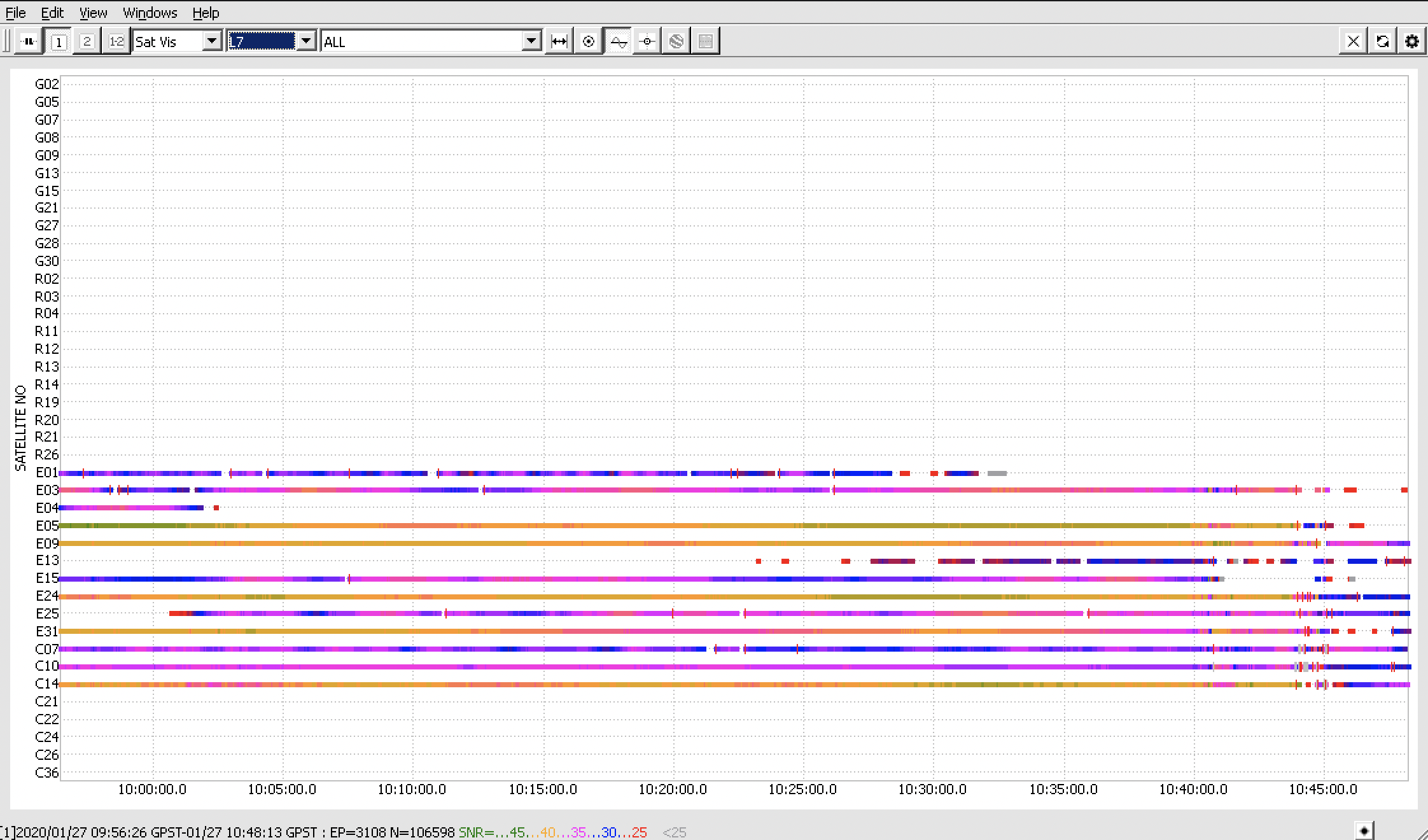
L7 recordings (stand for Galileo E5b, BeiDou B2I) :

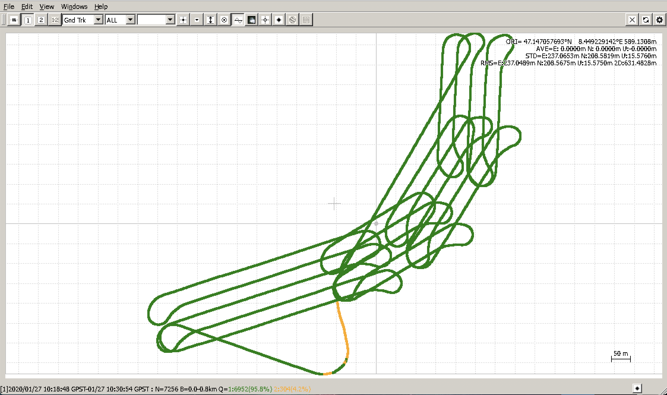
Also, the data quality from the drone is somewhat the same. Iā€™ve made the comparison on the satellites in my previous post.

However, the drone records only GPS+GLONASS data. Enabling other satellite systems like Galileo and Beidou would help collect more data which usually results in better post-processing results.

Currently, to help overcome the issues, I can recommend the following as Iā€™ve also described in this thread:

  • planning your survey so that there are enough satellites in view which are capable of transmitting L2-data. Certain predicting tools can be useful for that, like GNSS planning tool or GNSS radar

  • enabling as many satellite systems as possible because this helps collect more data for use in further calculations. Our default recommendation is all GNSS (GPS, GLONASS, Galileo, Beidou, and QZSS) enabled at 1 Hz for the base and 5 Hz for the rover.

Andreas, itā€™d be extremely interesting to see the results of your tests on comparison among the CORS/VRS, RS2 and another receiver. Hopefully, they will help us understand more about the reasons for the post-processing failures.

3 Likes

Hi @polina.buriak,

thanks a lot for your answer. Yes we plan to have a Survey conducted with the Drone where we plan to use CORS/VRS, Reach RS2 and a GNSS Receiver from the Drone Supplier so we can also crosscheck the accuracy between systems.

Currently we are using CORS resp. VRS only and we have pretty good results on the PPK (<2-3cm) respectively around 4-5cm on the processed Orthophotos. So currently we skip the effort of erecting the GNSS in the Field, as we can download VRS Data afterwards.

But we are eager to see VRS and PPK Results in general in more difficult conditions like mountains and canyons.

1 Like

Hi @bide. Sorry for the late response.

The other GPS donā€™t receive L2C, I suppose because they are quite old now. They only receive L2P. So I canĀ“t compare them directly with the RS2.

Only thing I can see is that they receive L2P with good SNR values, almost 50. And the RS2 receives L2C but with not such high SNR value, as it is about 40 all the time.

Other GPS

RS2

Hello,

We also have an Wingtra, but are looking to replace our very old Trimble Unit that we currently use for a base. Were you mostly able to work through the issues and is the RS2 something you would recommend at this point, or would you recommend something else?

Thanks

1 Like

Iā€™m interested in the answer to this question. We already have a pair of RS2s and we were thinking about getting a Wingtra. Itā€™s important to us that we understand how well these two systems play together.

@MapScience @mapossum we have not been able to successfully use the RS2 Unit together with the Wingtra Hub Software. Currently we are using CORS/VRS Data for the PPK.
Soon we plan to check together with Wingtra how the different Data Sources impact the Resulting Precision especially in difficult Areas (Mountains).

Thatā€™s a bummer, but thanks for replying.

Hey everyone,

I just wanted to point out that it was possible to process the logs from Reach RS2 and the Wingtra drone in RTKLib QT apps. So itā€™s possible to use Reach RS2 with your drone if you decide to work with our version of RTKLib software.

After the discussion with the Wingtra support, it seems like for the correct processing, the Wingtra ONE software required the GPS L2P data, which Reach RS2 doesnā€™t track. Apart from it, Iā€™m afraid thereā€™s not much we can help with regarding processing the logs with third-party software algorithms. Hopefully, additional tests from Andreas will be able to clear up what triggers the issue with the processing in Wingra.

Generally, to exclude the processing issues, Iā€™d suggest taking a look at the steps described previously in this thread and here as well. They give a glimpse into the overall approach to the post-processing survey.

Just thought I would post a follow up on this tread. We did end up purchasing a EMLID reach since we planned to mostly use it for doing GCP work and we can connect to our state RTN and CORS.

However, we were please to discover that we have been able to PPK process the raw RINEX files that our EMLID collects with the flight GPS and logs from the Wingtra in Wingtra Hub without issue. Perhaps something changed on Wingtraā€™s end since the original post.

3 Likes

This topic was automatically closed 100 days after the last reply. New replies are no longer allowed.